
 Return to list of Features

NB: typical illustrated examples are described, NOT ALL examples.
absence of evidence is not evidence of absence
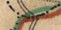
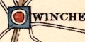
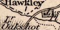
Settlements are positioned by a circle, differentiated by style of lettering. In Hampshire:-
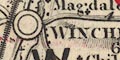
city :-
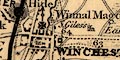
circle, cross for the cathedral, 2 stars for Members of Parliament; labelled in upright block caps:-
WINCHESTER
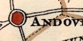
town :-
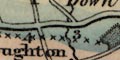
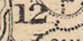
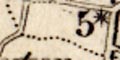
circle, perhaps 2 stars for Members of Parliament; labelled in upright lowercase text, eg:-
Southampton
Andover
Printed lower right on the North sheet is:-
This Map contains all the Market Towns in South Britain, and such Places in North Britain as are equivalent to them, every County in England is represented by two Members, and the Welch Counties by one apiece: All the Burroughs or Towns in Great Britain that have a Right to choose Members of Parliament are mark'd with one star or two, according to the number of Members elected by them: and whereas by the Union Act in 1707 divers alterations have been made in respect to the Representation of the Shires and Royal Burghs of North Britain, which cannot be well distinguished in the Map, the words of the Act itself here follow: ... ...Printed upper left on the North sheet:-
Having done a Map of South Britain with Ogilsby's [sic] Roads and others, and all the Post Towns as they now stand, Communicated to me by the Postmaster General; and likewise another of North Britain, with many Remarks relating to the Fishery, Woods, &c. I have now, to Comply with my Friends Importunities, Composed one intire Map of Great Britain, wherein, besides other useful Improvements, you have the Royall Borroughs of North Britain particularly distinguish'd, which were never done before, and some of them are not to be found in any Map. also the New Forts Viz. Bernera, Kilwhnimen, Ruthvan of Badenoch, and Innersnail.
The asterisks on city and boroughs are assumed to indicate the number of members returned to Parliament by the place; this map is in the era of rotten boroughs. The following places are represented:-
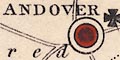
Andover - 2
Christchurch - 3
Lymington - 1
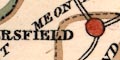
Petersfield - 2
Portsmouth - 2
Southampton - 2
Stockbridge - 2
Whitchurch - 2
Winchester - 2
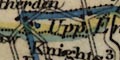
Settlements are positioned by a circle, differentiated by added symbols and style of lettering. The distance of towns from London is given with the place name. The number of members a place send to Parliament is indicated by stars.
city :-
circle, buildings and towers; labelled in upright block caps:-
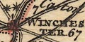
WINCHESTER / 67 [2 stars]
town :-
circle, building and tower; labelled in upright lowercase text, eg:-
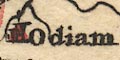
Odiham
Southampton / 78 [2 stars]
Stockbridge [2 stars]
The following towns are boroughs, sending members to Parliament:-
Andover 2
Christchurch 2
Lymington 2
Petersfield 2
Portsmouth 2
Southampton 2
Stockbridge 2
Whitchurch 2
Winchester 2
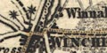
The two large towns. Winchester and Southampton, are drawn by groups of blocks on streets making tiny street maps. Other settlements are located by a circle, differentiated by added elements, and by the lettering style of their label.
city :-
group of blocks making a street plan; labelled in upright block caps, eg:-
WINCHESTERSouthampton is also shown in street plan style, but labelled in italic block caps. Both these places have two stars for members sent to Parliament.
town :-
circle, two minimalist towers; labelled in upright lowercase text, eg:-
Petersfield 56
Overton 53The number is the distance of the town from London.
Boroughs have stars for members sent to Parliament.
Some towns have two asterisks on spikes alongside; the number of stars probably indicates the number of members returned to Parliament by the town.
Settlements are perhaps shown by a few blocks, or just a cross for a village church. They are differentiated by style of labelling.
city :-
a few blocks around the meeting of roads; labelled in upright block caps, eg:-
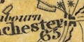
WINCHESTER / 65
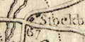
town :-
a few blocks by the road; labelled in upright lowercase text, eg:-
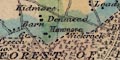
Stockbridge / 67
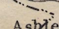
Alton / 48Southampton is made an exception, it is a large town and is labelled in italic block caps:-
SOUTHAMPTON / 76The figures are the distance from London. Borough towns have stars attached to show the number of members sent to Parliament; Stockbridge has two for instance.
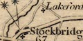
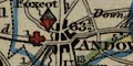
Settlements are shown by groups of blocks on roads, differentiated by labelling style.
city :-
group of blocks on roads; labelled in upright block caps, eg:-
WINCHESTER
town :-
groups of blocks on roads; labelled in upright lowercase text, eg:-
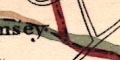
Stockbridge / 67
Fareham / 73Borough towns have one or two stars attached to show the number of members sent to Parliament, Andover, for example, has two.
Distances of towns from London are given in figures by its name.
Settlements are mostly marked by a circle, differentiated by style of lettering, and perhaps added symbols.
city :-
group of blocks; labelled in upright lowercase text:-
Winchester 65 [2 stars]
town :-
circle; labelled in upright lowercase text, eg:-
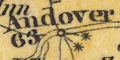
Andover 63 [2 stars]
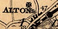
Alton 47Except:-
SOUTHAMPTON 77 [2 stars]marked by a group of blocks; labelled in upright block caps.
Borough towns are indicated by one or two stars, for the number of members sent to Parliament.
The number with the place name is its distance from London.
Settlements are shown by buildings or groups of buildings represented by blocks. They are differentiated by style of lettering, and have added elements for electoral data.
city :-
group of blocks; labelled in upright block caps:-
WINCHESTER / 64 [2 stars]The stars denote the number of members returned to Parliament. The figure is the distance from London.
town :-
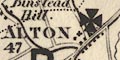
group of blocks; labelled in upright block caps, eg:-
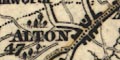
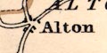
ALTON / 47
Running across the county is a boundary line of x's dividing it into electoral areas:-
NORTH DIVISION
SOUTH DIVISIONThe bounadry is tinted blue on the north side, pink on the south (which would not do in the present era of party politics).
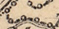
Borough boundaries are drawn by a line with spots on it, tinted a dark blue:-
These boundaries cut across the hundred boundaries.
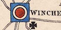
Settlement are marked by blocks, singly or in groups, perhaps arranged on streets, and are differentiated by style of lettering.
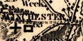
city :-
group of blocks on streets; labelled in upright block caps:-
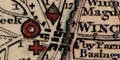
WINCHESTER / By Farnham 65 1/4 / Basingstoke 62 1/2 [red ring, red cross, red rhombus]Principal place of county election; polling place; returns 2 members to Parliament. The figures are distances from London.
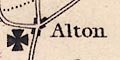
town :-
group of blocks by a road or on a street plan, with a cross; labelled in upright block caps, eg:-
ANDOVER / 63 1/2 [red cross, red rhombus]
Drawn across the map is a bounadry between the North Division and South Division, a dot dash line. THis is not tinted, except where, by chance? it is also a parish union boundary. The two areas are labelled:-
NORTH DIVISION
SOUTH DIVISIONAt the top of the early edition of the map is:-
PLACE of ELECTION for the NORTHERN DIVISION.- Winchester.
POLLING PLACES.- Alton, Andover, Basingstoke, Bishop's Waltham, Kingsclere, Odiham, Petersfield.
PLACE of ELECTION for the SOUTHERN DIVISION.-Southampton.
POLLING PLACES.- Fareham, Lymington, Portsmouth, Ringwood, Romsey.
Only necessary settlements are marked; plus a few extras whose relevance is not immediately apparent. Perhaps accompanying text, which we do not have, might make their inclusion clear.
city & town :-
Borough towns have the red circle, maybe with an outer circle, showing they return 1, or 2, members to Parliament; labelled in upright block caps, eg:-
WINCHESTER [returns 2 members, principal place of county election]
ANDOVER [returns 2 members]
PETERSFIELD [returns 1 member]Other towns are marked by a few blocks by their roads; labelled in upright lowercase text, eg:-
Alton
Basingstoke
A dot dash line tinted red is the proposed boundary between divisions of the county, labelled:-
NORTHERN DIVISION
SOUTHERN DIVISIONThis is (?) the division boundary which came into force with the Reform Act 1832. A second dot dash boundary is engraved on the map, tinted green on one copy. This might be an alternative division?
Printed lower left is a table of:-
DISTRICT DIVISIONS
North
Alton
Andover
Basingstoke
Kingsclere
Droxford
Odiham
Petersfield
Winchester
South
Fareham
Lymington
Ringwood
Romsey
Southampton(Should it be Bishops Waltham rather than Droxford?)
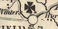
Settlements are marked by groups of blocks, perhaps a cross (+) for a church. The smallest places might just have the cross. Places are differentiated by the style of their labelling, and may have extra symbols for their electoral function, which are described in the table of symbols.
city :-
group of blocks; labelled in upright block caps:-
WINCHESTER / 63 [cross; 2 stars]
town :-
group of blocks; labelled in italic block caps, eg:-
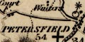
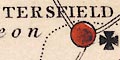
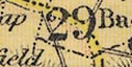
PETERSFIELD / 54 [cross; 1 star]
STOCKBRIDGE / 66The number with the name is the distance from London. A cross signifies a polling place; the stars indiacate the number of members returned to Parliament.
The electoral status of Hampshire's towns is summarised below:-
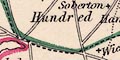
Hundred boundaries are dotted lines. The hundred areas are labelled with a number referring to a table of hundreds printed upper left:-
REFERENCE TO THE DIVISIONS HUNDREDS & LIBERTIES
Andover Division
Andover Hundred ... 1
Wherwell ... Do. ... 2
Thorngate ... Do. ... 3
King's Sombourn ... Do. ... 4
Barton Stacey ... Do. ... 5
Kingsclere Division
Chutely Hundred ... 6
Evingar ... Do. ... 7
Kingsclere ... Do. ... 8
Overton ... Do. ... 9
Pastrow ... Do. ... 10
Basingstoke Division
Basingstoke Hundred ... 11
Bermondspit ... Do. ... 12
Crondall ... Do. ... 13
Holdshott ... Do. ... 14
Odiham ... Do. ... 15
Mitcheldever ... Do. ... 16
Alton Division
Alresford New Liberty ... 17
Alton Hundred ... Do. ... 18
Bishop's Sutton ... Do. ... 19
Selborne ... Do. ... 20
East Meon... Do. ... 21
Finch Dean ... Do. ... 22
Fawley Division
Bountisborough Hundred ... 23
Buddlesgate ... Do. ... 24
Fawley ... Do. ... 25
Mainsborough ... Do. ... 26
Mansbridge ... Do. ... 27
Portsdown Division
Alverstoke & Gosport Liberty ... 28
Bps. Waltham Hd. (part of) ... 29
Bosmere Hundred ... 30
Fareham ... Do. ... 31
Hambledon ... Do. ... 32
Havant Liberty ... 33
Meon Stoke Hundred ... 34
Portsdown ... Do. ... 35
Titchfield ... Do. ... 36
New Forest Est. Divisn.
Beaulieu Liberty ... 37
Bps. Waltham Hd. (part of) ... 38
Dibden Liberty ... 39
Lymington Do. ... 40
New Forest Hundred ... 41
Redbridge ... Do. ... 42
Ringwood ... Do. ... 43
New Forest Wst. Divisn.
Breamore Liberty ... 44
Christchurch Hundred ... 45
Fordingbridge ... Do. ... 46
Ringwood ... Do. ... 47
Westover Liberty ... 48
City of Winchester & Stoke Liberty ... 49
Borough of Portsmouth ... 50
Town & County of Southampton ... 51
Isle of Wight Division
East Medina Liberty ... 52
West Medina ... Do. ... 53Note: Ringwood Hundred twice? 'Do.' with Alton not wanted, Winchester, Southampton and Portsmouth presumably not in a division?
The great division of the county into:-
NORTH DIVISION
SOUTH DIVISIONis not shown in this table of electoral data, but is labelled on the map (if you look hard); its boundary is a dot dash line, tinted pink/red for emphasis. This division dates from the first Reform Act 1832.
Hidden in all the other detail are dash and circle boundaries around each of the boroughs:-
Andover, Christchurch, Lymington, Petersfield, Portsmouth, Southampton, and Winchester. The boundaries are sometimes close in to the town, and sometimes far out; they are not at all obvious, and I would they were supported by a list of boroughs.
There is a dash dot boundary across the county which is probably the line between North Division and South Division created by the Reform Act 1832.
Printed lower left is an:-
EXPLANATION
Boundary of County ... [dash dot line, tinted pink]
Do. ... of Electoral Division ... [dashed line, tinted green]
Do. of Hundreds ... [fine dotted line]
Places of Election ... [square, tinted blue]
Polling Places ... [maltese cross]
Borough Towns to return 2 Members ... [double circle, inner tinted red]
Do. ... Do. ... 1 Do. ... [single circle, tinted red]
The purpose of the map is to show the electoral arrangements for the county which came into force after the first Parliamentary reforms, the Reform Act 1832. (The related plans of boroughs in the Lewis's atlas presumably show the results of the Municipal Reform Act 1835.)
divisions :-
Hampshire is split into two divisions; the boundary is drawn by a dashed line tinted green, the areas labelled:-
NORTHERN DIVISION
SOUTHERN DIVISION
places of election :-
Each division has a place of election, marked by a blue tinted square. As each is also a borough the square has superimposed circles, see below. The places of election are:-
WINCHESTER [N]
SOUTHAMPTON [S]
polling places :-
Polling places are marked by a maltese cross alongside the town, which might be a city, borough or other town with the pertinent symbol.
boroughs :-
Andover returning 2 members;
Petersfield returning 1 member to Parliament.
The significant places in the county are tabulated below:-
A dot dash line, divides the county into South and North Divisions, electoral areas.
Fine dotted lines divide the county into hundreds. The hundred areas are keyed by arabic numbers to a table of hundreds in two series:-
REFERENCES / to the / HUNDREDS & LIBERTIESThe numbers run in two series, 1..24 in the North Division, 1..23 in the South Division (asking for confusion), and:-
This sign [asterisk] denotes that that part of the Hundred belongs to the Hundred having the same sign and figure although in a different Division.For example:-
5 [star]north of Exton labels this area as part of Barton Stacey Hundred in the Northern Division.
This map was first published 1838 when the public was probably still very conscious of reforms in the system of parliamentary elections. Various boundaries for electoral divisions, hundreds, and boroughs, are explained in the table of symbols:-
Printed in spare space upper left is basic electoral data:-
NORTH DIVISION | SOUTH DIVISION
PLACES OF ELECTION
Winchester | Southampton
Newport (I. of Wight)
BOROUGHS Returning 2 Members each
Andover Lymington Portsmouth Southampton Winchester Newport (I. of Wight)
1. Member each
Christchurch Petersfieldand a list of polling places.
Printed lower left amd lower right are tables:-
REFERENCE TO THE DIVISIONS.and:-
HUNDREDS AND LIBERTIES as Settled at the Easter Sessions 1834.These tables build a concordance between the 13 electoral divisions and the hundreds, liberties, boroughs. Areas are keyed to the map by number. An electoral area might be made up of hundreds, or part hundreds, or liberties, towns, etc. For example:-
Romsey Division
Thorngate L. 1/2 H. ... 26
Kings Sombourne Do. ... 27
Redbridge Hundred ... 28, 29, 30
Romsey Town ... 31L. 1/2 H. means Lower half Hundred.
Settlements are marked by groups of blocks, differentiated by style of labelling. The original map, from the 1820s had stars attached to places that returned members to Parliament, a familiar convention. This edition of the map still has the stars, presumably too difficult to erase, but has a new way of indicating which boroughs return how many members after the Reform Act 1832. This information is engraved on top of the existing map, sometimes obscuring other stuff. The convention is explained in the table of symbols.
city & town :-
group of blocks, perhaps with a cross for a church; labelled in upright block caps, eg:-
WINCHESTER / 63 [double circle]
PETERSFIELD / 54 [circle; cross]
ALTON / 47 [cross]The figure is the distance from London.
Winchester with a double circle, returns two members to Parliament under the new rules; Petersfield with a single circle, returns one member, but two stars can be seen as well, it used to return two members; Alton has no circles, any stars are obscured. Petersfield and Alton have a maltese cross indicating they are polling places.
The marking of Portsmouth is a mess, the older blocks show under the new double circles, there are two stars, and a maltese cross.
Printed lower left is a dense table of symbols, an:-
EXPLANATION.
Division of Counties ... [dashed line]
Boundaries of Boroughs ... [dotted line]
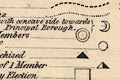
Contributory Borough {with concave side towards Principal Borough.} ... [crescent moon]
Boroughs returning two Members ... [large double circle]
Do. ... ... 1 Do. ... [large circle]
Do. ... wholly Disfranchised ... [black triangle]
Do. ... Disfranchised of 1 Member ... [black and white triangle]
Principal Places of County Election ... [large square]
Polling Places ... [large maltese cross]
Markets Towns, with the distance from London in measured Miles, as ... ANDOVER / 63 1/2
Churches and Chapels ... [cross (+)]
Seats of the Nobility and Gentry ... [outline with fence palings]
Railways ... [bold line, station marked by a bold dot]
Lines for which Acts have been obtained ... [double line]
Turnpike Roads ... [double line, light bold] Bye Roads ... [narrower double line, light light]
Mail Coach Roads ... [double line with dotted line down the middle]
Rivers ... [wiggle line] Navigable Canals ... [triple line, light bold light]
NB. The figures on the Turnpike Roads show the distance in measured Miles between the Towns.
The map shows a great deal of electoral data; as explained in the table of symbols, and more. The county divisions are separated by a dot dash line, and labelled:-
NORTHERN DIVISION
SOUTHERN DIVISIONBoroughs are bounded by a dotted line.
Not all the symbols in the 'explanation' are used in Hampshire. Examples in the county are:-
Winchester :-
a [square] as a principal place of county election; a [double circle] as it returns two members to Parliament; and a [maltese cross] as it is a polling place.
It also has two stars attached. This is an earlier convention for showing that it returned two members to Parliament.
Petersfield :-
lacks a [circle] to show it still returns a member; has a [black and white triangle] showing it is disfranchised of 1 member; and a [maltese cross] for being a polling place.
It has two stars showing it used to return two members to Parliament.
Stockbridge :-
a [black triangle] showing it has been disfranchised.
It has two stars showing it used to return two members to Parliament.
A summary of representation is printed below the title, upper left:-
2 For each Division of County ... 4
2 Do. ... Five Boroughs ... ... 10
1 Do. ... Two Boroughs ... ... 2
Total number of Members ... ... 16
Exclusive of the Isle of Wight.
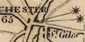
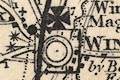
Settlements are shonw by blocks or groups of blocks representing buildings, along roads and streets. In the larger places these make a street plan of sorts. The parish church, or other, even a cathedral, is shown by a drawing of a church symbol, building and tower. Places are graded by the amount of building and their text labels.
city :-
A city is drawn by groups of blocks along streets, the cathedral drawn by building and tower; labelled in upright block caps, eg:-
WINCHESTER [maltese cross and arrow, square, two stars]This city has other churches as well, named, eg:-
St Cross
St GilesWinchester has a maltese cross and arrow indicating that it is a Chief Place of County Election (so is Southampton) and has two asterisks indicating that it returns two members to Parliament. The borough boundary is a dashed line.
town :-
A town is drawn the same way as a as a city. For example, Southampton has all the features that Winchester has.
A smaller town is shown by blocks grouped on streets making a street plan, plus a church shown by a building with a tower; labelled in upright block caps, eg:-
ALTONThis town has a maltese cross to show that it is a Polling Place.
Parliamentary divisions and boroughs are bounded by a dot dash line, and each area has a tint on the inside of its boundary. At this date, about 1900, the areas are as follows.
Divisions:-
N. OR BASINGSTOKE [orange]
E. OR PETERSFIELD [green]
S. OR FAREHAM [magenta]
W. OR ANDOVER [pink]
NEW FOREST [yellow]and the Isle of Wight, pink.
Boroughs:-
Portsmouth
Southampton
Winchester
ChristchurchA total of 12 members of Parliament.
Printed lower towards the right is an:-
EXPLANATION
The Police Divisions are distinctly coloured.
The broad blue belt is the boundary of the Northern and Southern Divisions.
The thin blue lines are the Boundaries of the Parliamentary Boroughs.
Railways & Stations [bold line, circles beside line]The Police Divisions have dashed boundaries which are tinted differently. The areas are numbered, keyed to a table of data:-
THE PETTY SESSIONAL & POLICE DIVISIONS
are coloured distinctly, and the LARGE FIGURES near the centre of each correspond with the FIGURES in the following List if these Divisions, so that their names may be readily ascertained on the Map.
1 Alton
2 Andover
3 Basingstoke
4 Droxford
5 Fareham
6 Kingsclere
7 New Forest and Lymington
8 Odiham
9 Petersfield
10 Ringwood
11 Romsey
12 Southampton
13 Winchester
14 Isle of Wight
The 38 HUNDREDS and 12 LIBERTIES into which Hampshire is divided were amalgamated and arranged in the above named DIVISIONS in 1834.Printed on the right is more descriptive text and tables:-
HAMPSHIRE AND THE ISLE OF WIGHT had 405,370 inhabitants in 1851: they extent over 1070,200 acres: the rateable annual value of their lands and buildings is about L1,514,100.
PARLIAMENTARY DIVISIONS & BOROUGHS
The broad blue belt extending across the county is the boundary of the NORTHERN and SOUTHERN DIVISIONS, each of which sends two Members to Parliament. THE ISLE OF WIGHT sends one member as a separate county or division. The BOROUGHS are WINCHESTER CITY, PORTSMOUTH, SOUTHAMPTON, ANDOVER, LYMINGTON and NEWPORT each sending two, and Christchurch and Petersfield each sending one member.
COUNTY POLLING PLACES.
NORTHERN DIVISION
WINCHESTER, Alton, Whitchurch, Andover, Bishopstoke, Bishops Waltham, Kingsclere, Odiham, New Alresford, Petersfield
SOUTHERN DIVISION
SOUTHAMPTON, Fareham, Gosport, Havant, Lymington, Portsmouth, Ringwood, Romsey
FOR THE ISLE OF WIGHT,
Newport, Cowes and Ryde.
The boundary of the two electoral divisions of Hampshire is a thin dotted line. (I think.)
Printed lower left on the north sheet is:-
The North Division of Hampshire returns 2 Members of Parliament for the Division, 2 each for the Boroughs of Winchester & Andover & 1 for Petersfield.A corresponding summary is not given on the south sheet, which has a more detailed statement in descriptive text, qv.
The county boundary is a bold line, the county area, Hampshire, is printed yellow; the detached part of the county S of Haslemere is not shown (has it gone by 1868?). Adjacent counties, uncoloured, are delimited by a dot dash line and labelled, eg:-
WILTSHIREThe boundary of the N and S divisions of the county, set up during parliamentary reform is a dotted line. This is overshadowed by the division, printed in bold red, of the county into 6 areas (including the Isle of Wight), labelled in red:-
ANDOVER
BASINGSTOKE
PETERSFIELD
FAREHAM
LYMINGTON
ISLE OF WIGHTThe division boundary is near but not the sanme as the relevant red boundaries.
The county boundary is a dotted line, tinted. Adjacent counties are labelled, eg:-
WILTSHIRESome places, roads, and railways are shown outside Hampshire for the sake of continuity.
Note that the electoral boundary between North Division and South Division is the same sort of line; the two divisions labelled '1' and '2'.
A dot dot dash line divides the county into two large electoral areas:-
NORTH DIVISION
SOUTH DIVISION

Dotted lines then divide the areas into 'divisions' labelled 1..14 (including the Isle of Wight), the numbers explained in a table printed lower left:-
References to the Divisions
1 Odiham
2 Basingstoke
...
13 Ringwood
...The borough areas are bounded by dashed lines. Printed lower right is:-
The County returns to Parliament 4 members
The Borough of Andover ... 1 Do.
... ... Lymington ... 1 Do.
... ... Portsmouth ... 2 Do.
... ... Southampton ... 2 Do.
... ... Winchester ... 2 Do.
... ... Christchurch ... 1 Do.
... ... Petersfield ... 1 Do.
... ... Lymington ... 1 Do.
... ... Lymington ... 1 Do.
The boundary between thirteen parliamentary divisions is a dot dot dot dash line. The two main divisions are labelled:-
NORTHERN DIVISION
SOUTHERN DIVISIONcoloured pale green and yellow respectively. A red circle under the name of the division indicates the number of members returned to Parliament. The divisions are divided into hundreds, by a dotted line; note that parts of a hundred might be in different divisions. The hundred areas are labelled by a number referring to a table printed lower left:-
The LARGE FIGURES in body of Map refer to the DIVISIONS, HUNDREDS, and LIBERTIES, thus;-
ODIHAM DIVISION.
Crondal ... 1
Odiham (part of) ... 2
Holdshot do. ... 3
Bermondspit do. ... 4
Bentley ... 5
BASINGSTOKE DIVISION.
Holdshot ... 6
Barton Stacey ... 7
Overton ... 8
Chuteley ... 9
Basingstoke ... 10
Bermondspit ... 11
Odiham ... 12
KINGSCLERE DIVISION.
Evinger ... 13
Chuteley ... 14
Kingsclere ... 15
Basingstoke ... 16
Overton ... 17
Pastrow ... 18
ANDOVER DIVISION.
Andover Hund. ... 19
Pastrow ... 20
Thorngate ... 21
Kings Sombourn ... 22
Buddlesgate ... 23
Wherwell ... 24
Barton Stacey ... 25
ROMSEY DIVISION.
Thorngate ... 26
Kings Sombourn ... 27
Buddlesgate ... 28
Mansbridge ... 29
Redbridge ... 30
New Forest ... 31
WINCHESTER DIVISION.
Buddlesgate ... 32
Barton Stacey ... 33
Micheldever ... 34
Mainsboro' ... 35
Bountisboro' ... 36
Fawley ... 37
Bishops Waltham ... 38
ALTON DIVISION.
Fawley ... 39
Bishops Sutton ... 40
Shaldon ... 41
Alton ... 42
Selbourn ... 43
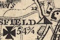
PETERSFIELD DIVISION.
Barton Stacey ... 44
Fawley ... 45
East Meon ... 46
Alton ... 47
Odiham ... 48
Finch Dean ... 49
FAREHAM DIVISION.
Portsdown ... 50
Bosmere ... 51
Havant Lib. ... 52
Fareham Hd. ... 53
Gosport & Alverstoke ... 54
Titchfield ... 55
DROXFORD DIVISION.
Bishops Sutton ... 56
Fawley ... 57
Meon Stoke ... 58
Hambledon ... 59
Bishops Waltham ... 60
SOUTHAMPTON DIVISION.
Mansbridge ... 61
Bishops Waltham ... 62
Baddlesgate [sic] ... 63
Dibden ... 64
Beaulieu .. 65
LYMINGTON DIVISION.
Christchurch ... 66
Ringwood ... 67
New Forest ... 68
RINGWOOD DIVISION.
Christchurch ... 69
Westover ... 70
Ringwood ... 71
Fordingbridge ... 72
New Forest ... 73
Breamore ... 74
ISLE OF WIGHT.
West medina ... 75
East do. ... 76Boroughs, towns sending members to parliament, are bounded by dotted line and tinted pink (I think).
Settlements are marked by blocks or groups of blocks, differentiated by style of lettering, and a number of added elements.
city :-
group of blocks at the confluence of roads; labelled in upright block caps:-
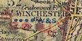
WINCHESTER / 63Winchester has a red maltese cross for a cathedral city; is underlined by four blue dots to show it is a post town; has a red sword as a place where county courts are held; has a red square for a place where quarter sessions are held; has two red dots indicating it is a parliamentary borough returning two members to Parliament; and has blue letters for market days:-
W & SWednesday and Saturday.
The figure is the distance from London. The various added elements are not always easy to read, getting lost in the detail on the map.
town :-
group of blocks; labelled in upright block caps, eg:-
Alton / 47with four blue dots for a post town; red sword for county courts; and letter:-
Tufor Tuesday market day.
SOUTHAMPTON / 74has four blue dots, two red dots, a red sword, letter F? for Friday market day; and is underlined in blue to show it has a population over 50,000.
PORTSMOUTH / 70has four blue dots, red sword, two red dots, market days:-
Tu Th & Sand is underlined in red for a population above 100,000.
The electoral divisions of the county are bounded by dotted lines, with an orange tint. The six areas are palely coloured: N - yellow; E - green; W - pink; S - violet; New Forest - yellow. The areas are labelled with their name, eg:-
N. OR BASINGSTOKEAt the front of the atlas are various lists of electoral data:-
A LIST OF THE PARLIAMENTARY BOROUGHS.showing the number of members returned to Parliament.
...
Christchurch ... 1
Portsmouth ... 1
Southampton ... 2
Winchester ... 1and:-
LIST OF THE COUNTY DIVISIONS, According to the Redistribution Bill, 1885, each Division returning 1 Member.
...
HAMPSHIRE -
N. or Basingstoke
E. or Petersfield
W. or Andover
S. or Fareham
New Forest
Isle of Wight
...
Settlements are shown by a small group of blocks, differentiated by style of labelling. There might be a cross (+) for a ?church.
The distance of towns from London is given; and stars are attached to borough towns for the number of members they return to Parliament.
city :-
labelled in upright block caps:-
WINCHESTER / 62 [2 stars]
town :-
labelled in upright lowercase text, eg:-
Southampton / 75 [2 stars]
Petersfield / 54 [1 star]
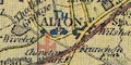
Alton / 47
Stockbridge / 66
Dotted boundaries tinted orange divide the county into electoral ?divisions, each with a colour tint for the area:-
Northern or Basingstoke
Western or Andover
Eastern or Petersfield
Southern or Fareham
New ForestDashed boundaries tinted orange delimit the larger boroughs, each tinted pink:-
Winchester
Southampton
Portsmouth
Christchurch
electoral data |
|||||||||||||||||||||||||||||||||
| electoral data |  |
 |
 |
 |
|
|
|
|
|
|
|
|
|
|
|
|
|
|
|
|
|
||||||||||||
| asterisks for MPs | |
|
|
|
|
|
|
|
|
|
|
|
|
|
|
|
|
|
 |
|
|
||||||||||||
| MPs (not asterisks) | |
|
|
|
|
|
|
|
|
||||||||||||||||||||||||
| divisions etc | |
|
|
|
|
|
|
||||||||||||||||||||||||||
| polling places etc | |
|
|
|
 |
||||||||||||||||||||||||||||
