
 Return to list of Features

NB: typical illustrated examples are described, NOT ALL examples.
absence of evidence is not evidence of absence
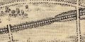
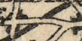
When the Old Series was first published there were no railways. Railways were added on later printings by a double line with cross lines, often labelled with a version (not reliable) of the railway's name. Cuttings and embankments are shown by hachures; over and under bridges indicated; viaducts drawn with a row of v pillars and label 'Viaduct'; tunnels shown by a double dotted line and label 'Tunnel'; stations drawn by a block or two and label 'Station' or 'Railway Station'. Looking closely at the engraving it is possible to see how the engraving is added to an existing plot.
The Map Collection does not have a set of sheets of one period, so it is not sensible to survey railways as a whole for the county. An example from sheet 11 is:-
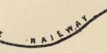
London and Southampton Railway :-
passing on the west side of Winchester, where there is a:-
Stationthen down the Itchen valley, 'Station' outside Bishopstoke; and on to:-
Railway Stationat Southampton. The line is labelled:-
Southampton and London railwayThere are figures beside some lines, eg:- 80, 81, ... starting at Southampton along the Southampton and Dorchester Railway. These are probably distances from London.
There are two tables printed on the right of the map, a list of:-
RAILWAYSwhich at this early date is short, and has nothing in Hampshire. And:-
A LIST OF THE CANALS & NAVIGABLE RIVERS SHEWING THE PRINCIPAL ARTICLES OF MINERAL TONNAGEwhich includes, for Hampshire:-
Canals ... ... ... ... Article of Tonnage
...
Andover ... w ... ... ... Coal
...
Basingstoke ... w ... im ... Coal
...and:-
...
Avon R. (Salisbury) 50M. ... Coal, Gun Flints
...
Itching R. ... 15M. ... ... Coal
...
The table of symbols includes a symbol for railways; there were no railways in Hampshire till 1830s, the first opened 1838.
There were no railways when the map was drawn about 1830. Railways are drawn by a bold line with cross ties. The engraving is done crudely, running over existing features and labelling. It is not all done in the same style, which hints that railways might have been added bit by bit. A few of the lines are labelled; lines going out of the county are labelled with their destination. The railways shown are (the list terms are the standard terms used in Old Hampshire Gazetteer, the date is the date of opening):-
London and Southampton Railway :-
1840labelled:-
London & Southampton Raily.
Bishopstoke to Gosport branch railway :-
1842
Chichester to Portsmouth branch railway :-
1847labelled at the county boundary:-
To Chichester & Brighton
Eastleigh to Salisbury branch railway :-
1847labelled at the county boundary:-
From Salisbury
Southampton and Dorchester Railway :-
1847labelled at the county boundary:-
Fr. Dorchester
Berkshire and Hampshire Railway :-
1848labelled at the county boundary:-
To Reading
Fareham to Cosham branch railway :-
1848
Reading, Guildford and Reigate Railway :-
1849labelled at the county boundaries:-
Fr. Reading / To Reigate
Farnham to Alton branch railway :-
1852
Bishopstoke and Salisbury Railway :-
1857labelled at the county boundary:-
From Salisbury
Lymington Railway :-
1858
Ringwood, Christchurch and Bournemouth Railway :-
1862as far as Christchurch
Mid Hants, Alton Lines, Railway :-
1865?drawn as a proposed line?
Salisbury and Dorset Junction Railway :-
1866labelled at the county boundary:-
From Salisbury
Southampton and Netley Railway :-
1866As far as 'Nelley' only.
Railways have been added to the later edition of the map, drawn by a bold line with cross ties. The engraving runs over existing features and labels. The railway shown is:-
London and Southampton Railway :-
Opened throughout 1840, labelled:-
Southampton Railway
Railways are drawn by a double line with cross ties. The lines are engraved over existing features on the map, obscuring features and labels willy-nilly. The original map, 1833, had no railways. Later maps have more railways as a broad bold line:-
A single railway is shown on the map, labelled:-
London and South Western Raily.When the map was made, 1835, the London and Southampton Railway had not been built, though its route was known from its Act of Parliament passed 1834. It was renamed the London and South Western railway in 1839, and opened throughout in 1840.
In 1838 there no railway had been completed in Hampshire, but the London and Southampton Railway, later the London and South Western railway, LSWR, was being built. Its Act passed in 1834, so its route was known and is shown on this map by a double line with cross bars. It is labelled:-
Southampton and London RailroadAlthough the branch to Gosport was known in 1838 it is not suggested.
In places the railway looks as of it is added, it is engraved over other features, elsewhere a label is fitted to the line of rail, suggesting the label came after the railway.
A railway is drawn by a line with cross lines, a convention that is still familiar today. The one line is the:-
London & Southampton Railwaywhich was partially open in 1839, and became the London and South Western Railway later that year (?). It was opened throughout in 1840. This line is engraved on the old plate, and obscures yet more stuff on the original map.
The first railways in Hampshire are shown, overprinted in red, named in black engraved text; stations labelled:-

StationTwo railways are shown (remember that the routes are declared and authorised earlier than the date of opening):-
London and Southampton Railway :-
opened 1840; from Surrey near Farnborough, stations at Winchfield, Basingstoke, near Popham ie Micheldever, Winchester, and Southampton.
London & Southwestern Railway
London and Southampton Railway :-
opened 1842; from a junction at Bishopstoke, through Fareham to Gosport; no stations marked.
Gosport Junction Railway
Railways are drawn by a double line with cross lines, and labelled:-

Chichester and Brighton Railway
Southampton and Gosport
Southampton and Brighton Railroad
Railways were very new to Hampshire when this map was published. Two lines are shown:-
London and South Western Railwayie the London to Southampton line, shown from near where it enters the county to about Bishopstoke. And:-
Gosport Junction Railwaythe Bishopstoke to Gosport branch railway.
Railways are drawn by a broad bold line; stations marked by a bold dot. Lines to be built are shown by a double line. The railway might be labelled. The completed railways in the county are:-
London and Southampton Railway, 1840, labelled:-
South Westn. Ry.Bishopstoke to Gosport branch railway, 1842
Chichester to Portsmouth branch railway, 1847
Eastleigh to Salisbury branch railway, 1847
Southampton and Dorchester Railway, 1847
Berkshire and Hampshire Railway, 1848
Fareham to Cosham branch railway, 1848
Lines in progress are:-
Reading, Guildford and Reigate Railway, 1849, labelled:-
Reading, Guildford, & Reigate Raily.Farnham to Alton branch railway, 1852
Basingstoke and Salisbury railway, 1857
Portsmouth Railway, 1859, labelled:-
Portsmouth Raily.Andover and Redbridge Railway, 1865
The map is fairly uptodate with railways.
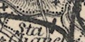
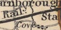
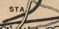
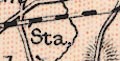
Railways are shown by a bold line overlaying all other features on the map. Stations are marked as:-
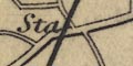
Sta.which is Micheldever Station on the London and Southampton Railway. Some stations are not marked, for instance those at Winchester and Gosport.
A planned route, or one being built, is shown by a bold dashed line, as from Basingstoke to Salisbury.
One of the map's owners has extended the line from Farnham on to Alton, New Alresford and Winchester. Then crossed the last section out and drawn it to join the London and Southampton Railway near Kings Worthy.
Railways are shown by a bold solid line, some labelled with a name. The railways shown are:-
SOUTHAMPTON RAILWAY [London and Southampton Railway, 1840]
... [Bishopstoke to Gosport branch railway, 1842]
HANTS & BERKS RAILWAY [Berkshire and Hampshire Railway, 1848]
SALISBURY RAILWAY [from Romsey this is the Eastleigh to Salisbury branch railway, 1847]
DORSETSHIRE RAILWAY [Southampton and Dorchester Railway, 1847]
... [Fareham to Cosham branch railway, 1848]
PORTSMOUTH EXTENSION [Chichester to Portsmouth branch railway, 1847]The Eastleigh of the Salisbury line, above, is missed out, and a line shown from Romsey to Redbridge. This line was not built until 1865, a part of the Andover and Redbridge Railway. The line to Alton, opened 1852, is not shown. The Basingstoke to Salisbury line was being built, having been authorised in 1846, and is not shown. There may be other planned and/or authorised railways not shown.
Railways are added to the map, engraved over and obliterating some original features. They are shown by very bold solid lines with large dots for stations, with equally bold dotted lines for routes 'in progress' which may or may not have happened:-
Routes are labelled in bold upright block caps along the lines, eg:-
SOUTH WESTERN RAILWAY MAIN LINEfor the London and Southampton Railway which had become the London and South Western Railway, LSWR, in 1839. Stations are also labelled in bold upright block caps, eg:-
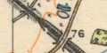
WINCHESTER STA.
ANDOVER JUN STA.Tunnels are shown by a double dotted line, the width matching the width of the bold solid line, labelled:-
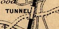
TUNNELfor example, north of Micheldever Station.
A thorough analysis of the railways might be interesting. At least one of the lines in progress was never built, that shown from Petersfield to Bishops Waltham.
Railways are drawn by a bold solid line; stations have a small dot and are labelled:-
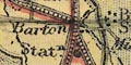
Staexcept a few named stations, eg:-
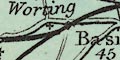
Sway StaThe important junction to the west of Basingstoke is labelled:-
Worting JunctionThe bold line of the railway become an unfilled double line where it might interfere with existing labels on the map. Railways will have been added throughout the life of the map's engraved plate. The railways shown are listed below with their original name and date of opening, and their map label if there is one:-
London and Southampton Railway (1840) :-
London & South Western Raily.
Bishopstoke to Gosport branch railway (1842) :-
Chichester to Portsmouth branch railway (1847) :-
Brighton Railway
Eastleigh to Salisbury branch railway (1847) :-
Southampton and Dorchester Railway (1847) :-
London & South Western Raily.
Berkshire and Hampshire Railway (1848) :-
Reading Branch
Fareham to Cosham branch railway (1848) :-
Reading, Guildford and Reigate Railway (1849) :-
Reading & Reigate Raily.
Farnham to Alton branch railway (1852) :-
Alton Branch S.W. Raily.
Basingstoke and Netley railway (1857) :-
Salisbury and Andover Branch
Lymington Railway (1858) :-
Portsmouth Railway (1859) :-
Direct Portsmouth Raily.
Ringwood, Christchurch and Bournemouth Railway (1862) :-
Bishops Waltham Railway (1863) :-
Stokes Bay Railway and Pier Co (1863) :-
Petersfield Railway (1864) :-
Andover and Redbridge Railway (1865) :-
Mid Hants, Alton Lines, Railway (1865) :-
[Alton Branch S.W. Raily.]
Salisbury and Dorset Junction Railway (1866) :-
Hayling Railway (1867) :-
Swindon, Grafton and Marlborough Railway (1882) :-
Didcot, Newbury and Southampton Railway (1885, 1891) :-
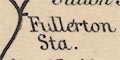
Hurstbourne and Fullerton branch railway (1885) :-
Brockenhurst to Christchurch branch railway (1888) :-
Southampton and Netley Railway (1889) :-
Lee-on-the-Solent Light Railway (1894) :-
? :-
branch railway from Fratton to Southsea
This includes railways built up to 1894, and does not include railways opened from 1901 onwards.
Railways are drawn by a bold smooth line sweeping across the landscape, passing under and over roads. This line is not added over everything else willy-nilly as on some maps; it is part of the original engraving. Some railways are named. The following railways can be recognised (the 'modern' names are the identifying names used in Old Hampshire Gazetteer), date order:-
London and Southampton Railway :-
open as the London and South Western Railway, 1840, labelled:-
SOUTHAMPTON AND LONDON RAILWAY
Bishopstoke to Gosport branch railway :-
open 1842.
Eastleigh to Salisbury branch railway :-
open 1847.
Southampton and Dorchester Railway :-
open 1847.
Berkshire and Hampshire Railway :-
open 1848, labelled:-
BASINGSTOKE AND READING RAILWAY
Chichester to Portsmouth branch railway :-
open 1848, labelled:-
SOUTH COAST RAILWAY
Fareham to Cosham branch railway :-
open 1848.
Reading, Guildford and Reigate Railway :-
open 1849, labelled:-
READING AND REIGATE RAILWAY
Farnham to Alton branch railway :-
open 1852, labelled:-
ALTON BRANCH
Basingstoke and Salisbury Railway :-
open 1857.
Lymington Railway :-
open 1858.
Portsmouth Railway :-
open 1859, labelled:-
PORTSMOUTH DIRECT RAILWAY
Andover and Redbridge Railway :-
open 1865, authorised 1858, labelled:-
REDBRIDGE AND ANDOVER RAILWAY (late Andover Canal)still drawn as the canal.
... :-
outwith Hampshire; Reading, Newbury, Hungerford; labelled:-
BERKS AND HANTS OR GREAT WESTERN RAILWAY
... :-
outwith Hampshire; London to Bristol line through Reading; labelled:-
GREAT WESTERN RAILWAY
Railways are the subject of the maps. Railways are drawn by a double line with cross lines; some lines are in broken stretches, presumably lines still being built. Lines are labelled. Stations are marked by a spot, generally labelled:-
Sta.Lines shown in Hampshire are listed below (lines outwith the county ignored). Some are shown on separate sheets, and labelled more than once. The railways are listed under their original name; the labelling reflects the way the various routes were considered by the LSWR at this later date.
London and Southampton Railway :-
1840
LONDON & SOUTH WESTERN RAILWAY
SOUTH WESTERN RAILWAY / LONDON & SOUTHAMPTON BRANCH
Bishopstoke to Gosport branch railway :-
1842
GOSPORT JUNCTION RAILWAY
PORTSMOUTH BRANCH
Chichester to Portsmouth branch railway :-
1847
PORTSMOUTH, CHICHESTER & BRIGHTON RAILWAY
Eastleigh to Salisbury branch railway :-
1847
SALISBURY BRANCH RAILWAY
Southampton and Dorchester Railway :-
1847
SOUTHAMPTON & DORCHESTER RAILWAY
LONDON & SOUTH WESTERN RAILWAY / SOUTHAMPTON & DORCHESTER BRANCH
Berkshire and Hampshire Railway :-
1848. Great Western Railway.
BASINGSTOKE & READING BRANCH
Fareham to Cosham branch railway :-
1848 Labelled on Gosport branch part.
PORTSMOUTH BRANCH
Reading, Guildford and Reigate Railway :-
1849.
SOUTH EASTERN RAILY. READING & REIGATE BRANCH
Farnham to Alton branch railway :-
1852
SOUTH WESTERN RAILWAY. ALTON BRANCH
Basingstoke and Salisbury Railway :-
1857
ANDOVER & SALISBURY BRANCH
Lymington Railway :-
1858. Unlabelled branch from outside Brockenhurst, to Lymington
Ringwood, Christchurch and Bournemouth Railway :-
1862. Only as far as Christchurch, unlabelled.
Stokes Bay Railway and Pier Co :-
1863. Unlabelled branch from outside Gosport to Stokes Bay.
Bishops Waltham Railway :-
Dotted line, unlabelled, from a junction at Botley, through Bishops Waltham. Opened 1863.
Andover and Redbridge Railway :-
Dotted line, unlabelled, from Redbridge through Romsey running north; not shown at Andover. Opened 1865.
Mid Hants, Alton Lines, Railway :-
Dotted line, unlabelled, from a junction near Headbourn Worthy, running east. Dotted line running south west from Alton. Opened 1865.
Salisbury and Dorset Junction Railway :-
Dotted line, unlabelled, from junction west of Salisbury, running south. Opened 1866.
The railways shown suggest a date for the map about 1863.
Railways are drawn by a line with cross lines. Some are labelled. Stations are mostly taken for granted, but notice:-
Dock Sta.at Southampton. Not all tunnels are noticed, but the two N of Winchester are labelled:-

tunnelwritten across the line, which is not hidden or dotted.
The railways shown are:-
SOUTH WESTERN RY. [London and Southampton Railway, 1840]
SALISBURY AND EXETER BRANCH [Basingstoke and Salisbury Railway, 1857]
GOSPORT JUNCTION RAILWAY [Bishopstoke to Gosport branch railway, 1842]
SOUTHAMPTON AND DORCHESTER RAILWAY [Southampton and Dorchester Railway, 1847]
... [Eastleigh to Salisbury branch railway, 1847]
... [Portsmouth Railway, 1859]
... [Farnham to Alton branch railway, 1852]
... [Fareham to Cosham branch railway, 1848]
... [Chichester to Portsmouth branch railway, 1847]which suggests a date for the map about 1860.
Railways are drawn by bold lines. Stations are marked by a bold rectangular spot. These are more prominent than is necessary for a gelogical map; but it must be remembered that the geology is added to an existing map that specifically advertised its coverage of roads and railways.
Lines under construction are meant to be shown by a double line; the bold line without its fill. This is according to the table of symbols. In practice the lines in progress seem to be alternately filled/unfilled lines, for example around Whitchurch.
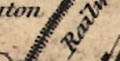
Railways are drawn by a bold line with cross lines, the same convention used by the OS Old Series maps.. The line might be labelled, eg:-
London & Southampton Raily.The destination of lines outwith the county might be labelled, eg:-
To Reigate
from Salisbury
To Reading
Railways are drawn by a double line with cross lines. Many lines are labelled, eg:-
London and South Western Railway
Gosport & Portsmouth BranchA black rectangle on the line marks a:-
Statn.
Railways are drawn by a line with cross lines.
Railways are a clear feature of this map. Some are labelled with their name, eg:-
L. & S. W. Raily.And, like the roads, are labelled at the edges of the sheet with a destination, eg:-
To London
L. & S. W. Railwy. (from Dorchester)
Direct Portsmth. Raily. (to London)Stations are marked with a dot by the line, and labelled:-
St.One station, distant from any settlement, is labelled more:-
Beaulieu Rd. Stn.
Railways are marked by a bold line. Cross lines are used to mark the position of a station, as explained in the table of symbols. Hampshire has no lines 'in progress'. In Hampshire the following lines can be recognised, in date order:-
London and Southampton Railway, 1840
Bishopstoke to Gosport branch railway 1842
Chichester to Portsmouth branch railway 1847
Southampton and Dorchester Railway 1847
Berkshire and Hampshire Railway 1848
Reading, Guildford and Reigate Railway 1849
Farnham to Alton branch railway 1852
Basingstoke and Salisbury Railway 1857
Lymington Railway 1858
Portsmouth Railway 1859
Bishops Waltham Railway 1863
Petersfield Railway 1864
Andover and Redbridge Railway 1865
Mid Hants, Alton Lines, Railway 1865
Salisbury and Dorset Junction Railway 1866
Southampton and Netley Railway 1866 (NOT the extension to Fareham 1889)
Ringwood, Christchurch and Bournemouth Railway 1862 and 1870The names are those used in the directory of railways in the Old Hampshire Gazetteer, with the dates of opening.
The Hayling Railway 1867 and Stokes Bay Railway 1863 are missing, otherwise all railways up to 1870 are shown. The Didcot, Swindon and Southampton Railway, authorised in 1873, is not shown as a line in progress. Allowing for mistakes it seems the map dates from the period 1870-75.
Railways are drawn by a chequered double line.
Railways are drawn by a bold line. From the way the engraving overruns existing place names, etc, though the line is modified not to obscure these labels, it could be that railways have been added to an earlier engraved plate. Stations are marked by a dot and labelled:-
STAThe railways shown in Hampshire are:-
London and Southampton Railway :-
1840
LONDON & SOUTH WESTERN RAIL
Bishopstoke to Gosport branch railway :-
1842
Chichester to Portsmouth branch railway :-
1847
BRIGHTON & CHICHESTER RAILWAY
Eastleigh to Salisbury branch railway :-
1847
SALISBURY RAILWAY
Southampton and Dorchester Railway :-
1847
SOUTHAMPTON & DORCHESTER RAILWAY
Berkshire and Hampshire Railway :-
1848
BERKS AND HANTS RAILWAY
Fareham to Cosham branch railway :-
1848
Reading Guildford and Reigate Railway :-
1849
READING AND GUILDFORD RAILWAY
Farnham to Alton branch railway :-
1852
Basingstoke and Salisbury Railway :-
1857
Lymington Railway :-
1858
Portsmouth Railway :-
1859
Ringwood, Christchurch and Bournemouth Railway :-
1862
Bishops Waltham Railway :-
1863
Stokes Bay railway and Pier Company :-
1863; the pier is drawn and labelled
Pier
Petersfield Railway :-
1864
Andover and Redbridge Railway :-
1865
Mid Hants, Alton Lines, Railway :-
1865
Salisbury and Dorset Junction Railway :-
1866
Southampton and Netley Railway :-
1866; not as extended to Fareham (1886)
Hayling Railway :-
1867
There is no hint of the Didcot, Newbury and Southampton Railway or Swindon, Grafton and Marlborough Railway both authorised in 1873.
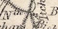
According to the table of symbols, railways are drawn by a triple line, tinted red. In practice the railways are drawn by a pair of double line, the rails, with cross lines for the sleepers. In places the cross lines have been forgotten; in other places the triple line is used. The red tint is printed out of registration.
Stations are marked by a dot, and labelled, eg:-
Station
Statn.
Sta.A railway might be labelled, eg:-
London & South Western Ry.
Railways are shown by a bold line, with a line across at stations; railways appear an important feature of the map. Some are labelled with the railway name, eg:-
London & South Western Raily.and some are labelled outside the county with their destination, eg:-
From Trowbridge &c.
To LondonThe map includes:-
London and Southampton Railway - 1840
Bishopstoke to Gosport branch railway - 1842
Chichester to Portsmouth branch railway - 1847
Eastleigh to Salisbury branch railway - 1847
Southampton and Dorchester Railway - 1847
Berkshire and Hampshire Railway - 1848
Fareham to Cosham branch railway - 1848
Reading, Guildford and Reigate Railway - 1849
Farnham to Alton branch railway - 1852
Basingstoke and Salisbury Railway - 1857
Lymington Railway - 1858
Portsmouth Railway - 1859
Bishops Waltham Railway - 1863
Stokes Bay Railway - 1863
Petersfield Railway - 1864
Andover and Redbridge Railway - 1865
Mid Hants, Alton Lines, Railway - 1865
Salisbury and Dorset Junction Railway - 1866
Southampton and Netley Railway - 1866
Hayling Railway - 1867
Ringwood, Christchurch and Bournemouth Railway - 1870
Swindon, Grafton and Marlborough Railway - 1883
Didcot, Newbury and Southampton Railway - 1885
Hurstbourne to Fullerton branch railway - 1885which is uptodate.
A few railways are drawn by a double line, slightly broader than that for roads. These are quite well hidden amongst the other stuff on the map, but can be recognised if you know where railways ran. Although the map seems to have been issued about 1890, only two railways are shown in Hampshire:-
London and Southampton Railway :-
coming into the county south of Frimley, going round the north side of Basingstoke, turning southward past Winchester, to Southampton. This is the main LSWR line.
Bishopstoke to Gosport branch railway :-
from the LSWR, passing Botley and Fareham, to Gosport.
Railways appear to be an afterthought; and incomplete afterthought.
Railways are drawn by bold lines if they are part of the postal system, otherwise by light double lines, and by light dotted lines if they are in still course of construction. The railways (not their companies) shown in use are:-
Andover and Redbridge Railway
Basingstoke and Salisbury Railway
Berkshire and Hampshire Railway
Bishops Waltham Railway
Bishopstoke to Gosport branch railway
Brockenhurst to Christchurch branch railway
Chichester to Portsmouth Railway
Eastleigh to Salisbury branch railway
Fareham to Cosham branch railway
Farnham to Alton branch railway
Hurstbourne to Fullerton branch railway
London and Southampton Railway
Lymington Railway
Mid Hants, Alton Lines, Railway
Portsmouth Railway
Reading, Guildford and Reigate Railway
Ringwood, Christchurch and Bournemouth Railway
Salisbury and Dorset Junction Railway
Southampton and Dorchester Railway
Southampton and Netley Railway
Stokes Bay Railway and Pier
Swindon, Grafton and Marlborough Railway
Railways are drawn by a chequered double line. The network includes the segment from Chesil Station, Winchester, south to join the London to Southampton Railway, which was opened 1891. It does not show the Meon Valley Line or the Basinsgtoke and Alton Light Railway, built in the 1900s.
Railways are drawn by a chequered double line, labelled with the railway company name, eg:-
L.& S.W.R
S.E. & C.R.Stations are marked by a block, labelled:-
Sta.Railway bridges over the road are drawn with an archway; under the road no bridge is drawn. Railways for Hampshire are listed below.
Railways are clearly drawn by a bold line with cross lines. In Hampshire the lines built up to 1905 can be recognised, but not the line built in 1925.
The London and South Western Railway, LSWR, dominates the map with a network of bold red lines. Solid lines for existing railways, dotted lines for railways authorised or being constructed. In Hampshire two lines are dotted:- the Bentley to Bordon Light Railway, which opened 1905 and was extended by the Longmoor Military Railway, 1906; and the Totton, Hythe and Fawley Light Railway, which opened 1925.
Note that some routes in the west country are supplemented by coach routes, drawn by a double red line. For example from Tavistock to Liskeard.
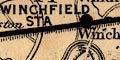
Stations are marked by a red dot; labelled in red upright block caps. The lettering size shows the importance of the place, eg:-
WINCHESTER [large]
SOUTHAMPTON [large]
BASINGSTOKE [medium]
WINCHFIELD [small]At the bottom there is a list of:-
LONDON STATIONS, WATERLOO, LUDGATE VAUXHALL & KENSINGTON.
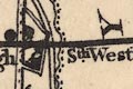
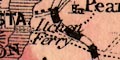
Railways are drawn by a bold black line, stations marked by a circular or rectangular dot. Stations not labelled by a settlement name are labelled in italic lowercase text, eg:-
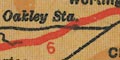
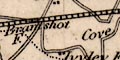
Oakley Sta.
Fleet Sta.
Railways are drawn by a double line. This has the appearance of being engraved after other features. It sometimes goes under a road, sometimes across, but never over.
Stations, according to the table of symbols, are wherever a locomotive is drawn. (I have not checked the correspondence of symbols and stations).
A tunnel might be shown by the railway disappearing into a portal, appearing again from another.
Some railways are labelled, eg:-
L. & S. W.
Example:-
... pass under railway bridge ...
The table of symbols provides a whole lots of conventions for representing railway lines, from mainline railways to mineral lines and tramways. Main lines are labelled with the railway company name, perhaps abbreviated. The scale of the maps allows some suggestion, perhaps unrealistic, of detail, eg:-
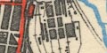
S.R. Worksshowing part of the London and Southampton Railway, the junction with the Bishopstoke to Gosport branch railway, and Eastleigh Works of the London and South Western Railway, LSWR. And more anonymously:-
cutting and embankment drawn by hachures, over bridge and under bridge, ... Stations are marked by a red filled rectangle or circle, an uncoloured circle if disused.
The railway is a bold line up the page: stations clearly marked and labelled in underlined upright block caps, eg:-
WINCHESTERThe distance of each station from London, Waterloo, is given at the side of the map. The time from station to station is also given (one assumes for a non-stop train). For eaxmple Winchester is:-
66 3/4 MILES FROM LONDON
12 MINUTES MICHELDEVER TO WINCHESTER
4 MINUTESto Shawford.
Features of the line, embankments, cuttings, tunnels, bridges are shown and sometimes labelled, eg:-
deep Cutting
Bridges overAlso notice:-
Railway Worksdrawn with a mass of sidings and sheds at Eastleigh.
Altitude figures are given along the line. A gradient diagram shows the altitude of the line as a graph alongside the strip maps. The diagram is annotated, eg:-
LINE LINE FALLS 1:100
LINE RISES STEEPLY 1:80
LINE LEVELThere are comments about the speed on the journey, eg:-
Speeds: The slight rise in level through Basingstoke does not affect our speed, and we bowl along at 60 m.p.h. increasing on the down gradient through Overton ... ...
railways |
|||||||||||||||||||||||||||||||||
| railways |  |
|
|
|
|
|
|
||||||||||||||||||||||||||
As long as the multiple dates for the 'existence' of a railway are recognised, they can be a useful dating tool for a map. There is a published list of Hampshire railways:-
Norgate, Martin: 2002: Hampshire Railways: Hampshire CC Museums Service

