
 Return to list of Features

NB: typical illustrated examples are described, NOT ALL examples.
absence of evidence is not evidence of absence
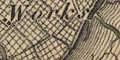
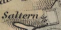
A couple of miles west of Lymington there are drawn rows of rectangular ponds, the salterns, labelled:-
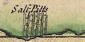
Salt Pitts
Salt pans are shown near Lymington.

On the coast is a rectangular bondary line with small square ponds, salt ponds, labelled:-
Saltsworks
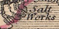
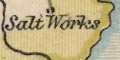
Just by Lymington is:-
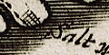
Saltworks
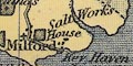
Along the shore between Lymington and Milford are small buildings labelled:-
s.h.a note printed below the descriptions of tides tells us:-
N.B. the Letters s.h. where ever they occur stand for Salt Houses.There are numerous windmills, drawn as post mills, with the salterns. On Portsea Island, north east coast, are:-
Salt Pans
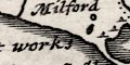
Salt workslabelled south of Milford. Are the little lumps meant to be piles of salt?
South west of the Lymington river is a row of inverted V symbols, perhaps piles of salt, with a label west of Hurst:-
Salt Works
The chart studied has detailed mapping of salterns along the coast west of Lymington along towards Hurst. The drawing seesm to show enclosed salt pans areas, numerous windpumps, and works buildings.
The salterns along the coast by Lymington are shown by a row of windmills and buildings, labelled:-
Salt Houses
Salterns are marked by an outline with diagonal cross hatching, often labelled, eg:-
Bounds Saltern [E of Fawley]
Great Saltern [no symbol, E coast of Portsea Island]and a large area of hatching:-
Salt Workson the coast between Lymington and Milford. There salterns, larger and smaller, all along the coasts of the islands and mainland from Langstone Harbour to beyond Lymington.
Salterns are marked by an outline with cross hatching representing the salt pans. ON the coast by Lymington a large area of salt pans is labelled:-

SALT WORKSelsewhere these are labelled:-
Saltern
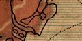
Shaded areas south west of Lymington are labelled:-
Salt Works
Outlines and labelled on the coast south of Lymington is:-
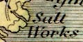
Salt Works
South west of Lymington the salterns are drawn, but not labelled:-
On the west bank of the River Hamble is:-
Salt Pansand on the east:-
Old salt HouseOn Portsea Island there are:-
Salternsby Salterns Farm on the east shore. On Hayling Island's east shore are:-
East Saltern
West Saltern
Salterneach with a windmill, for pumping brine, and with a clear salt pan at the last.
A couple of blocks, for a small settlement or buildings, are labelled:-
Salt Worksbetween Lymington and Milford.
There are ponds on the coast between Lymington and Keyhaven, labelled:-
Salt Works
The Lymington salterns are not noticed, but elsewhere there are:-
salternslabelled with no special symbol, as on the east shore of Hayling Island, and:-
Bounds Salternon Southampton Water near Fawley.
On the coast between Lymington and Milton are:-
Salt Works
In the coastal area south west of Lymington is;-
Salt Works
: 1766: Museum Rusticum et Commerciale: (London): vol.1: pp.272-294
King, Edward: 1972: Walk through Lymington: Kings of Lymington (Lymington, Hampshire):: chapter 5 - Manufacture of Salt
Lloyd, Arthur T: 1996 (reprint): Salterns of the Lymington Area: Buckland Trust (Lymington, Hampshire)
