
 Return to list of Features

NB: typical illustrated examples are described, NOT ALL examples.
absence of evidence is not evidence of absence

The sea is painted green(ish). The sea area to the south labelled:-
mare australe
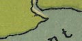
southern seaThe Isle of Wight is clearly drawn off the Hampshire coast; and smaller islands might be:-
Portsea Island
Hayling Island
Sea areas are partly shaded, and there is a label:-
OCEANUS GERMANICUSfor the sea north of Scotland.
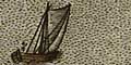
The sea is stipples; the coast a bold line. The English Channel is labelled:-
MARE BRITANNICUA[]There are a few ship for decoration.
The Solent
Southampton Water
Portsmouth Harbourcan be recognised.
The sea area is pecked. There are a few ships for decoration. The English Channel is labelled:-
OCEANUS BRITANNICUSA sandbank is shown by dotting on the NE shore of the Isle of Wight in The Solent.
It is possible to recognise:-
The Solent
Southampton Waterbut these are not labelled.
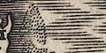
The sea is engraved with a pecked pattern

and is decorated with ships - carracks, and a few monstrous fish. Sea areas are labelled, eg:-
OCEANUS BRITANNICUSFor the English Channel.
The sea to the south of the county is stippled.
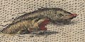
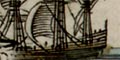
In the sea are various ships, small coastal craft and two carracks of the period. A couple of unlikely fish are drawn as well.
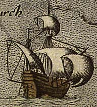
The hull of the smaller carrack is clearly pointed at one end and flat at the other, where there is a stern rudder. It has two masts and a bow sprit: main mast and main topmast with square main sail and main topsail; mizzen mast with a lateen sail; bow sprit with a square sail.
The larger carrack looks more fierce to this lubberly eye, with fore and stern castles of several stages. It has 3 masts and bowsprit: fore main and fore top masts with square sails; main and main top masts with square sails; mizzen mast with a lateen sail; bow sprit with a square sail. Ratlines can be seen on the main mast rigging.
Most of the small coastal vessels have spritsails; one has a square sail.

The sea is engraved with a pecked pattern. There is a monstrous fish west of Ireland; and a fishing scene in the North Sea. The sea area south of Hampshire is labelled:-
Britannicus oceanus
The sea area is stippled and tinted blue;
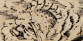
The sea is busy with ships, from a rowing boat off Cornwall about Padstow, to 3 masted carracks. Enormous fishes swim in the sea.

Neptune with crown and trident, and a nymph of course, grace the Irish Sea.
The main sea areas are labelled, eg:-
OCEANUS BRITANNICUS.Sea areas relevant to Hampshire which can be recognised easily are:-
Solent
Southampton water
(Treatment of the sea area can't be seen clearly.) The sea is labelled:-
THE CHANELL BETWEENE ENGLAND AND FRAUNCEThere are depth soundings in the sea area, presumably in fathoms, ranging from 2 close to shore to 35 out in the channel.
Sandbanks are indicated between the Isle of Wight and the mainland.
Anchorages are shown by a ships anchor (upsidedown?) in the sea between the Isle of Wight and Southampton Water, and at Spithead, etc.
The sea is engraved with a moire effect.
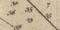
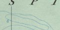
The sea is pecked, and tinted blue. Sea areas are not labelled. Some sandbanks are drawn by dotting, and at least one is labelled:-
Owerseast of the Isle of Wight, which was significant to the Armada operation. A rock is marked by a cross (+), labelled:-
Edy stone
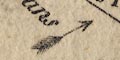
The sea is painted a dark blue-green, decorated with ships. For example, off Kent there is a three masted 'galleon'; spritsail, fore mast with main and top sails, main mast with main and top sails, mizzen mast with a lateen sail, and various flags.

The sea is engraved with a moire effect. A sandbank is shown as a dotted area off the east coast of Kent.
The sea between England and France is:-
OCEANUS BRITANNICIUSand either the sea area, or the nearby headland, is labelled:-
The Beacheoff Beachy Head.
The sea is engraved with a moire effect pattern. The Solent is labelled:-

PARTE OF YE BRITISH SEA
Off Hurst there is a large fishes's head and about Spithead can be seen the ghostly remains of an erased engraving of a galleon, perhaps making space for the sea area label.
The sea area is stippled; some sea areas are labelled, eg:-
OCEANUS BRITANNICUSfor the English Channel. The sea is decorated with a few ships, sea nymphs blowing horns, and, lower right, Neptune on a horse holding a trident, accompanied by a nymph, of course.
There is some attempt at moire effect sea.
The sea is pecked. A number of ships decorate the sea area; and there is a monstrous fish N off the Isle of Wight.
The sea is plain, and has been tinted blue. Sea areas are labelled:-
THE DEUCALIDON SEA
THE IRISH SEA
THE BRITISH SEA
THE WEST OCEAN
THE GERMAN OCEANThe last two in florid swash lettering to fill otherwsie empty space on the map.
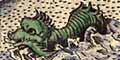
The sea is decorated with a couple of ships, sea monsters, and 'royal beasts' carrying flags of the three nations of Great Britain.
The ships are crudely drawn two masted carracks. That on the left seems to have pointed ends, not a flat stern with rudder. Three ships' flags appear to be the flag of Aragon, Spain, horizontal bands, red yellow red (but we don't know who coloured the map or when).
Three of the monsters in the sea are interesting. There is a lion carrying the standard of England; a unicorn carrying the standard of Scotland; and some other mythical beast carrying the standard of Ireland.
The sea is drawn with a moire effect.

The sea is engraved with a moire effect pattern.
The sea area is plain and the coast line shaded for emphasis.
The sea is plain with depth soundings in fathoms, sandbanks dotted and rocks drawn as little triangles, and anchorages shown by an anchor symbol.
The English Channel is labelled:-
LA MANCHE Sive HET CANAAL.The coast line is shaded and tinted inland.
The sea is plain, with depth soundings in fathoms and sandbanks dotted. Rocks are shown by crosses or little triangles, as at the Needles. The Shingles can be recognised. A row of posts, 'dolphins', are marked on a sandbank at Rye.
Anchorages are shown by an anchor symbol; and some leading lines are drawn.
The sea area is plain, with some sea areas labelled, eg:-
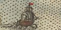
Spitt headin this area there are moored two 3 masted ships, their sails furled.
The sea area is plain.
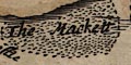
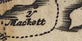
Sandbanks are indicated by pecked areas in the sea, one is labelled:-
BLA1COA2.jpg
The Mackettoff Hayling Island.
Sea areas may be labelled, eg:-
OCEANUS / BRITANNICUSand are decorated with ships:-
The small amount of sea are on the map is plain. The sea between the Isle of Wight's coast and the mainland is labelled:-
THE BRITISH SEAand

Titchfield Bayis labelled.
A few sandbanks, off Hayling Island, in Langstone Harbour, and the Hurst and Calshot spits are dotted.
The sea is plain with depth soundings in fathoms. Foreshore and sandbanks are shown as dotted areas. The Shingles can be recognised. Rocks are drawn as crosses, or drawn as rocks. Anchorages are marked by an anchor symbol.
There is a ship for decoration, a 3 masted merchantman.
The sea area has shading lines in places, perhaps just to make it less 'empty'. One sea area is labelled - The Solent, called:-
PART OF YE BRITISH SEASouth of Hayling Island is a sandbank:-
The Mackett
The sea area is plain, decorated with some sea monsters and a few ships. Some of the main sea areas are labelled, eg:-
OCEANUS BRITANNICUS / THE CHANNEL
The sea is plain; some sea areas are labelled, eg:-
THE BRITISH OCEAN OR CHANNEL
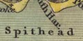
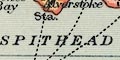
Spithead
The sea are is plain. The main sea areas are labelled, eg:-
THE CHANNEL
The sea is plain. The sea between the Isle of Wight and the mainland is labelled:-
THE BRITISH SEAThe sandbank off Hayling is drawn in outline with a dotted line and labelled:-
Y Mackett
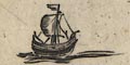
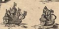
A single ship decorates the sea; round bodied, one square sail; it might be possible to make more guesses about the type of ship but these would be very rough - it's a carrack.
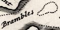
The sea is plain, with depth soundings in fathoms, tidal streams with arrows and times, sandbanks dotted, a few leading lines, and a very few anchorages shown by an anchor symbol. It is possible to recognise some sandbanks in the Solent area:-
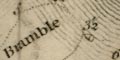
Bramble
Middle
Shingles
Horse and Dean SandsMost of the labelling in the sea are is in Dutch.
The sea is plain, the sea area in the south labelled:-
OCEANUS BRITANNICUS Versus GALLIAMThere are some 3 masted ships, men of war, in the sea, for decoration.
The sea is plain. Some sea areas are labelled, eg:-
THE CHANNEL
Spithead
THE BRITISH OCEAN vulgo THE NORTH SEAsandbanks are shown by dotted areas. There are many off the german coast and off East Anglia. They might be labelled, eg:-
The Dogger BankAn unlabelled sandbank west of the Isle of Wight may be The Shingles, and another west of the island, the Owers. Rocks may be marked by crosses (+) for example around Garnsey and the:-
Bogher Rocksoff Sussex.
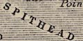
The sea rae is pecked. Where there is a sandbank it is shown by more dense pecking, perhaps labelled, eg:-
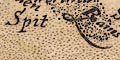
SpitThe sea area at the entrance to Portsmouth Harbour is labelled:-
Spit HeadA sandbank off the S of Hayling Island is added, shown by denser pecking.
The whole coast line of the Isle of Wight is redrawn. This involved re-engraving some of the 'pecking' of the sea, and Hurst Castle.
The Channel is labelled:-
LE CANAL OU LA MANCHEThe sea is plain with depth soundings, sandbanks dotted, and rocks shown by little triangles.
The sea is plain. Hurst and Calshot spits are shown as sandbanks.
The moire effect engraving of the sea area has been erased.
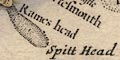
A sandbank, shown by pecking, is added off Rames Head; the sea area labelled:-
Spitt head
There is explanatory text printed centrally
In this Channell Draught, the smaller Figures are the Depth in Fathoms. The Litteral or Roman Figures shew ye Hour of High-Water, or rather ye End of the Stream that setts to ye Eastward, on ye Day of ye New & Full Moon. Add therefore ye time of the Moons Southing or Northing to ye Number found near ye place where your. Ship is, & ye Sun shall show you how long ye Tide will run to ye Eastward. But if it be more than 12 Subtract 12 therefrom. The Direction of ye Darts shew upon what Point of ye Compass ye Strength of ye Tide sets. All Masters of Ships and others, who shall have oppertunity to observe ye Depths, with Certainty in respect of ye Place, are desired to communicate them to ye Publisher hereof.
The sea is plain, some areas labelled, eg:-
THE BRITISH CHANNEL
THE STREIGHTS OF DOVER
SpitheadSome ships are drawn for decoration; for example a 3 masted ship with 2 gun decks off Cuckmere, and a galley with a square sail off Rye.
A few sandbanks are shown as dotted areas, for example at the Thames mouth.
The sea area is plain, with one area labelled:-
THE CHANNEL
The sea is plain, with some sea areas labelled, eg:-
THE ENGLISH CHANNEL
Hampton Water
The sea is plain; some sea areas are labelled, relevant to Hampshire are:-
Trisanton Aestuar [= Southampton Water]
OCEANUS BRITANNICUS
[greek = Magnus Portus]
The sea areas are plain. Some sea areas are labelled, eg:-
OCEANUS BRITANNICUSfor the English Channel.
The sea is plain; some sea areas are labelled, eg:-
ENGLISH CHANNEL
Spit Head
Southampton WaterThere are a few sounding lines, dotted, marking the foreshore and sandbanks. A couple of ?shoals are labelled in The Solent:-
Brambles
Midle
The sea is plain with some sea areas labelled, eg:-
THE ENGLISH CHANNEL
The sea area is plain, with seas labelled, eg:-
THE ENGLISH CHANNELThe distance from Dover to Calais, 22 [miles], is shown in the strait.
The sea is plain. A few sea areas are labelled:-
THE CHANNEL
St. Hellens Road
Hampton Water
The sea are is plain. Either side of the Isle of Wight the sea is labelled:-
ENGLISH CHANNELThe sea area from the mouth of the Test to the sea is:-
Hampton WaterAlso see
Spit HeadThe foreshore mud or sand flats and some sandbanks are shown by a dotted outline, some labelled, eg:-
Brambles
Middle
The sea is plain.
Spit Headlabels either the headland or the sea area offshore. This sea area is labelled:-
St Helen's Roadleading into:-
CHANNEL
The sea is plain, and has a scatter of depth soundings, presumably in fathoms. Some sea areas are labelled, eg:-
CHANNEL
Tor BaySandbanks are shown by dotted areas. In the Hampshire area there are:-
Shingels
Middle / OwersThe Middle sandbank in The Solent can be recognised, and the shallows off Portsea Island. Foreshore shallows are indicated by a dotted line in The Solent and Southampton Water. The harbours of Portsmouth, Langstone and Chichester are recognisable, but not labelled.
Crosses (+) are used to mark rocks. To the west of the Isle of Wight are three dots labelled:-
Needles
The sea is plain, with few sea areas labelled, eg:-
ENGLISH CHANNEL
Spit Head
The sea is shaded by horizontal lines.

Off the west coast is labelled:-
The English Channel
Spit Headis labelled, and:-
St Helen's Roadis labelled off the east of the Isle of Wight
There are various square rigged ships in the seas.
The sea is plain. Some sea areas are labelled, eg:-
Haling Bay
Spit Head
ENGLISH CHANNEL
The sea area is plain. Labelled at the south edge of the map is:-
ENGLISH CHANNEL
The sea is shaded and tinted blue (or the coast is shaded far out from land). Some sea areas are labelled, eg:-
Southampton [Southampton Water]
Spithead
Sea areas are plain, and might be labelled, eg:-
Baye Stokes
Spit Head
Baye HalingThe sea area is marked with depth soundings in fathoms and quarters or halves, as noted in the Remarks. The soundings extend into harbours as at Lymington, Portsmouth, etc.
Shallows, sandbanks etc, are indicated by a dotted line, which does not seem to be a depth contour, or by dotted areas. These might be labelled, eg:-
Christ Church Ledge
Singles Banc [Shingles]
Brambles
Midleor described, eg:-
Bas fond toujours couvert d'eau [Horse and Dean Sand]Buoys are drawn, a conical shape, or just labelled, marking some shallows. For example:-
Spit Bouee [on unlabelled Spit Sand]
Le Cheval Bouee [SW corner of Horse and Dean Sand]
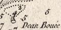
Dean Bouee [ - ditto - ]There are a few indicators of tide times, eg:-
IX h 1/2in the Solent at the entrance to Southampton Water, and:-
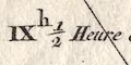
IX h 1/2 Heure de la Pleine Merin the eastern approaches, east of Bembridge and St Helens.
A few anchorages are indicated by a fisherman's anchor symbol, for example in Sandown Bay, and at:-
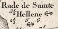
Rade de Sainte Helleneoff the east of the Isle of Wight; but none in the Solent.
A wreck is indicated by a buoy name:-
Edger Boueeat Spit Head in the Solent; the wreck of HMS Edgar which blew up and sank 1711.
The sea area is plain, and filled with descriptive texts! Some sea areas are labelled, eg:-
ENGLISH CHANNEL
Christ Church Bay
SOUTHAMPTON WATERand note particularly:-
Spit Head and St. Helen's, are the general Rendezvous of the Royal Navy.Some sandbanks are drawn in outline with a dotted line.
Same as Kitchin (as far as I can see); sand banks tinted.
The sea is plain, with some areas labelled, eg:-
Spithead
Haling Bay
Southampton Water or Trissanton BaySandbanks are indicated by a dotted outline, but none labelled.
The sea is plain; some sea areas are labelled, eg:-
ENGLISH CHANNEL
Spithead
The sea area is plain.
Pecking is used to show foreshore shallows and sandbanks, the pecking denser at the edges. The spit off Blockhouse Point is labelled:-
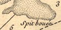
Spit boueAnd the large shallows off the south of Portsea Island:-
Bas fond toujours couvert de la Mer
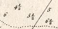
The sea and channels are labelled with depth soundings,eg:-
6
3 1/2which are most likely in fathoms.
The sea area is plain, tinted blue. Some sea areas are labelled, eg:-
ENGLISH CHANNEL
Christ Church Bay
St. Hellens Road
Spitheadcontinued with a descriptive note
& St. Hellens are ye General Rendezvous of the Royal NavySome sandbanks, the Bramble for instance, are indicated by dotted lines; not labelled. Rocks might be indicated by crosses (+) off the shore, labelled:-
Benbridge Ledge
Atherfield RocksBoth on the Isle of Wight.
The sea is plain. Some ares are labelled, eg:-
ENGLISH CHANNEL
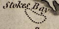
Stokes Bay
Southampton Water or Trisanton BayForeshore shallows and sandbanks are shown by a dotted outline and some are labelled, eg:-
Christ Church Ledgewhich could be The Shingles. Also:-
Bramble Dry
MiddleTwo buoys are drawn as conical shapes, named:-
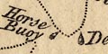
Horse Buoy
Dean Buoy
The sea is plain; some sea areas are labelled, eg:-
ENGLISH CHANNEL
Spit Hd.
The sea is plain, with some labelling, eg:-
ENGLISH CHANNEL
STR. OF DOVER
Race of Portland
The sea is plain, some sea areas labelled, eg:-
ENGLISH CHANNELA few sandbanks are drawn by a dotted outline, and might be labelled, eg:-
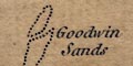
Goodwin SandsA lighthouse might be shown, eg:-
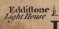
Eddistone / Light Housea tower on its rock.
The sea is plain, with some sea areas labelled, eg:-
ENGLISH CHANNEL
Spit Head
Depth soundings, in fathoms, are printed over the sea areas. Most of these do not come close to the coasts, and only become interesting in the channels of clusters of sandbanks in the narrows between England and France, the Thames estuary, and the islands off the Flanders coast.
Tidal streams are marked by arrows, or darts. And times of high water are given by roman numbers, eg:-
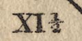
XI 1/2This is explained lower left:-
The small figures express the depth of water in fathoms.
The Roman figures indicate the time of High water, or rather the end of the Stream setting Eastward on the New & Full Moon.
The Darts shew the direction of the currents produced by the Tides.Some sandbanks are shewn as dotted areas, perhaps, labelled. Relevant to Hampshire for example:-
Shinglesand less easily read:-
Middle BankNotice the:-
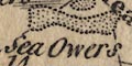
Sea Owers labelled south of Selsey. Rocks might be shewn by crosses (X) as at:-
Barn Rockseast of Selsey.
Depth soundings are marked all over the sea areas, into channels and river mouths.There is an explanatory (beware my translation may not be perfect):-
Note
The figures of soundings are given in english fathoms bigger then french by 1/8.
The letters by the figures mark the nature of the bottom as;reverting to French:-
S. Sable, V.S. Vase et Sable, Gr. Gravier, V.Gr. Vase et Gravier, Gr.S. Gravier et Sable, S.Gr. Sable Gravier, Coq. Coquilles, Gr.Coq. Gravier et Coquilles, S.Coq. Sable et Coquilles, R. Roches.The terms seem to translate as follows; Sable - sand, Gravier - gravel, Vase - mud, Coquille - shell, Roches - rocks.
Examples:-
3 5/6 Gr.
4 1/6 S.There are dotted lines which seem to be depth contours.
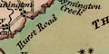
Sea areas are not named, but some of the river channels have labels, for example up the Lymington River entrance are:-
Long Reach
Skort Reach (sic)
Horn ReachAnchorages are marked by an anchor symbol. There might be helpful; comment, eg:-
Here is the best anchorage of the Yarmouth RoadsSandbanks are outlined by dotted lines in sea areas, and might be labelled or described, eg:-
Mineway (off Milford)
Tres mauvais Mouillage - Very bad anchorage (off Yarmouth)
A number of sea marks are drawn explicitly; a light at Hurst Castle, a conical buoy off the end of Warden Ledge off the Isle of Wight, and markers (balise) at the entrance to Lymington River, one labelled (in English):-
Jack in the BasketThe beacon at the east end of the Isle of Wight is described more fully:-
The light at Needle Point is at 445ft; ground level 415ft, plus 30ft height of the buildingLand features, church towers, windmills, hill tops, headlands, etc, are also used to define leading lines. These lines usually have navigation instructions on them, (check modern sailing directions before trusting my translation) eg:-
You must enter by the North Channel holding Scone Point very little apart from Hurst Point.
At various positions in the sea areas the direction of the flooding tide is given by an arrow, with its direction, and sometimes comments about the strength, eg between Hurst Castle and Round Tower Point:-
N.E. 1/4 N 5[degrees] N. Speed 5 Spring Tides 3 1/2 Neap TidesThe terms in French are:-
G.M. - Grandes Marres
M.E. - Mortes Eaux
(page 10/104 scroll 4 mile 75)The small amount of sea, at Southampton, is plain, labelled:-
The Sea
The sea is plain with depth soundings in fathoms. Sand banks are shown by a dotted outline, rocks by crosses and inverted vees. Some anchorages are shown by anchor symbols.
The sea is plain. The sea area
Spitheadis labelled, also:-
Southampton Water / Trisanton Bay
The sea is plain. Some sea areas are labelled, eg:-
ENGLISH CHANNEL
The SOLENT
Christchurch Bay
SOUTHAMPTON WATER
The sea area is plain with some labelling, for example:-
Stokes Bay
ENGLISH CHANNEL
Spithead
Southampton Key or Trisanton BaySandbanks and shallows are suggested by a dotted line offshore in the sea which is otherwise plain.
The sea are is plain. The only sea area labelled is:-
Hayling BaySandbanks are outlined by a dotted line, and might be labelled, eg:-
Mother Bank
THE HORSE / Loose Shifting Sand / THE DEANBuoys are drawn, looking like a conical buoy? Some are named and described, eg:-
Nomardsland Buoy
Warner Buoy / Whiteon the starboard side of the eastern approach channel leaving Spithead, and a series of buoys on the south east corner of Horse and Dean Sand, marking the port side of same route:-
Horse Buoy / Black
Elbow Buoy / Black
Third Buoy / Black
Fourth Buoy / Black
Outer Buoy / Black
The sea is plain. South of the Isle of Wight is labelled:-
ENGLISH CHANNELThe Solent is labelled:-
THE INNER PASSAGE (ie The Solent)And other sea areas are:-
CHRISTCHURCH BAY
SOUTHAMPTON WATERA couple of sandbanks are marked north of Cowes.
The sea area is plain. Some sea areas are labelled, eg:-
Christchurch bay
Spithead
The sea is plain; some sea areas are labelled, eg:-
ENGLISH CHANNEL
SPITHEAD
Southampton Water
The sea area is plain, tinted pale blue for a distance off shore. The main sea areas are named by Ptolemy, eg:-
BRITANNICUS OCEANUSfor the English Channel.
The sea is plain. A few sea areas are labelled, eg:-
CHRISTCHURCH BAY
SOUTHAMPTON RIVER [ie Southampton Water]
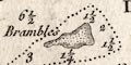
Hayling BayIn The Solent and its approaches there are depth soundings, figures in fathoms, eg:-
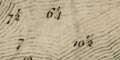
7
6 1/4One anchorage is marked by an anchor symbol, labelled:-
St. Helens Road.Some of the well known shallows are indicated by a dotted outline, perhaps labelled, eg:-
The Shingles
Bramble
Middle
Spitbank
THE HORSE
THE DEANThe last two being described as:-
Loose Shifting SandOff the entrance to Chichester Harbour the shallows are drawn as islands.
Although not labelled, quite hard to notice, there are buoys marked by the Bramble and Middle banks. A sequence of buoys is marked along the south west edge of the Horse and Dean Sands, labelled:-
Dean Buoysand individually with name and colour:-
Horse Buoy / black
[second buoy not labelled]
Third Buoy / black
Fourth Buoy / black
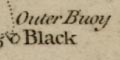
Outer Buoy / blackThe symbol for a buoy suggests the conical shape typical for these markers at the time. There are other names buoys, eg:-
Edgar Buoywhich marks the wreck of the 3rd rate ship HMS Edgar, 70 guns, launched 1709, which blew up and sank, 15 October 1711.
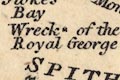
Off the entrance to Portsmouth Harbour in Spithead is:-
Wreck of the Royal Georgenear a sounding for 13 fathoms.
A leading line is drawn for the eastern approach channel, labelled:-
Fort Monckton and Kickergill in one.
The sea area is plain, but littered with useful navigational information.
Some sea areas, channels, etc are named, eg:-
Christ Church Bay
SPITHEAD
Langstone ChannelSandbanks are clearly shown by dotted areas, the density of dotting suggesting the different depths of the hazard. The presence of rocks below or above water (at low water?) is shown by rock symbols. Many of the hazards are named, eg:-
HORSE DEAN
Bramble
Christ Church Ledgeand some have helpful descriptions, eg:-
Mud
Dry at Low Water
Shifting Ground
Breakers
Dry at EbbThere are symbols for buoys, labelled with its colour; red, white, or black. Many of these mark sandbanks, for example the Bramble has a red buoy at its west end, a white at the east.
A buoy might have a name, eg:-
Outer Buoyon the Horse Sands, and:-
Spitin Spithead.
A buoy might mark a wreck, which is named, eg:-
R. George
Edgarfor wrecks off Spithead. HMS Edgar, 3rd rate ship of the line, 70 guns, blew up and sank, 12 October 1711. HMS Royal George, flagship of Admiral Kempenfelt, sank while her hull was being repaired, 1782.
Off the coast near the Bramble is:-
overfallsDepths of water in fathoms at low water are given over the whole sea area, out to about 20 fathoms. Deeper parts are just given in fathoms; shallower soundings are given more accurately, to the half fathom. Soundings continue into harbours and up rivers to 1 fathom. There is no attempt to show depth contours.
Anchorages are indicated by an anchor symbol; the flukes facing left, down, or right. (What does this mean?) There might be added information, eg:-
good anchoringin Christchurch Bay These symbols do not appear in estuaries and harbours, where anchorage is taken for granted?
The chart has information on tidal streams and the times of high water. Arrows show the direction of flow of the stream on the flood, ie an incomimg tide. In the Solent there is added:-
Velocity 3 Spring Tides
2 NeapThese are presumably in knots.
(There is nothing to suggest double tide effects in the Solent/Spithead.)
Times of high water are given at various places by roman number, for hours, perhaps with arabic figures for parts of an hour, eg:-
IX [Christchurch Bay]
VIIIh.56' [SW of The Needles]
XI 3/4 [Southampton Water]The chart does not say what reference place is taken for the time of high water to which these times are comparitive.
The likely interpretation for a map of this period was given by Cmdr John Page, tidal branch of the Hydrographic Office, Taunton. The times given are the 'high water lunitidal interval'. The time of high water is given as the time in hours and minutes after the transit of the moon at the Greenwich meridian.
Prominent features on land are used as sea marks by which leading lines are drawn across sea areas by a double line. The land features are labelled, and there might be other useful information.
For example two forts:-
Kicker
Moncton Fortdefine a leading line labelled:-
The Kicker and Moncton Fort in oneie sighted in line. Or, an unnamed windmill NW of Hamble, and a building:-
Hook Summer Housedefine a leading line labelled:-
Clears the BrambleLeading lines enable the mariner to gauge his position relative to visible features on the coast avoiding hidden dangers below. All this if there is visibility.
The sea is plain.
The sea area is plain, some areas labelled, eg:-
ENGLISH CN[ ]the remainder cut off by the dissection, and:-
SpitheadSouthampton Water is clearly recognisable.
The sea is tinted plae blue. Some sea areas are labelled, eg:-
ENGLISH CHANNEL
SPITHEAD
SOUTHAMPTON WATER
The sea is plain; some sea areas are labelled, eg:-
ENGLISH CHANNEL
Southampton W.
Spithead
The sea area is plain, with some areas labelled, eg:-
STOKES BAY
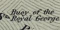
SPITHEADbuoys are not marked generally, but a conical buoy is drawn in Spithead, labelled:-
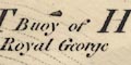
Buoy of the Royal Georgewhich ship sank in 1782 and was still obstructing shipping in The Solent to the mid 19th century.
The sea are is plain; some sea areas are labelled, eg:-
ENGLISH CHANNEL
SOLENT
SPITHEAD
Southampton Water
The sea area is tinted blue. Some ares are labelled, eg:-
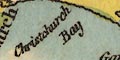
Christchurch B
ENGLISH CHANNEL
SPITHEADThe tint is clearly done fairly crudely at some speed; overlapping the land, missing estuaries, etc. The tint in Portsmouth Harbour is missed completely - on this copy of the map.
The sea area is plain with some areas labelled, eg:-
ENGLISH CHANNEL
Christ Church Bay
The SOLENT
The sea area is plain, with some areas labelled, eg:-
ENGLISH CHANNELSome shipping routes are marked by a dotted line, labelled, eg:-
to Jersey 35 Leaguesfrom Poole.
The sea area is plain, tinted a colour that has degraded into a pale muddy bluey green, rather unattractive. Some sea areas are labelled, eg:-
ENGLISH CHANNEL
SPITHEAD
Hurst Road
Dibden BayFew marine features are drawn, but one sandbank:-
Mother Bankoff the Isle of Wight, and:-
Wreck of the Royal Georgelabelled, and perhaps marked by a buoy?
The sea is shaded. Sea areas are not labelled.
The sea is plain. A few sea areas are labelled, including, off Hampshire:-
SPITHEAD
The sea area is plain; some sea areas are labelled:-
ENGLISH CHANNEL
Christchurch Bay
SPITHEAD
Southampton water
The sea area is plain, though the coast form lines extend far into the offing. Some sea areas are labelled, eg:-
SPITHEAD
SOUTHAMPTON WATERThere is little detail in the sea area, but in Spithead there is the:-
Buoy of the Royal Georgewhose wreck is marked by a conical buoy. The ship sank in the late 18th century and was still a hazard to shipping in this busy road till the mid 19th century. Other buoys are shown in Southampton water, eg:-
Hythe Buoy
Weston Lodge BuoyShallows are mostly ignored, this map is not a chart, but some extensions of the foreshore are shown, as at the Winners off Langston Harbour. Some sandbanks are shown in Southampton water, eg:-
The Gymph
The Bar
The sea area is plain, though the coast formlines extend some way out to sea. Sea areas migt be labelled, eg:-
SOUTHAMPTON WATER
THE SOLENT
SPITHEAD
THE ENGLISH CHANNEL
Stokes BayOutlines of sandbanks are shown by a dotted line in the sea mostly between the Isle of Wight and the mainland. These might be labelled, eg:-
Horse Sand
The sea is plain. Some sea areas are labelled, eg:-
THE SOLENT
SOUTHAMPTON WATER
SPITHEAD
ENGLISH CHANNEL
Christchurch bay
Hurst Road
Dibden BayThe site of the wreck of the Royal George is marked
The sea area is plain; some sea areas are labelled, eg:-
ENGLISH CHANNEL
SPITHEAD
Southampton WaterLarge sandbanks, or shallows, might be drawn in dotted outline, as off Selsey Bill, labelled:-
Owers
The sea area is partly shaded, an extension of the coast shading. Some sea areas are labelled, eg:-
ENGLISH CHANNEL
THE SOLENT
Christchurch Bay
SPITHEADand some of the channels, eg:-
Nth. Channel
Sth. Channelat the western approach to the Solent, by the Needles.
The sea area is plain; some sea areas are labelled, eg:-
ENGLISH CHANNEL
The Solent
Spithead
The sea is plain. Sea areas are labelled, eg:-
Christchurch Bay
THE SOLENT
SPITHEAD
ENGLISH CHANNEL
The sea is plain; some sea areas are labelled, eg:-
ENGLISH CHANNEL
Southampton Water
Spithead
The sea is plain; some sea areas are labelled, eg:-
ENGLISH CHANNEL
North Channel
Stokes Bay
SPITHEADIn Southampton Water, the larger harbours, and off Lymington, there are ?depth contours showing the main channels.
The sea area is shaded, or the coast shading extends far into the sea! Some sea areas are labelled, eg:-
SPITHEAD
Christ Church BayHayling Shoal, off the south of Hayling Island, is outlined by a dotted line.
The sea area is plain, the black background. Some areas are labelled, eg:-
ENGLISH CHANNEL
Southampton Water
SPITHEADHarbours are not particularly noticed, only:-
Portsmh. Harb.is labelled.
The sea is plain. No sea areas are labelled.
The sea is plain; some ares are labelled, eg:-
THE ENGLISH CHANNEL
CHRISTCHURCH BAY
The sea is shaded; some sea areas are labelled, eg:-
ENGLISH CHANNEL
SPITHEAD
SOUTHAMPTON WATER
The sea is plain. Some sea areas are labelled, eg:-
ENGLISH CHANNEL
THE SOLENT
North ChannelThe last being one of the two approaches to the west of The Solent.
The sea is shaded horizontally blue. Some sea areas are labelled, eg:-
ENGLISH CHANNEL
Christchurch Bay
The Solent
Spithead
Southampton Water
The sea is plain. Some sea areas are labelled, eg:-
ENGLISH CHANNEL
THE SOLENT
The sea is plain; some sea areas are labelled, eg:-
ENGLISH CHANNEL
Hurst Road
Christchurch Bay
SOUTHAMPTON WATERSandbanks are not marked, but might be labelled, eg:-
Mother Bankoff the Isle of Wight. In Spithead is labelled:-
Wreck of the Royal Georgewhich sank in 1782 and had been cleared in 1839-40, well before this map was drawn.
The sea area is tinted blue and shaded - or, rather, the coast shading extends far offshore. Some sea areas are labelled, eg:-
ENGLISH CHANNEL
The Solent
Christchurch B.
The sea area is plain, no labelling.
The sea area is tinted by overall shading with blue lines. Some sea areas are labelled, eg:-
ENGLISH CHANNEL
SOUTHAMPTON WATER
Stokes BayFeatures are not marked in the sea except:-
Buoy of the Royal Georgewhich sank in 1782, and whose wreck was mostly cleared away in the mid 19th century because it was a hazard to navigation.
The sea areas are plain; some sea areas are labelled, eg:-
SPITHEAD
Stoke's Bay
SOUTHAMPTON WATER
The sea is plain. Some sea areas are labelled, eg:-
ENGLISH CHANNEL
The Solent
Christ Church Bay
Southampton Water
The sea are is plain; some sea areas are labelled, eg:-
THE SOLENT
Southampton Water
Stokes Bay
The sea area is plain, some areas are labelled, eg:-
ENGLISH CHANNEL
Christchurch Bay
Spithead
The sea area is plain, some areas labelled, eg:-
Christ Church Bay
THE SOLENT
SPITHEAD
The sea area is plain; some ares are labelled, eg:-
The Solent
Stokes Bay
Southampton Water
The sea is plain, printed blue. Some sea areas are labelled, eg:-
The Solent
Southampton Water
Christchurch B.
The sea are is tinted blue, fading to uncoloured far from land. Some sea areas are labelled, eg:-
ENGLISH CHANNEL
The Solent
Spithead
The sea area is plain; some sea areas are labelled, eg:-
The Solent
Stokes bay
Spithead
The sea area is shaded near land; some areas are labelled, eg:-
ENGLISH CHANNEL
SPITHEAD
Stokes Bay
The sea area is printed blue with an array of dots; some sea areas are labelled, eg:-
THE SOLENT
SOUTHAMPTON WATER
Stoke Bay
The sea is colour printed blue; some sea areas are labelled, eg:-
Southampton Water
The Solent
ENGLISH CHANNEL
The sea area is shaded, and some areas are labelled, eg:-
ENGLISH CHANNEL
The Solent
SPITHEAD
Southn. Water
The sea are is shaded blue. Some sea areas are labelled, eg:-
Southampton Water
ENGLISH CHANNEL
Hayling BaySteamer routes to the Isle of Wight are shown by dashed lines; from Lymington to Yarmouth, Southampton to Cowes, and three from Portsmouth and Gosport to Ryde.
The sea is plain with some sea areas labelled, eg:-
NORTH SEA
Straits of Doverand off Hampshire:-
Solent
Spithead
Southampton Water
The sea area is tinted blue.
The sea area is printed blue, with some sea areas labelled, eg:-
The Solent
Spithead
Southampton Water
The sea area is printed blue. Two sea areas are labelled:-
ENGLISH CHANNEL
SOLENT
The sea area on the maps is printed in lighter blue. Some sea areas are labelled, eg (from sheet 132):-
SPITHEAD
THE SOLENT
Stokes BayJohnston 1920:-
... The sea is printed in a solid tint in contrast to the lined efect on the older maps. ...Depth contours are drawn in darker blue at 5 fathom intervals, labelled in fathoms:-
Sandbanks surrounded by water and submarine contours are based upon Admiralty Surveys, the datum of which is approximately Mean Low Water Springs.
The Submarine Contours are given in Fathoms, and are taken from the Soundings of Admiralty Surveys.Sandbanks are mostly not labelled? though on sheet 132 there is:-
Spit Sandlabelled off Haslar, with a buoy at the end, etc. As well a few buoys the maps might show lighthouses or lightships. At Calshot (sheet 132) there are two lights, labelled:-
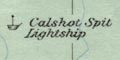
Calshot Spit Lightship
Calshot Lightfloat
The sea is printed blue. Some sea areas are labelled, eg:-
ENGLISH CHANNEL
SPITHEAD
THE SOLENT
Where the sea is shown, at Portsmouth and Southampton for instance, it is plain.
sea area |
|||||||||||||||||||||||||||||||||
| pecked |  |
|
|
|
 |
 |
 |
 |
|
|
|
||||||||||||||||||||||
| moire effect | |
|
|
|
|
|
|
|
|||||||||||||||||||||||||
| shaded | |
|
|
|
|
|
|
|
|
|
|
|
|
|
|
|
|
|
|
|
|
||||||||||||
| coloured | |
|
|
|
|
|
|
||||||||||||||||||||||||||
| plain | |
|
|
|
|
|
|
|
|
|
|
|
|
|
|
|
|
|
|
|
|
|
|
|
|
|
|
|
|
|
|
||
| galleons | |
|
|
|
|
|
|
|
|
|
|
|
|
|
|
|
|
|
|
|
|
||||||||||||
| sea monsters | |
|
|
|
|
|
|
|
|
|
|
|
|||||||||||||||||||||
| wreck of Royal George | |
|
|
|
|
|
|
|
|
|
|||||||||||||||||||||||
Hepper, David J: 1994: British Warship Losses in the Age of Sail 1650-1859: Jean Boudroit Publications (Rotherfield, East Sussex)
Cowper, William: 1782: On the Loss of the Royal George
