
 Return to list of Features

NB: typical illustrated examples are described, NOT ALL examples.
absence of evidence is not evidence of absence
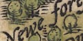
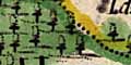
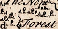
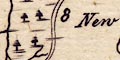
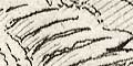
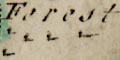
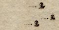
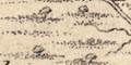
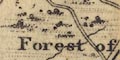
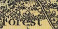
Tree symbols in groups indicate forests. The only one in Hampshire is:-
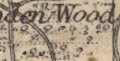
Newe forest
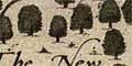
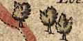
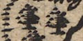
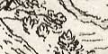
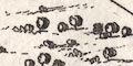
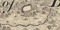
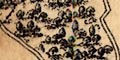
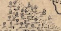
The map has definite groups of trees indicating forests, which are mostly named. The forests mostly correspond to the great hunting preserves declared as royal forests; but not all. Trees are also drawn in parks.
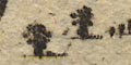
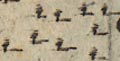
A very few trees symbols suggest woods. These are so crowded out by other features that it is difficult to see that they mean much at all.
There is 1 tree symbol in Hampshire; it is not near any of the old forests.
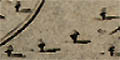
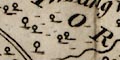
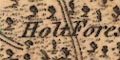
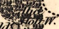
Tree symbols show woody areas (including Woolmer Forest which probably was bare). Some of the old forests are labelled:-
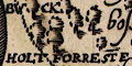
BUCK HOLT FORRESTE
Wutmer FOrrest
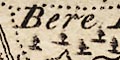
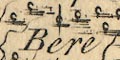
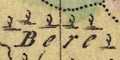
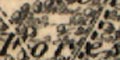
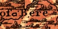
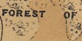
FOREST OF EAST BEARE
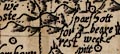
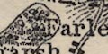
Weste beare forrestThe placement of the labels demonstrates the difficulties of that map making task. If you didn't know that there is a West Bere Forest you might never have associated the detached letters scattered between 'sparshott', 'wecke', 'pitt' and hillock and tree symbols:-
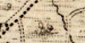
A single tree on a hillock is labelled:-
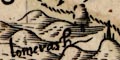
lomerashNW of Exton.
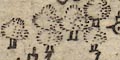
Forests are clearly shown by groups of trees, not named, not even the New Forest. It is possible to recognize most of the forests.
Forests are indicated by groups of outsize pictures of trees.
A number of these are labelled, eg:-
New Forrest
Forrest of Bearewhich is East Bere Forest
Weste Forrestwhich is West Bere Forest
One single tree is named, the:-
Lomer Ash
Scattered in some available spaces there are tree symbols. Looking in Hampshire they suggest wooded areas in the New Forest and Buckholt Forest, but none of the other prominent woodlands. It would take a lot of work to make sense of what is shown; and the labour might be wasted for the symbols might just be filling space.
Overlarge tree symbols suggest woodland, again difficult to judge what is eaningful. Perhaps it is possible to recognise:-
Chute Forest.
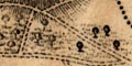
Some of the old forests are shown by groups of relatively large tree symbols. None are labelled, but it is easy to recognise several: New Forest, Buckholt Forest, Chute Forest, West Bere Forest, Pamber Forest, East Bere Forest, and Woolmer Forest.
Tree symbols are used to indicate woodland.
the new foresthas dense groups of trees in parts, as have:-
Walthm Forest
Est. Beare Forest
Chute forestthe last drawn in Wiltshire. North of Liphook is:-
Wulmere forestwithout trees, which is roughly correct.
trees and bushes are grouped to make small landscapes in places on the map, with 'shaded' ground areas. Some groups of trees are labelled, eg:-
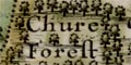
Chure Forest
Beare Forest
NEW FOREST / YTENEThere are also trees in parks.
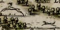
In the New Forest is a nice scene of a deer, stags, being chased by hounds.
There are groups of trees drawn for woodland or forests, some labelled, eg:-
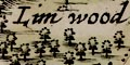
Limwood
Beare Forest [East Bere Forest]
West For. [West Bere Forest]
NEW FORWoodland areas are lightly tinted green.
none
There are tree symbols on the map. The woods New Forest has many; there are a few around Subberton where East Bere Forest could be, some around Braughton which could be Buckholt Forest. But they feel a bit 'accidental'.
A few tree symbols suggest woods, but, as with hillocks, these do not convince the reader of serious intent. In Hampshire there are sprinklings of trees in the New Forest and at Pamber Forest.
Mostly as original.Although it is not needed, a new label:-
NEW FORRESTis added where the trees are most dense, S of Malwood. And there is an added label:-
ArnwoodThe Shire Oak, which was an addition to our copy of Saxton, is erased.
Two definite rows of trees have been added. One from just S of Ewhurst, passing Hannington, to the pass between two hillocks N of Ashe. The other from just E of Wotton running S to a hillock N of Dummer. What interesting details; what are they?
Each settlement is drawn with trees amongst its houses. A few woods are shown as well, some labelled, eg:-
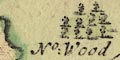
No: Wood
So: Woodon Hayling Island.
Tree symbols are also scattered like decoration. It would be hard to say that any represent the known great forests
Some of the ancient forests are shown by groups of trees. Mostly these are unlabelled, but include Buckholt, Pamber, and East Bere forests and Alice Holt. Labelled is:-
New Forrest
Woods, forests, trees, are not shown. But:-
Test woodis labelled.
There are some tree symbols for woodland and a few hillock symbols for hills. They look to be little more than decoration.
Wooded areas are shown by tree symbols, and might be labelled:-
Kings Forreston the Isle of Wight. On the mainland most woodland is marked along the shore, as is usual for charts.
Either side of Ports Creek at the north of Portsea Island are areas labelled:-
Marsh GroundThese are Farlington Marshes. Other marsh areas are labelled, as are:-
Morasseat Southsea
Furze or Common Groundat south east of Hayling Island
Arable Landat Christchurch, etc.
Clumps of little tree symbols are used to mark woods and forests, perhaps named, eg:_
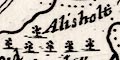
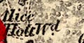
Alisholt Forrest [Alice Holt]
Bere For. [East Bere Forest]
Groups of little trees are used to indicate woods. Only the New Forest and East Beer Forest are shown; labelled:-
The New Forest
Bore Forest
Generally woods and forests are not drawn on the map. But there is a small group of trees north of Ringwood, and label nearby:-
New Forest
Woodland is shown by groups of tree symbols, some labelled, eg:-
The New Forest
Bere Forest / East Bere For
Alisholt Forest
Wulmer For
Pamber For
Buckholt For.
Chuteham Forest
A sprinkling of less than a dozen tiny tree symbols is labelled:-
New ForestElsewhere there is no indication of woodland.
Trees coat the hills:-
and other vegetation is drawn as romantically as the rest.
Woodland is shown by groups of tree symbols. Like hillocks these appear all over the map but it is possible to see groups for:-
Forest of East Bere
New Forest
Chute Forest
Pamber Forest (perhaps)
Woolmer Forest (perhaps)Some of these identifications might be wishful thinking.
Little trees, drawn with a shadow, seem just to be filling space decoratively.
New Forrestis labelled as an area rather than as a forest of trees.
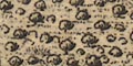
The map is littered with tiny tree symbols, with a shadow to the east. These have no overall impression of being grouped into woods or forests, but some forests are labelled, eg:-
Buckholt Forest
New Forest
Pamber Forest
Little tree symbols, liberally scattered in spaces available on the map, indicate wooded areas. It is possible to see, or imagine, some grouping. Some forests are labelled, eg:-
East Bere Forest
New Forest
Buckholt Forest
Chute For
West Bere For
Wooded areas are indicated by groups of tree and bush symbols with shading for undergrowth. These might be labelled, eg:-
Holt Forest [Buckholt Forest]
New Forest
Forest de Bere [East Bere Forest]
Woodland is indicated by little tree symbols. These are scattered equally with hillocks in all the empty space on the map and across the county borders. They are not informative. Some areas are labelled, which is more helpful, eg:-
Chute Forest
NEW FOREST
Gadshill WoodA few commons etc are labelled, eg:-
Botley Com.
Parley Common
Waltham Chace
Much the same as Kitchin; woodland areas tinted.
Woodland areas are shown by groups of trees, perhaps labelled:-
New Forest
East Bere Forest
Chute ForestOr there might be a label without any tree symbols, eg:-
Harewood ForestOther woods and forests are not noticed.
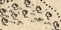
Dots are used to suggest undergrowth.
A couple of commons or heaths are noticed, for example:-
Havant Chace
Aldershot Common
There are some groups of trees drawn to suggest woodland. For example near 'Altham' 51-53m. from London. A wood might be named, eg:-
(plate 20 scroll 2 mile 6)
Austreys WoodWoodland might also be indicated by the destination of a side road, for example plate 20 scroll 2 mile 20):-
into the Forestnear 'Lemington', leading to the New Forest.
A single tree may be named, this example has no tree symbol (plate 20 scroll 2 mile 4):-
Half-way OakA couple of commons are named (plate 20 scroll 1 mile 67-68):-
Morsted Commonand (plate 20 scroll 1 mile 1-2)
Rumsey Commonwhich is now Southampton Common?
At first sight the little tree symbols indicating woodland look to be 'all over', but they are grouped, and perhaps labelled, eg:-
New Forest
Godshill Wood
East Bere ForestSome other vegetation is noticed, eg:-
Pool Heath
Parley Com.
Except for some parks which might have a trees within the palings, only a couple of forests are indicated, by little tree symbols, labelled:-
East Bere Forest / Havant Chace
New Forest
No forests or woods are shown, there are none of significance? A few tree symbols are used to indicate woodland, for example at Kings Somborne, at Broadlands and at Grove Place.
Here and there are small tree symbols indicating woodland. Some of these are labelled, eg:-
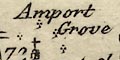
Amport GroveOther labels for woodland are not accompanied by trees, eg:-
Selwood Forest
Not shown.
Woods are indicated by groups of trees, usually with dotted line suggesting ground vegetation. A group of trees might be labelled, eg:-
(page 103/104 scroll 5 mile 5-7)
Austrey WoodTrees are also drawn in parks.
The map has some groupings of very little tree symbols. There is some labelling:-
NEW FOREST
East Bere Forest
Groups of trees and bushes are drawn with doted areas to suggest undergrowth, to indicate woodland, in park grounds or woods or forests. These might be labelled, eg:-
Holt Forest
Watmere Forest
NEW FOREST
Little tree symbols are used to depict areas of woodland and forests, which may be labelled, eg:-
NEW FORREST
East Bere ForestThere are unlabelled, groups, for example near Froyle. Trees are also drawn in parks.
Some labelling indicates commons etc:-
Aldershot Common
Havant Chace
Areas of woodland are shown by groups of tree symbols with dotting to indicate undergrowth. The:-
NEW FORESTis clearly labelled as an area (rather than a forest?) with woods within the area. The other old forests are mostly ignored excepting:-
Watmer Forestie Woolmer. Quite a few woods are labelled, eg:-
Crabwood [W of Winchester]
Dole Wood [S of H'Tarrant]SW of Newtown on the north border is:-
Woodswhich is descriptive, not a name. There are a number of clearly drawn avenues of trees, some in parks as at Hackwood, but others outwith a park, as NE of Titherley.
Some lone trees are named, eg:-
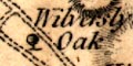
Wilversley Oakto the N of Wilversley Lodge.
Woodland is indicated by areas of various weights of dots. These might be labelled, eg:-
FOREST OF BERE [East Bere Forest]
Horndean Holt
No tree symbols are drawn on the map, but two of the old forests are labelled:-
New Forest
Forest of East Bere
Wood and forests are not shown except by some labelling, eg:-
NEW FOREST
FOREST OF EAST BERE
In Hampshire is labelled:-
NEW FOREST
Wooded areas are shown by dense groups of little tree symbols. Only Woolmer Forest and Alice Holt, East Bere Forest, and the New Forest forests are drawn. Only:-
New Forestis labelled. Woolmer is shown dense with trees which it wasn't. The only other tree symbols are in parks.
Wooded areas are shown by little tree symbols with a pecked ground for underbrush. Some are labelled, eg:-
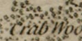
Crab Wood [S of Sparsholt]
Stoke Wood
Sutton Woods [by Droxford]
Pamber Forest
Burnt Wood [by Oakley]It is interesting that Woolmer is shown with lots of rough ground but without trees, whereas Alice Holt has trees. This is right; and is often wrongly done on other maps.
Some trees are noticed, for example:-
Lopton Thornwithout a tree symbol, near Lopcombe Corner, which is not labelled. and two:-
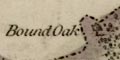
Bound Oakon the boundary with Wiltshire, north edge of the Bramshaw woodland, each with a larger tree symbol. There is a similar tree symbol at a ?settlement:-
Crab Tree Greenwest of Bishops Waltham. And there are other intriguingly suggestive place names, eg:-
Seven Thorns Inn [east of Bramshott]
Bulls Bushes [SSE of Oakley]
Yew Tree Down [east of Dundridge]Other vegetation is suggested by place name and perhaps symbols on the map, eg:-
Priors Dean Common [tussock symbols]
Petersfield Heath
Southington Shrubs
Wide Mead [east of Swathling]
Tuston WarrenTwo of the older forests are noticed particularly by having a dotted border, tinted on our copy of the map. These two are described in a table of data printed on the left.
A few trees are drawn on Horsea Island and Portsdown.
Except for the label:-
NEW FORESTNo wooded areas are noticed.
No woods, forests or other vegetation is shown.
There are no tree symbols, but some aforestation is labelled, eg:-
Bere Forest
New Forest
Some forests are shown by areas of trees plus dotted ground, tinted green, labelled:-
The Holt Forest [ie Alice Holt]
Woolmer Forest
Forest of East Bere
NEW FORESTand there are a few woods:-
Mays Cops [E of East Bere F]
Litchfield Woodperhaps just implied:-
Dole Wood Lodge [H'bourne Tarrant]Some common lands are labelled, eg:-
Week Comm.
Curdridge Common
Yately Heath
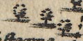
Woodland is indicated by large and small tree and bush symbols, in enclosed and unenclosed groups. Many groups of trees are accompanied by dotting for rough or uncultivated ground. The density of ground cover and bushes and trees is varied to give an impression of real landscape. Many woods are labelled, eg:-
FOREST of BERE
Out Hurst Wood
In Hurst Wood
Holt Wood
Bells Coppiceall in the East Bere Forest area. Nearly all woods are shown with deciduous tree symbols. There are some fir trees noticed, eg:-
Fir Treesby an indeterminate symbol east of Catherington.
In a park the tree symbols might be drawn in avenues.
There is an unnamed plantation of fir trees, in rows, on The Barnet south of Colemore.
A few individual trees are labelled, not always attached to a particular tree symbol, eg:-
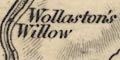
Wollaston's Willow [E of Bossington]
Marlpit Oak [S of Brockenhurst]
Bound Oak [W of Rowlands Castle]
Bound Tree [S of Dibden]
Yew Tree [E of Dibden]which last may just be descriptive, not a name, but it does have its own distinctive tree symbol, a fir.
A variety of land areas are labelled indicating their nature, eg:-
Blendworth Comn.
Creech Plain
West Heath [W of Pamber]
Hartford Bridge Flats
Wallop Fields
Peat Moor
As well as a few trees in parks there are groups of trees symbols for some of the old forests. Some are labelled, eg:-
Holt Forest
Watmere Forest [Woolmer Forset]
East Bere Forest
New Forestbut no more.
Woodland is not indicated.
Woodland is indicated by groups of small tree symbols, with dotting for undergrowth. Some groups are labelled, eg:-
Holt Forest [Alice Holt]
Watm[e]re Forest [Woolmer Forest, with lots of trees]
NEW FOREST
Woodland is indicated by groups of tree symbols, with dotting to suggest undergrowth or rough ground. Woods or forests might be labelled, eg:-
Faccombe Wood
FOREST of BERE [East Bere Forest]
NEW FOREST
Chawton Wood
Wooded areas are not noticed, tho:-
NEW FORESTis labelled as an area in Hampshire.
Woods are not shown.
Woods are still not drawn but
Alice Holtis labelled.
Woodland is indicated by groups of deciduous tree symbols, in several sizes, with dotting to suggest rough ground or undergrowth. The groups might be enclosed in an outline or unfenced, and might be labelled, eg:-
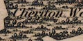
Cheriton Wood
Clatford Oak Coppice
Arnolds Copse
Sandys Inclosure
Pheasantry
NEW FOREST
WOOLMER FORESTWhich of these labels are names and which are just descriptive is an interesting question.
As well as woods some individual trees might be noticed, eg:-
Three Yew Trees [NE of Martyr Worthy]with three tree symbols.
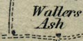
Wallers Ash
Bound Oakie boundary oak, which are not by an obvious tree symbol, and:-
Tangley Clumpswhich labels several groups of trees.
Other vegetation might be noticed, heath and common are dotted areas, and might be labelled, eg:-
Wellesleys Warren
Headly Common
Yateley Heath
There are a number of tussocky areas drawn on the map, with small bushes and trees, showing commons, woods, forests, etc. Some are labelled, eg:-
Forest of Bere
Dole Wood
Alice Holt WoodTracks across such areas might be indicated as unfenced roads.
There are groups of small tree symbols marking woodland, some of which are labelled, eg:-
Holt Forest
Woolmer ForestThe impression is that the map maker is trying to show woods that are now; not harking back to the ancient royal forests. Trees are drawn within parks.
A few areas of woodland are shown by a few tree symbols and dotting to suggest rough ground. The only woodland area marked in Hampshire is the:-
NEW FOREST
Woodland is shown by groups of tree and bush symbols, with undergrowth. Some areas are labelled, eg:-
Daily Wood [Doyle's??]
Alice Holt Wd.
Otterwood
Beer Forest [East Bere Forest]
No woodland is indicated. And, unusually, the New Forest is not even labelled.
Groups of tree symbols mark woodland; there are more than just the 'old' forests. They might be labelled, eg:-
Alice Holt W.
NEW FOREST
Otterwood [SE of Beaulieu]Woolmer Forest is not marked by trees, which is right, nor labelled.
Woodland is not generally noticed on the map. But the:-
NEW FORESTis labelled, and much of its area has dotting to suggest rough country.
Woodland is not indicated, except for the area label:-
The New Forest
No woodland is indicated by symbols, but:-
NEW FORESTis labelled as an area.
The
NEW FORESTis clearly labelled, and decorated with grass and tussock symbols, bushes and trees. Elsewhere little tree symbols are used very sparingly, in enclosures, but notice:-
Freefolk WoodNone of the other great forests are noticed.
Little tree symbols in clumps, indicate some woodland, with dotter lines for undergrowth. At least two of the old forests are labelled:-
NEW FOREST
Forest of Berethe second being East Bere Forest.
A tree might be labelled, eg:-

Royal Oaksouth west of Fritham.
Wooded areas might be indicated by little tree symbols with pecked undergrowth. There are example in the:-
NEW FORESTarea, west of Minstead. And at:-
Alice Holt Wd.Labelled, without trees is:-
Bere Forestwhich is East Bere Forest north of Havant.
Woods and forests are shown by small bushes and trees and horizontal dotted lines to indicate undergrowth. This marking is done in many parks. Some forests are labelled, eg:-
Forest of Bere
Alice Holt Forestwhich have trees, and, for example:-
Woolmer Forestwhich, correctly, doesn't have trees.
Some woodland is shown as a small enclosure which could be confused with a park, eg:-
Pamber Forest
A few patches of woodland are noticed for their value as sea marks. On Portsdown there is:-
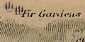
Fir Gardens
Six Clumpsthe last being five groups of three fir tree symbols.
No woods are drawn.
There are no tree symbols for wooded areas, but some woods or forests are noticed by labelling, eg:-
Holt Forest
Forest of East BereThe New Forest is not labelled.
Woodland is indicated by tree, bush, and undergrowth symbols, and perhaps labelling, eg:-
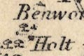
Benworth Holt
Faccombe Wood
NEW FOREST
FOREST OF BERE [East Bere Forest]Or might be labelled, without any trees, eg:-
Holt Forest
Woolmer ForestIt makes a change to see Woolmer, which has few trees, drawn without woods; but Alice Holt should have some. The old forests are not particularly noticed.
Some areas may be labelled as commons, etc, eg:-
Horsdon Comn. [S of Odiham]
Two of the old forests are shown as areas with very small tree and bush symbols, with dotted undergrowth. The two are labelled:-
Forest of Bere
New ForestIt is East Bere Forest that is shown.
Woodland is not indicated, but:-
THE NEW FORESTis labelled as an important area.
Woods and forests are marked by group of tree symbols, some labelled, eg:-
Faccombe Wood
Dole Wood
NEW FOREST
FOREST of BERE [East Bere Forest]
Alice Holt Forest
WOOLMER FORESTwhich last has no trees, a reminder that 'forest' is a hunting area rather then a lot of trees.
There is a:-
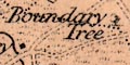
Boundary Treemarked as a single tree south of Dibden in the New Forest area. There are the:-
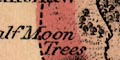
Half Moon Treesmarked as a small group east of Paulton Park.
A number of downs, commons, heaths, etc are labelled, eg:-
Beaulieu Heath
Arnwood Common
Easton Down [E of Winchester]
Waltham Chace
Longwood WarrenSome of the common areas are marked by pecking plus small bush symbols. This is also used for undergrowth in some woodland areas of East Bere Forest and is all that is marked for Woolmer Forest.
Woodland is indicated by groups of small tree symbols with dotting to suggest rough ground or undergrowth. Some woods, or forests, are labelled, eg:-
Highden Wood
Farley Wood
NEW FOREST
BERE FOREST [East Bere Forest]Most of the old great forests are not noticed.
A lot of woodland is indicated by little tree symbols, with bushes and dotted lines for undergrowth. Some of these have an outline boundary. A number are labelled, eg:-
Doles Wood
Basely Copse
Highden Woodas well as the larger:-
FOREST OF BERE [East Bere Forest]
Woolmer Forest [correctly lacking trees]
Alice Holt ForestAn individual tree might be labelled, eg:-
Marplit Oakby a road W of Boldre, without a tree symbol.
There are some groups of little tree symbols to mark woods, which might be labelled, eg:-
Crab Wood
Micheldever Wood
NEW FOREST
Hare Wood ForestThere might be a label without symbols, eg:-
Knight Wood [near Chandlers Ford]
Some woodland areas are shown by tree, bush, and undergrowth symbols, which might be labelled, eg:-
FOREST OF BERE [East Bere Forest]
NEW FOREST
Harewood ForestThe last in three areas bounded by dotted lines. Also notice:-
Woolmer Forestdrawn ,correctly, without trees; and just to its north:-
Alicewhich should be 'Alice Holt', and should have trees but hasn't.
Woods are mostly not shown. But:-
NEW FORESTis labelled.
Woodland is indicated by groups of tree symbols with dotting to indicate rough ground. The wood or forests might be labelled, eg:-
Alice Holt Wood
WOOLMER FORESTlabelled, with no trees, which is about right, and:-
Laverstock Wood
HAREWOOD FORESTOther rough ground might be indicated by dotting, and labelled, eg:-
Yateley Heath
Eversley Common
Peat Moorall in the area of the:-
Hartford Bridge Flatswhich is labelled alongside the London road.
Some woodland is indicated by tree symbols.
Wooded land is indicated by little tree symbols. Some of the ancient forests are labelled, eg:-
Woolmer Forestwhich is drawn with trees, though it is not certain it had many at that time? Also:-
Bere Forest [East Bere Forest]
New ForestWoods are not much [not at all] shown elsewhere.
Woodland is indicated by groups of little tree and bush symbols, with dotting to suggest undergrowth and rough ground. Wooded areas might be labelled, eg:-
NEW FOREST
Forest of Bere [East Bere Forest]And some woods might be labelled, but have no tree symbols, eg:-
Queens Wood [by Tytherley]
Woolmer ForestThe latter never was much wooded. Some woods are enclosed, as at Farley.
woodland is indicated by groups of tree and bush symbols, perhaps labelled, eg;
NEW FOREST
Forest of Bere [East Bere Forest]
High Wood
Faccombe Wood
Wherwell WoodNot all forests are densely covered with trees, and undergrowth is suggested by dotting.
Notice the:-
Swanwick Elma placename or a tree name?
No woods are shown.
A couple of woodland areas are shown by groups of little tree and bush symbols, labelled:-
Forest of Bere [East Bere Forest]
New Forest
Highden Wood [N of Clanfield]The last is outlined.
A couple of heathland areas in the New Forest are labelled:-
Beaulieu Heath
Ashley Heath
Wooded areas are shown by tree symbols over a green tint.
Woodland is mostly ignored. In Hampshire there are small tree or bush symbols and dotting for rough ground, labelled:-
New Forest
No rivers, relief or woodland is shown.
Only very few non railway details are shown, eg:-
SALISBURY PLAINlabelled and drawn by a shaded red area. A bold dotted circle is labelled:-
STONEHENGEIn Hampshire the:-
NEW FORESTis labelled, but there are no tree symbols.
Woodland is indicated by tree symbols (which look more like little bushes or upsidedown trees). Most woods are enclosed by a line; some are labelled, eg:-
HAVANT THICKET
RAKE HANGER
DURFORD WOODRough land is indicated by rows of dots for tussocks, and perhaps labelled, eg:-
HEATH DOWN [by Buriton]
Woodland is indicated by small tree symbols, with bushes and dotting for undergrowth. The symbols are printed in black over a green ground. Deciduous and coniferous trees are distinguished; and orchards have trees in rows. Areas of woodland are outlined with a solid or dotted line, fenced or unfenced, and might be labelled, eg:-
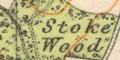
Stoke WoodNNW of Hambledon. On sheet 132 the:-
FOREST OF BEREmeaning East Bere Forest, is labelled across an area north of Havant, with some areas of woods.
Woods might be labelled, eg:-
DODSLEY WOOD [on left before Winchester, page 15]
GREAT DEAN WOOD [on right, past Oakley, page 14]on the left a few miles before Winchester, page 15.
woods, forests |
|||||||||||||||||||||||||||||||||
| tree symbols |  |
|
|
|
|
|
|
|
|
|
|
|
|
|
|
|
|
|
|
|
|
|
|
|
|
|
|
|
|
|
|
|
|
Colebourn, Phil: 1983: Hampshire Countryside Heritage, Ancient Woodland: Hampshire CC (Winchester, Hampshire):: ISBN 1 85975 046 X
Read, Chris: 1999: Ancient New Forest Trees: ProcHFC: vol.54: pp.63-74
Shore, T W: 11880=1889 (?): Ancient Hampshire Forests and the Geological Conditions for their Growth: ProcHFC: vol.1-2: pp.40-60
Sumner, Heywood: 1931: J Norden's Survey of Medieval Coppices in the New Forest AD1609: ProcHFC: vol.10: pp.95-117
