|
FA2002.502:-
|
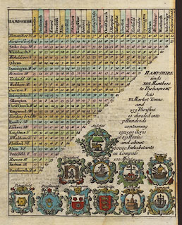
table of distances, for Hampshire, from Magna Britannia et Hibernia Antiqua
et Nova, published complete by Thomas Cox, London, about 1730, this part first
published about 1718
|
|
Descriptive text for Herefordshire begins on the back; it would be continued for
a couple of dozen pages.
|
|
inscription:- |
printed -on- title
HAMPSHIRE
|
|
dimension:- |
wxh, sheet = 17x22.5cm |
|
wxh, table = 146x184mm |
 |
|

|
Map Group -- Cox 1738 -- with Research Notes
|
|
|
|
town names:-
|
|
Hampshire
|
Hampshire
|
|
map name
|
modern name
|
|
Alton
|
Alton
|
|
Andover
|
Andover
|
|
Basingstoke
|
Basingstoke
|
|
B. Waltham
|
Bishops Waltham
|
|
Christ Church
|
Christchurch
|
|
Fareham
|
Fareham
|
|
Fording brid
|
Fordingbridge
|
|
Havant
|
Havant
|
|
Kingscleare
|
Kingsclere
|
|
Lymington
|
Lymington
|
|
Alresford
|
Alresford
|
|
Odyam
|
Odiham
|
|
Petersfield
|
Petersfield
|
|
Portesmouth
|
Portsmouth
|
|
Ringwood
|
Ringwood
|
|
Rumsey
|
Romsey
|
|
S Hampton
|
Southampton
|
|
Stoke bridge
|
Stockbridge
|
|
Whitchurch
|
Whitchurch
|
|
Winchester
|
Winchester
|
|
|
|

| top of page |
| MN: 10.10.2002 |