| Antiquities
Blaeu's Hampshire 1645
|
|

| click for feature map
|
|
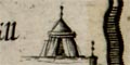
There two quite clear tents drawn on John Blaeu's map, which signify what?
|

|
tent (Southampton parish)
|
|
|
tent (Winchester parish)
|
|
|
Some british tribal areas are labelled on the map, ie:-
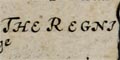
THE REGNI
in the south west of the county (above Southampton), and
THE SEGONTIANS
in the north (by Silchester).
|
| hillforts
|
Very few hills are named on the map. Danebury and Butser hill
are picked out; perhaps because they have hillforts, perhaps
just because they are named on a map being copied.
|
|
|
Beacon Hill Camp (Burghclere parish; SU458572)
|
|
|
Butter hill
(Eastmeane Hundred)
= Butser Hill
(Langrish parish; SU7120)
|
|
|
Dunbury hill
(Andover Hundred)
= Danebury Hill
(Nether Wallop parish; SU3236)
|


