Beacons
Blaeu's Hampshire 1645Four beacons are indicated on Blaeu's map, these are marked on the feature map of hills. In the list below the grid references are approximate.
At Bushy the settlement symbol on the hill, copied from John Speed, is perhaps the beacon here. The settlement names are all otherwise accounted for by symbols.
At Popham the beacon is shown by three posts on the hill, which suggests, as on other maps, that this beacon was a triple beacon.
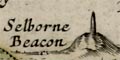
Selborne Beacon is shown by a large post or tower. (A similar mark is used for Merden Beacon in Sussex.)
Toothill Beacon has no symbol; but is clearly labelled.
'modern' name (parish; ngr) and old name (hundred) if given

References
|
White, H T: 1931: Beacon System in Hampshire, The: ProcHFC: 10: pp252-278 White, H T: 1947: Beacon System in Hampshire, The: ProcHFC: 16: pp19-22 |

| Blaeu's Hampshire 1645, contents |

| feature list |
|
| General index |

| Old Hampshire Mapped |
Map HMCMS:FA1998.149