Trees, Woods, Forests
Blaeu's Hampshire 1645
woods
'modern' name (parish; ngr) and old name (hundred) if given

|
| Trees, Woods, ForestsBlaeu's Hampshire 1645 |
|
| click for feature map |
| Trees |
Woods and forests, on Blaeu's map of Hampshire, are shown by
little trees. These are grouped, drawn with bushes and
shaded ground areas, to make small landscapes. There are also
trees in parks. The old forests on Blaeu's map are listed below. |
|
forests woods |
BEWARE: to get back to this list after clicking on an item,
use the back button. 'modern' name (parish; ngr) and old name (hundred) if given |
|
|
Buckholt Forest = Buckholt Forrest (Thornegate Hundred) |
|
|
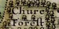
Chute Forest = Chure Forrest (Andover Without Hundred) |
|
|
East Bere Forest? = Beare Forest (Portesdowne Hundred) |
|
|
New Forest = Newe Forrest (Rinwood Hundred) |
|
|
West Bere Forest = West Forrest (Budlesgate Hundred) |
References
|
Coleburn, Phil; Court, Nicky; Howe, Johnathon: 1995 (2nd edn):
Ancient Woodland: Hampshire County Council (Planning Dept)::
ISBN 01 85975 046 X |

| Blaeu's Hampshire 1645, contents | |
|
| feature list | |
|
| General index | |

| Old Hampshire Mapped | |