Beacons
Harrison's Hampshire 1788'modern' name (parish; ngr) = old name (hundred) if given

|
| BeaconsHarrison's Hampshire 1788 |
| Beacon hills |
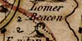
Beacons are shown on Harrison's map of Hampshire as a tower
on a hill with flames coming out of the top. Harrison shows
only two beacons; this map is drawn two centuries after the
Armada, the beacon system is no longer important. This map,
1788, is just a few years too early to show the new
telegraphs, shutters in 1796 then semaphores in 1812, being
organised by the Admiralty for signalling between London
and Portsmouth. Those telegraphs relied on line-of-sight
as did the beacons. The beacons shown are:- |
| beacons |
BEWARE: to get back to this list after clicking on an item,
use the back button. 'modern' name (parish; ngr) = old name (hundred) if given |
|
|
Lomer Beacon? (Exton parish; SU603225) = Lomer Beacon (Fawley Hundred) |
|
|
Selthorne Beacon? (Brockenhurst parish; SZ273999) = Selbone Beacon (New Forest Hundred) |
References
|
White, H T: 1931: Beacon System in Hampshire, The: ProcHFC:
10: pp252-278 White, H T: 1947: Beacon System in Hampshire, The: ProcHFC: 16: pp19-22 |

| Harrison's Hampshire 1788, contents |

| feature list |
|
| General index |

| Old Hampshire Mapped |