Trees, Woods, Forests
Harrison's Hampshire 1788
We have not tried to match all the groups of trees to present day woods.
woods
trees
'modern' name (parish; ngr) = old name (hundred) if given

|
| Trees, Woods, ForestsHarrison's Hampshire 1788 |
|
| click for feature map |
| Trees |
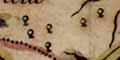
Trees, on Harrison's map of Hampshire, are shown by a circle
with a trunk. Many of the trees appear to be no more
than decoration - but as this symbol probably has a low
priority the distribution cannot be taken to be very reliable
or significant. The trees sometimes seem to be grouped
into woods or forests; in many cases these groupings can
be identified with the royal forests of a previous age.
Forests on Harrison's map are listed below. We have not tried to match all the groups of trees to present day woods. |
|
forests woods trees |
BEWARE: to get back to this list after clicking on an item,
use the back button. 'modern' name (parish; ngr) = old name (hundred) if given |
|
|
Bolderwood Lodge Inclosure (Minstead parish; SU2_0_) = Bolderwood Lodge (New Forest Hundred) |
|
|
Buckholt Forest |
|
|
Burley Lodge Inclosure (Burley parish; SU2_0_) = Burley L. (New Forest Hundred) |
|
|
Chute Forest = Chute Forest (Pastrow Hundred) |
|
|
East Bere Forest? = Forest of East Bere (Portsdown Hundred) |
|
|
New Forest = New Forest (New Forest Hundred) |
|
|
Pamber Forest (Pamber parish; SU6161) |
|
|
Parkhill Inclosure (Denny Lodge parish; SU3105) |
|
|
Rhinefield Sandy's Inclosure (Brockenhurst parish; SU2504) |
References
|
Coleburn, Phil; Court, Nicky; Howe, Johnathon: 1995 (2nd edn):
Ancient Woodland: Hampshire County Council (Planning Dept)::
ISBN 01 85975 046 X |

| Harrison's Hampshire 1788, contents |
|
| feature list |
|
| General index |

| Old Hampshire Mapped |