lat and long scales
Kitchin's Hampshire 1751longitude
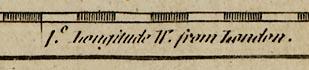
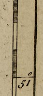
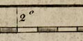
The borders of the map have latitude and longitude scales, the implied graticule at an angle to the borders of the map. The latitude scales on left and right are chequered in 1 minute intervals, labelled at 15 minute intervals; the longitude scales at top and bottom are chequered at 1 minute intervals, labelled at 30 minute intervals. The bottom scale is labelled:
Longitude W. from London.
Crude calculations from the positions of the scale marks show that the ratio of latitude to longitude scales is about 1.55. This is equal within errors to the value, 1.585, correct for the latitude of Hampshire.
The angle of the 1 degree W meridian is about 2.6 degrees to vertical. The 51 degree N parallel is horizontal. The graticule is drawn of parallelograms, sheared rectangles.
Summary
- Sheared rectangular latitude and longitude scales.
- Parallels aligned horizontally to the page; meridians 2.6 degrees E of W.
- Ratio of lat/long correct ratio for Hampshire.
from the best SURVEYS & INTELLIGENCESthe map's title cartouche says it is:
Regulated by ASTRONL. OBSERVATIONS.
The positions of the more important towns in Hampshire were read off Kitchin's large 1751 map as well as possible, to compare with the values given by the OS Gazetteer of Great Britain. The question of exactly what part of each town was being used is ignored; the mapping errors that are found are so gross that this is an unimportant factor.
Average latitude error = 01.5 minutes
rms deviation = 0.9 mins
Average longitude error = 06.7 minutes
rms deviation = 4.6 mins
The offset in longitude just indicates that the prime meridian used was not the correct meridian at Greenwich. The prime meridian is about 6.7 + 4.6 minutes west of Greenwich; this might be a meridian through St Paul's, London?
The raw figures don't mean much. It is more instructive to understand the rms deviation in miles on the ground or cm on the map (calculated for 51 degrees N):
rms deviation in latitude = 1.0 miles, 1.2 cm on map
rms deviation longitude = 3.3 miles, 3.9 cm on map
These are not just errors of pencil line thickness! The map hardly merits the description of being 'Regulated' by astronomical observations.


