Roads
Kitchin's Hampshire 1751
but also see:
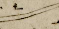
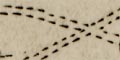
The Direct and principal Cross Roads are Marked where Open or Heathy thus
Across the middle of some road segments, within a circle, are road distances.
Distances between Market Towns thereon, are laid down in Measured Miles and Furlongs.
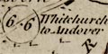
There is often an indication of where the road is going, eg:
6.6 Whitchurch to Andover
At the bottom of the table of symbols is a handy reminder:
NB A Furlong is the eighth part of a Mile.
Roads out of the county might be labelled with their destination:
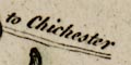
to Chichester
All the Ogilby routes across the county are included, with, by this later date, extra main roads such as: Winchester to Fareham, Cosham, Havant, Chichester; Petersfield to Havant; Winchester to Stockbridge etc; Romsey to Fordingbridge and west; Lymington to Southampton, via Lyndhurst and via Bealieu and Hythe, but both via Redbridge.
Three distances are tabulated for each pair of towns:-
- read from John Ogilby's plate
- written distance on Thomas Kitchin's map
- calculated crow flight distance from Kitchin's map
| town - town | Ogilby plate 25/26 |
Kitchin written |
Kitchin crow flight |
| Staines - Basingstoke | 29'1 | 29'2 | |
| Basingstoke - Whitchurch | 11'2 | 11'2 | 11'6 |
| Whitchurch - Andover | 6'6 | 6'6 | 8'1 |
| Andover - Salisbury | 17'4 | 17'4 | |
| plate 30 | |||
| Godalming - Petersfield | 20'6 | 20'6 | |
| Petersfield - Portsmouth | 18'0 | 17'6 | 17'2 |
| plate 32 | |||
| Andover - Amesbury | 14'3 | 13'6 | |
| plate 39 | |||
| Midhurst - Petersfield | 10'6 | 11'0 | |
| Petersfield - Winchester | 18'2 | 18'2 | 17'1 |
| plate 51 | |||
| Staines - Farnham | 21'6 | 21'4 | |
| Farnham - Alton | 9'3 | 9'4 | |
| Alton - Alresford | 9'6 | 9'6 | 9'2 |
| Alresford - Southampton | 18'3 | 18'6 | 19'4 |
| Southampton - Romsey | 8'3 | 8'4 | 7'1 |
| Romsey - Salisbury | 17'2 | 17'0 | |
| plate 53 | |||
| Basingstoke - Stockbridge | 21'2 | 21'2 | 23'1 |
| Stockbridge - Downton | 15'2 | 15'0 | |
| Downton - Cranborne | 11'4 | 11'6 | |
| plate 81 | |||
| Newbury - Kingsclere | 7'1 | 7'[ ] | |
| Kingsclere - Basingstoke | 9'2 | 9'2 | 10'7 |
| Basingstoke - Alton | 10'5 | 10'4 | 8'5 |
| Petersfield - Chichester | 14'7 | 14'7 | |
| plate 83 | |||
| Hungerford - Salisbury | 28'6 | 27'0 | |
| plate 85 | |||
| Salisbury - Marlborough | 27'2 | 27'4 | |
| plate 97 | |||
| Alresford - Winchester | 7'4 | 21'2 | 11'2 |
| Winchester - Romsey | 11'3 | 11'2 | 8'1 |
| Romsey - Ringwood | 17'7 | 17'6 | 17'4 |
| Ringwood - Poole | 14'0 | 14'0 | |
| Poole - Christchurch | 10'4 | 10'2 | |
| Christchurch - Lymington | 11'2 | 11'6 | 9'7 |
| Southampton - Winchester | 12'2 | 12'0 | 10'0 |
| (no plate) | |||
| Winchester - Bishops Waltham | 9'2 | 7'3 | |
| Bishops Waltham - Fareham | 9'[0] | 7'6 | |
| Lymington - Southampton | 17'6 | 14'1 | |
| Basingstoke - Winchester | 19'4 | 20'6 | |
| Winchester - Stockbridge | 7'0 | 6'5 |
Many of Thomas Kitchin's distances agree with the distances from John Ogilby's plates, allowing for errors in reading the mile marks on the latter.
Comparing Thomas Kitchin's written distances with the crow flight distances measured off his own map there are a few surprises. Some of his written distances are less than the crow flight distance! And there is one obvious error, see Alresford - Winchester.


