
scale line
Kitchin's Hampshire 1751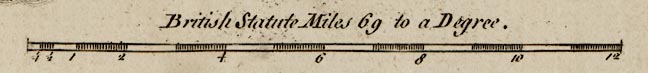
There is a scale line of 12 miles, chequered at 1/4 then 1/2 then 1 mile intervals. Labelled:
British Statute Miles 69 to a Degree.The 12 miles = 100.4mm gives a scale 1 to 192352 assuming a modern mile, scale about:
1 to 190000Another estimate of scale can be got by comparing the position of a number of towns with their 'known' positions, using modern ngr positions. The measured average scale is 2.95 statute miles to 1 inch, ie 1 to 186731. The range of scales is from 1.95 to 5.18 statute miles to 1 inch. From its scale line the map scale is 3.04 map miles to 1 inch, ie nominally 1 to 192324 ?
3 miles to 1 inch
Kitchin's map miles = 0.97 statute miles.
map miles = statute miles within errors


