relief, hills
Morden's Hampshire 1695
- important or isolated hills
- steep scarp
- uneven ground, hilliness
- high ground, ie altitude
- watersheds
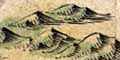
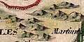
The drawing of hills has to compete with the placing other information on the limited map space. We do not know what priority was given to hills; it would be interesting to know in what order symbols were engraved on the printing plate. The hills are beautifully engraved, fairly uniform in size; their grouping is arranged nicely.
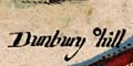
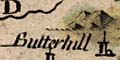
An important or isolated hill might be the site of a fort, beacon, castle, or town. The location might be named, for example Dunbury hill or Butterhill where the name applies to the site as much as anything else.
A steep scarp might be shown as a line of hills, for example at Portsdown. Some scarps are missed.
The line of hills drawn north of Winchester is not a scarp, but is high rolling downland, and is a watershed.
The other categories of hills seem to have a lower priority, and it is less clear what was intended. There seem to be more hillocks drawn where ground is high, say above 100m. In Hampshire high ground tends to be hilly ground. Low lying hilly ground seems to lack hillock symbols; but the space on the map is often taken up by trees in woods and forests.


