miscellany
Morden's Hampshire 1695Mr Williams-Freeman -
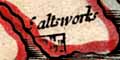
... Salterns. They exist everywhere along the seaside and up our estauries, generally as a flat sea marsh known only by their name. Three 'salt pans' are recorded and valued in Domesday Book at Eling, Dibden and Hordle, but it was in the Middle Ages when all the great houses killed off their cattle in the autumn and salted them down for winter use, that they flourished most, and the traffic inland is marked by the numerous Saltways and Salters' Lanes that are found in old maps and still survive.Camden notes saltworks along the Hampshire coast.
Mr. Heywood Sumner has mapped and described two of them in his Earthworks of the New Forest - the great one near Lymington which is said to have paid Ł50,000 in duty to the Echequer in one year in the 18th century, and the smaller one west of Needsore Point at the mouth of the Beaulieu River. Probably it served the Abbey. But the most ancient in our county was only discovered about two years ago near Warsash by the finding of a large quantity of broken red pottery of peculiar and unknown character to any of us who saw it, but now recognised as identical with that found in the mysterious Red Hills on the Essex coast, and these are now accepted as being Roman Salterns.
The current OS map shows ancient and new salterns near Lymington, at SZ3292 and SZ3293 respectively.
Hampshire CC Museums Service has several of this map, each treated in a different way by its colourist.
Notes about colouring
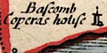
In what is now Dorset, east of Christchurch, Morden marks Bascomb Coperas house ie Boscombe Copperas House?
Mining in the Canford Heath area for ores to make copperas, green vitriol, and potash alum, was an important venture in Elizabethan times.
Notes about copperas


