| Rivers
Morden's Hampshire 1695
|
|

| click for feature map
|
| Rivers
|
Morden's map shows a number of rivers; some of them are named.
All of Hampshire's major rivers are shown, but there are some
little streams shown which might have been left out, and some
not shown which might have been included.
The style of drawing of rivers is schematic. The width of the
engraved lines decreases as you go up, but not to match the
rivers true size [as judged today], and although braiding is
indicated it is not an exact match to the rivers [today's]
courses. The rivers that are shown can mostly be indentified,
but with a degree of guesswork because accuracy is not all it
could be on the map!
|
|
| Comparison with Norden's rivers
|
|
| rivers |
BEWARE: to get back to this list after clicking on an item,
use the back button.
'modern' name (parish; ngr) = old name (hundred) if given |
 |
Alre, River (Itchen Stoke and Ovington parish; SU5732)
= Alre R (Fawley Hundred)
|
|
|
Anton, River (Wherwell parish; SU3839)
|
|
|
Avon Water (Milford-on-Sea parish; SZ3091)
|
|
|
Avon, River (Christchurch parish; SZ1692)
= Avon R (Ringwood Hundred)
|
|
|
Bagwell Stream? (Hook parish; SU740543?)
|
|
|
Bartley Water (Totton and Eling parish; SU3612)
|
|
|
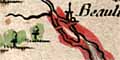
Beaulieu River (Beaulieu parish; SZ4297)
|
|
|
Black Brook? (Fareham parish; SU579058)
|
|
|
Blackwater River (Bramshill parish; SU7463)
|
|
|
Blackwater, River (Totton and Eling parish; SU3615)
|
|
|
Bourne Rivulet (Hurstbourne Priors parish; SU4445)
|
|
|
Bow Brook (Bramley parish; SU6758)
|
|
|
Candover Stream (Itchen Stoke and Ovington parish; SU5631)
|
|
|
Christchurch Harbour (Christchurch parish; SZ1791)
|
|
|
Clere Water? (Ashford Hill with Headley parish; SU5363)
|
|
|
Cove Brook (Hawley parish; SU861589)
|
|
|
Criddell Stream (Petersfield parish; SU7723)
|
|
|
Danes Stream (Milford-on-Sea parish; SZ2991)
|
|
|
Dever, River (Barton Stacey parish; SU4041)
|
|
|
Dibden Stream? (Hythe and Dibden parish; SU431074)
|
|
|
Ems, River (Havant parish; SU7505)
|
|
|
Enborne, River (Ashford Hill with Headley parish; SU5563)
|
|
|
Hamble Haven (Hamble parish)
= Hamble haven (Waltham Hundred)
|
|
|
Hamble, River (Hamble parish; SU4804)
|
|
|
Hart, River (Bramshill parish; SU7460)
|
|
|
Hermitage Stream (Havant parish; SU7005)
|
|
|
Holybourne Stream (Alton parish; SU7340)
|
|
|
Itchen, River (Southampton parish; SU4209)
= Itchin R (Waltham Hundred)
|
|
|
Kingsclere Stream? (Ashford Hill with Headley parish; SU5363)
|
|
|
Langstone Harbour (Havant parish; SU6802)
= Langston Haven (Portesdown Hundred)
|
|
|
Lin Brook (Ringwood parish; SU147058)
|
|
|
Linford Brook (Ellingham, Harbridge and Ibsley parish;
SU19260821)
|
|
|
Loddon, River (Stratfield Saye parish; SU7063)
|
|
|
Lyde River (Sherfield on Loddon parish; SU6956)
|
|
|
Lymington River (Lymington and Pennington parish; SZ3493)
|
|
|
Meon, River (Fareham parish; SU5302)
|
|
|
Moors River (Hurn parish; SZ1395)
|
|
|
Oakhanger Stream (Selborne parish; SU7836)
|
|
|
Ober Water (Brockenhurst parish; SU2904)
|
|
|
Otterbourne Stream? (Otterbourne parish; SU4622)
|
|
|
Park Stream (Michelmersh parish; SU3432)
|
|
|
Pillhill Brook (Upper Clatford parish; SU3544)
|
|
|
Ports Creek
|
|
|
Portsmouth Harbour (Portsmouth parish)
|
|
|
Rother, River (Steep parish; SU7723)
|
|
|
Ryebridge Stream (Froyle parish; SU7642)
|
|
|
Slea, River (Headley parish; SU819387)
|
|
|
Somborne Stream?? (Kings Somborne parish; SU3430)
|
|
|
Southampton Water
|
|
|
Southampton Water
= Trisanton
|
|
|
Stour, River (Christchurch parish; SZ1692)
= Stour R (Christchurch Hundred)
|
|
|
Test, River (Southampton parish; SU4209)
= Trisanton (Redbridg Hundred)
|
|
|
Titchfield Haven (Fareham parish; SU5303)
= Tichfield bay (Waltham Hundred)
|
|
|
Turmer Brook (Ellingham, Harbridge and Ibsley parish; SU139087)
|
|
|
Wallington River (Fareham parish; SU6003)
|
|
|
Wallop Brook (Houghton parish; SU338307)
|
|
|
Wey Brook (Sherborne St John parish; SU642584)
|
|
|
Wey, River (Binsted parish; SU8144)
|
|
|
Whitewater, River (Bramshill parish; SU7463)
|


