roads

Morden's Hampshire 1695

click for feature map
Roads Morden's 'Pocket Book of all the Counties of England and Wales' 1680, using the maps published on a set of playing cards 1676, has a Hampshire map with roads, but is too small to be useful, the roads are too indistinct. Morden's 1695 map is one of the earlier maps of Hampshire to show roads. A few principle routes are shown; all correspond, roughly, to one of the routes in Ogilby's Britannia, published 1675; not all of Ogilby's choices of routes are marked.

The road routes do not correspond exactly to Ogilby's routes. For example: Yately is north of the Ogilby road in his plate 25, ie on the right travelling west; on Morden's map Yateley is on the east of the road, ie on the left travelling west. It is quite difficult to know whether Morden's road goes through or near places: it misses too many places! Cochrane's book makes a suggestion about this (which we don't believe and won't repeat!).
Route
diagrams
The following diagrams - which are not to any regular scale - indicate which places on Morden's map are on or close to the Morden road line; listed under Ogilby plate numbers for convenience. The layout of the diagrams follows the layout of Ogilby's road maps, ie you travel up the page, generally going away from London: this is rather disorientating when up is southwards, normally down on a modern map! Places are shown to right and left of the diagram as they would appear to a traveller going up the page, away from London.
Route 25 Yately to Andover
Route 26 Andover to Wiltshire border, Nether Wallop
Route 30 Surrey border, Bramshott, to Portsea
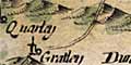
Route 32 Andover to Wiltshire border, Grately
Route 39 Petersfield to Winchester
Route 51 Surrey border, Bentley, to Southampton

Route 25
From the Surrey border near Yately to Andover. It enters the county too far NW. From Hertfordbridge this is close to Ogilby's route, plate 25, part of the road from London to the Lands End; it misses Hurstbourne Priors.

'up' on the page is WSW.

map square SU34
continues, see
roads 26x, 32
Andover
Andover (SU3645)


map square SU44
Swampto~ Swampton (SU4150)
Husborn
Hurstbourne Priors (SU4346)
Bourne Rivulet


map square SU45
Whitchurch
Whitchurch (SU4647)
River Test
Charlecote
(SU4849)
Frifalke Freefolk (SU4948)


map square SU55
Southamton Southington (SU5049)
Overton Overton (SU5149)
Polhamto~ Polhampton Farm (SU5250)
River Test
Ash Ashe (SU5350)
Deane
Deane (SU5450)
Churchockly
Oakley (SU5650)
Hannington Hannington (SU5355)


map square SU65
N Okely
North Oakley (SU5354)
Wotton Wootton St Lawrence (SU5953)
Preuet pa (SU6655)
Basingstoke
Basingstoke (SU6351)
River Loddon
Basing Old Basing (SU6652)


map square SU75
Skewres Nately Scures (SU7053)
River Lyde
Newnham
Newnham (SU7054)
Rother wick Rotherwick (SU7156)
Winchfield
Winchfield (SU7654)
River Whiteadder


map square SU85
Hertley
Hartley Wintney (SU7656)
Hertley row
Hartley Row (SU7756)
River Hart
Herfordbridg
Hartfordbridge (SU7757)


map square SU86
Eversley Eversley (SU7861)
Yateley
Yately (SU8160)
River Blackwater
(SU8161)
(Surrey)

Route 26
From Andover to the Wiltshire border near Nether Wallop. This route is similar to Ogilby's road, plate 26, but goes further south.

'up' on the page is SW

(Wiltshire)
map square SU23
Wallop Brook
Upwallop Over Wallop (SU2838)
Neitherwallop
Nether Wallop (SU3036)


map square SU33
Dunbury hill Danebury Hill (SU3237)


map square SU34
Goodworth Clatford
Goodworth Clatford (SU3642)
Abbotsanne Abbotts Ann (SU3342)
Platford
Upper Clatford (SU3543)
Pillhill Brook
Andover
Andover (SU3645)
junction,
roads 25, 32

Route 32
From Andover to the Wiltshire border near Grately. This route is equivalent to Ogilby's plate 32, part of the Road from London to Barnstable; but after Monxton it goes too far south.

'up' on the page is WSW.

(Wiltshire)


map square SU23
Quarley Quarley (SU2743)
Gratley
Grately (SU2741)


map square SU24
Mankeston Monxton (SU3144)


map square SU34
Platford
Upper Clatford (SU3543)
Andover
Andover (SU3645)
junction,
roads 25, 26

Route 30
From the Surrey border near Bramshott to Portsea, with a slight digression into Sussex. This agrees closely with Ogilby's road, plate 30, part of the route from London to Portsmouth. Morden ends the road at Portsea, whereas Ogilby goes to Portsmouth itself.

'up' on the page is SW until Petersfield, then S thro to Portsea.

map square SZ69
Portsea
Portsea (SU6300)


map square SU60
Catcomb
(SU6403)
Halsey
Hilsea (SU6604)
estuary
Drayton
Drayton (SU6705)
Bemond
(SU6503)
Cosham
Cosham (SU6404)
Wimering Wymering (SU6506)
Walsworth
(SU6407)
Widley
Widley Farm (SU6606)
Southwike Southwick (SU6208)


map square SU61
Blendworth
Blendworth (SU7113)
Horndean
Horndean (SU7013)
Katherington Catherington (SU6914)
Chalton
Chalton (SU7315)


map square SU72
Beriton
Buriton (SU7320)
Mapledurham (SU7024)
Cridell Stream
Petersfielde
Petersfield (SU7423)
junction,
road 39
Sheate
Sheet (SU7524)
Steepe Steep (SU7525)
River Rother
(Sussex)


map square SU83
(Sussex)
Lippock
Liphook (SU8331)
Bramshott Bramshott (SU8432)
(Surrey)

Route 39
From Petersfield to Winchester. This roughly agrees with Ogilby's road, plate 39, part of the route from London to Chichester, continued to Winchester; however Morden's road misses Bramdean.

'up' on the page is S.

map square SU42
Winehester
Winchester (SU4729)
Chilcomb
Chilcomb (SU5028)


map square SU43
Magdalen
Magdalen Hill Down (SU5029)


map square SU53
Titchborn Tichborne (SU5730)
cross roads,
road 51
Cheriton Cheriton (SU5828)


map square SU52
Itchin headstream
Hinton ampton
Hinton Ampner (SU5927)
Itchin headstream


map square SU62
Bramsdean Bramdean (SU6127)
Oxenborn
(SU6524)
Langridg
Langrish (SU7023)
Froxfield Froxfield (SU7027)


map square SU72
Petersfielde
Petersfield (SU7423)

Route 51
From the Surrey border near Bentley to Southampton. This is equivalent to Ogilby's road, plate 51, part of the Road from London to Southampton. Until New Alresford it agrees pretty well, but then loops too far south, missing Morestead. After crossing the river Itchin it is not clear whether it stays on Ogilby's route close to the river or joins the route further west, Ogilby's route 97 between Southampton and Winchester.

'up' on the page is SW till Twyford when the road turns S.

map square SU40
South hampton
Southampton (SU4313)
St Maries
St Mary's Church (SU4313)


map square SU41
St Stoneham
North Stoneham (SU4317)
N Stonham
North Stoneham (SU4317)
Eastley Eastleigh (SU4421)
River Itchin
Bishopstok
Bishopstoke (SU4718)


map square SU42
Otterburn Otterbourne (SU4623)
Twiford
Twyford (SU4824)
Marwell
Marwell House (SU5121)
Owselbury
Owslebury (SU5123)


map square SU52
Preshow
(SU5427)


map square SU53
cross roads,
road 39
Cheriton
Cheriton (SU5828)
Titchborn
Tichborne (SU5730)
Ouington Ovington (SU5631)
River Itchin
Alresford
New Alresford (SU5832)
Old Alresford Old Alresford (SU5833)


map square SU63
Sutton
Bishops Sutton (SU6031)
Bighton
Bighton (SU6134)
Ropley
Ropley (SU6431)


map square SU74
Chawton
Chawton (SU7037)
Alton
Alton (SU7139)
a brook
Milcourt Mill Court (SU7541)
Froyle Froyle (SU7443)
Ryebridge Stream
Coldre Coldrey (SU7743)
Bentley Bentley (SU7844)


map square SU84
(Surrey)


Hampshire from Morden's map of England (and Wales), 1695, which includes more roads than on the county map.
Road diagrams from maps of 1675 onwards.
Ogilby's influence on Morden's roads.


Morden's Hampshire 1695, contents
feature list
General index
Old Hampshire Mapped

Map HMCMS:FA1996.33