roads
Senex's Hampshire 1719-57
Each Road is supposed to be drawn on a long Role, Fillet, or Scrole, making several bendings backwards and forwards, on the forward returns of which the Road to be described is drawn.-
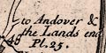
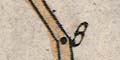
The beginning of each Road or Plate is at the bottom on the Left Hand, from thence you proceed upwards, the Road being bounded either by two Parallel black Lines, which shews the Road there is to be enclosed or hedged in on each Side; or else by two Parallel pricked or dotted Lines, which denotes the Road there to be over an open Common: Or lastly by a pricked Line on one Side, and a black Line on the other, which intimates the Road there to be open on the pricked Line side, and hedged or bounded on the black Line side.Routes are linked from sheet to sheet. For example, plate 52 mile 78 by a turning to Southampton Pl.54 and at the foot of a page From Romsey to Salisbury Pl.54.
When you are come to the Top of the first Bend of the Scrole, you are then to begin again at the Bottom of the next return of it, and so go upwards as before; and the like of all the rest.
If the Road does not terminate in the first Map, it is continued through the second, third, &c. as the Figures denote in the Miles will easily direct.
...
The little openings on either hand the Road shew the going out of other Roads, from the Road there described, the Name against it telling you to what Place it goes.
Senex's explanation:-
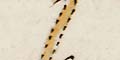
The black Dotts or Points placed in the Road, terminate the measured Miles, the Figures adjoined signify the Number from that Place, whence the Mensuration began.
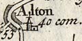
Beside the Numbers of measured Miles, you have at every noted City or Town the Number of computed Miles inserted near it; as from London to Oxford measures 55 Miles, when its computed Distance is but 47 com. (com. every where standing for computed.)These partly correspond to John Ogilby's use of horizontal direct distance, dimensuration, and vulgar computations. So how was the computed distance computed?
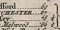
The Road from LONDON to POOL in DORSET SHI.Note that Poole, from this plate, has three distances from London:-
Commencing at Alresford in ye Southampton Road Pl.54
Alresford .......... 60
WINCHESTER ......... 67
Rumsey ............. 78 3/4
Castle Malwood ..... 86 1/2
Ringwood ........... 96 1/2
Knaston ............ 104 1/4
Pool ............... 110 1/2
Direct horizontal distance 100 m.
With a branch from Pool to Lemington
Christ Church ...... 10 1/2
Lemington .......... 22
And also from Southampton to Winchester.
110 1/2 by road by this route.
86 computed as marked by it on pl.52.
100 direct horizontal distance.


