 |
Road map features
Senex's Hampshire 1719-57 |
|
|
A few images can be clicked for more information.
|
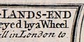 |
title cartouche: The beginning of each route has a title
in a plain box, the sides curved to fit within the scrolls of
the route maps. Only the first plate of a long road has a
title cartouche giving the name of the road. (eg: pl.25)
|
|
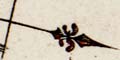
north point: Each scroll has a north point to gives its orientation.
|
|
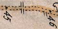
scale: The strip maps have no stated scale; roads are marked
at 1 mile intervals. A scale can be estimated; about:-
1 to 140000
2-2.5 miles to 1 inch
|
|
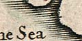
coast shaded: The coast line, where it appears, at
Southampton for example, is emphasised by shading (eg pl.54 mile 0).
|
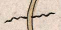 |
rivers: are shown by a wiggly line, somtimes with
the river name. Senex's explanation:-
Brooks, Rivers, Hills and Woods, are described by the common
Characters used for them in Maps.
|
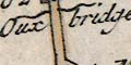 |
bridges: A bridge is shown by the river interrupting the
road; eg pl.52 mile 82 over the River Blackwater 3 miles SW of Romsey.
Oux bridge
|
|
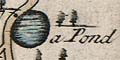
ponds: A pond might be shown, with shading. (eg pl.52 mile 77)
a Pond
|
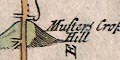 |
hills: are indicated by lumpy hillocks.
|
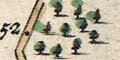 |
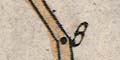
woods & forests: Trees are drawn in groups to indicate
woods or forests (eg pl.54 mile 52); they do not seem to have been
used randomly as decoration. A wood or forest might be named.
|
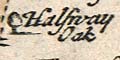 |
trees: A lone tree might be drawn and named, for example on the
road from Southampton to Romsey at about the halfway point
(pl.54 mile 4):-
Halfway Oak
|
|
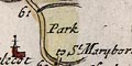
parks: are shown by a ring of fence, for example
outside Whitchurch, Hampshire (pl.25 mile 60).
|
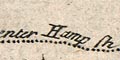 |
county: County boundaries are shown by a dotted line,
with annotation, for example, from Surrey, (pl.54 mile 43):-
reenter Hamp sh.
|
|
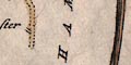
The county name is printed vertically along the side of each
scroll (eg pl.30 mile 48). Senex says:
The Name of the Countrey you travel
in is every where engraved along the
Side of the Scrole.
|
|
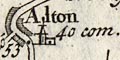
settlements: Settlements on the route are drawn by groups
of blocks indicating the size of the place and perhaps giving some
idea of street layout.
|
|
roads: Roads are the main element of these maps. The
road distance from London is given each mile.
|
|
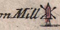
miscellaneous: John Senex's strip maps show incidental
features beside the road, what the tourist might or should
notice, perhaps. There are: windmills, paper mills, ancient
monuments, schools, posts, crosses, fortifications, chapels,
etc.
|


