scale

Senex's Hampshire 1719-57

Miles John Senex's road maps of Hampshire have no scale line or other formal indication on the maps.

The scale is implied by the markings on the roads:-
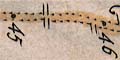
The black Dotts or Points placed in the Road, terminate the measured Miles, the Figures adjoined signify the Number from that Place, whence the Mensuration began.
Scale The scale of the road maps has been estimated by measuring the straighter segments of road from mile spot to mile spot. Badly kinked lengths were not measured. The measurements are small, and therefore inaccurate, ie measuring 10mm or so plus or minus 0.2mm has an error of 2%. By measuring a lot of segments and averaging, the error in the average is reduced.

The strip map scale is, assuming a modern statute mile, about:-
1 to 140000 2-2.5 miles to 1 inch
The measurements made are listed below, mm per mile segment.


     pl.25     pl.30     pl.52     pl.54

     10.8      11.2      11.5      11.8
     45.7 (4)  10.2      12.3      11.9
     11.4      10.4      11.7      11.7
     23.6 (2)  10.7      10.3      23.3 (2)
     24.5 (2)  32.8 (3)  12.6      12.1
     11.9      11.6      12.2      12.6
     12.0      11.2      10.9      36.4 (3)
     11.7      37.6 (3)  34.0 (3)  12.7
     35.4 (3)  11.7      24.4 (2)  12.0
     11.8      11.9      23.0 (2)  11.0
     12.6      13.0      11.5      11.1
     10.8      10.8      11.9      11.9
     13.0      11.9      12.2      24.0 (2)
     24.9 (2)  32.9 (3)  12.1      36.0 (3)
     12.3      35.6 (3)  13.6      11.4
     11.0      21.3 (2)  11.0      11.6
     11.8      33.1 (3)  24.1 (2)  35.5 (3)
     13.1      12.0      12.1      12.7
     12.7                10.2      11.2
     11.9                11.0      11.6
     24.8 (2)            11.1      11.5
     12.3                12.0      12.2
     12.0                11.7      12.9
     26.9 (2)             9.4
     12.9                11.6
                         23.6 (2)
totals
     421.8     329.9     372.0     369.1
     35        29        32        31
Total:-
     1492.8mm for 127 miles, average 11.75mm = 1 mile
     scale 1 to 136915.


Senex's Hampshire 1719-57, contents
Map features
General index
Old Hampshire Mapped