 |
settlements
Senex's Hampshire 1719-57 |
|
| settlements |
Settlements on the route are drawn as blocks beside the road,
indicating the size of the place and perhaps giving some idea of
street layout; these settlements might not include the church
which would have been there. A settlement off the route might
be indicated by a drawing of a church - that is what would be
visible from the route. An important house might be shown by a
drawing of a house.
Most places are named. The labelling font does not provide a
reliable guide to the importance or size of the place.
However:
|
 |
city: A city has whole areas of buildings; labelled in
italic block caps; eg:-
WINCHESTER
Example on pl.52 mile 12.
|
|
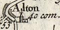
town: A town has building blocks along the road, plus a
church; labelled in upright lowercase; eg:-
Alton
Example on pl.89 at mile 53.
|
|
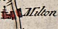
village: A village is drawn with buildings along the
road, plus church; labelled in italic lowercase; eg:-
Milton
Example on pl.52 at mile 15.
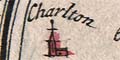
Off the road there is just a church; labelled in italic
lowercase; eg:-
Charlton
Example on pl.30 at mile 60.
|
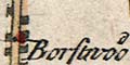 |
hamlet: A hamlet has a few single blocks beside the
road; labelled in italic lowercase; eg:-
Borstwood
Example on pl.54 at mile 76.
|
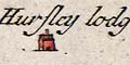 |
house: A house is a building; labelled; eg:-
Hursley lodge
Example on pl.52 at mile 74.
|


