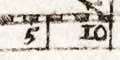
Scale line
Simmons's/Jenner's Hampshire 1635-43dividers
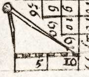
Estimating from the scale line, 11mm, the map scale is about:-
1 to 1500000A better estimate of scale can be made from town positions, comparing known town-town distances, using DISTAB.exe. The map scale is about:-
23 miles to 1 inch.
1 to 1600000The map maker's mile is probably an old english mile = 1.10 statute miles, BUT this is too small a map to give a reliable estimate of the size of the old english mile.
25.5 miles to 1 inch.
A pair of dividers are drawn over the scale line. These are distorted; to make them fit the space one leg is much longer than the other.


