Settlements

Simmons's/Jenner's Hampshire 1635-43
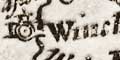
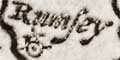
settlements Settlements are marked by a dot and circle with a tower.

Cities are labelled in lowercase upright text.

Towns are labelled in lowercase italic text.
Each town in the table of distances, left side column, is given a location, its cardinal or half cardinal sector on the map - once you've turned the map to read it. Eg:-
Rumsey S.W.
Odyam N.E.
In the second instance there is a mismatch of place names in the table and on the map, this is not as helpful as it might have been.

spelling: place names are spelled differently in the map and in the column and row of the table of distances; fitting three different spellings into such a small piece of paper is an achievement. Places in one are not always in the other.

The reason for this confusion is that the towns in the table of distances are those originally used by Norden, 1625, copied by Simmons, 1635-36 and again used here in this edition by Jenner, 1643. The places on the map are chosen in 1643, presumably without reference to the table.

Disconcerting for the traveller!

The places used in map and table are listed below.
(Places outside Hampshire are not listed.)
map
(today's name)
table location    miles from London
AultonAltonN.E.75
AndeverAndoverN.W.60
BasingstokBasingstokeN.E.42
BeaulieuS.W.73
Bighton
WalthamB. WalthamS.E.57
BramshotN.E.[ ]
Calshot cast
ChristchurchChrist-ChurchS.W.86
Caston
(ie Easton)
FarhamFarehamS.E.63
Fording-Bridge
Fording-bridge
S.W.77
Froyle
Hertford bridgeN.E.33
HavantHavantS.E.55
Heckfield
Howgton
(ie Houghton)
Hurst ca
Husborn
(ie Hurstbourne Priors)
Ibsley
Kimpton
KingesclereKingesclereN.84
Linkford
LemingtonLymingtonS.W.74
MicheldoverN.56
Netley
AlresfordAlresfordeN.E.62
OdiamOdyam
Odiam
N.E.39
OvertonOvertonN.55
PeterfeldPetersfeildE.48
Porchester
PortesmouthPortesmouthS.E.66
RingwoodRyngwood
Ringwood
S.W.86
RumseyRumseyS.W.65
S. HamptonS. HamptonS.65
Suthwick
Steep
StockebridgeStokebridgeN.W.61
Sutton
TitchfeildS.E.58
Tuston
The Vine
Wade
Whit-churchN.60
WickhamS.E.56
WinchesterWinchester
Wingfeld
(ie Winchfield)


Simmons's Hampshire 1635-43, contents
Map features
General index
Old Hampshire Mapped

Map HMCMS:FA1999.20