 Kennet and Avon Canal Kennet and Avon Canal |
 |
|
|
|
MILE 37
|
Burbage and Savernake, Wiltshire : KAC37.00=KAC38.00 |
|

|
KandAC mile 37
|
|
|
|
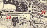
KandAC mile 37 - OS 1inch map, early 19th century
|
|
|
... did you know that moorhens paddle across canals, ducks paddle
along them ...
|
|
|
The Kennet and Avon Canal from mile 37 to 38 is at its summit level,
it passes Burbage Wharf. The Great Western Railway line the south west
is on the south of the canal. The towpath is on the south side.
|
|
|
|
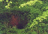
An outflow into the canal, from field drainage or a stream? just east
of Burbage Wharf Bridge.
|
|
|
|
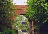
Burbage Wharf Bridge, Burbage
|
|
|
|
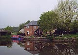
Burbage Wharf, Burbage
|
|
|
|
KandAC winding point 37.24
|
|
|
|
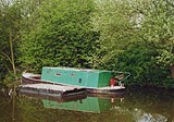
BWB work boat Alder, and a pontoon, moored below Burbage Wharf
|
|
|
The trees to the north are Leigh Hill Copse.
|
|
|
Parish boundary Burbage - Savernake: SU21946346
|
|
|
On the south is Ram Alley Copse; on the north Square Copse, Long Copse
and Crooks Copse.
|
|
|
|
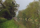
Looking westwards towards Cadley Lock.
|
|
|
|
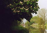
Horse chestnut, Aesculus hippocastanum, flowering all over the
towpath.
|
|

|
Kennet and Avon Scrapbook 2000
|
|