 Kennet and Avon Canal Kennet and Avon Canal |
 |
|
|
|
MILE 68
|
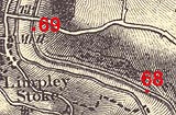
Winsley, Wiltshire : KAC68.00=KAC69.00 |
|

|
KandAC mile 68
|
|
|
|
KandAC mile 68 - OS 1inch map, early 19th century.
|
|
|
|
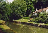
A desirable canalside residence, at Murhill.
|
|
|
... hanging on the side of the hill, beneath the woods, above the
river ...
|
|
|
The Kennet and Avon Canal from mile 69 to mile 70 runs level up on the
north side of the Limpley Stoke Valley, the River Avon and the railway
are lower down, various roads track along the hillsides. The towpath
is on the south side.
|
|
|
On the steep hillside the pressure of land water and earth threatened
the canal, causing blow outs and leaks. In the long pound, John Rennie
installed 18 pairs of stop gates to be ready for disasters and
maintenance.
|
|
|
The section of canal about here subsided in October 1954, and was
drained by British Rail, becoming the Dry Section - until restoration
completed 1978.
|
|
|
|
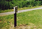
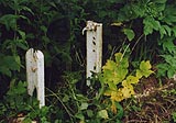
Milepost 68.
|
|
|
|
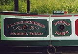
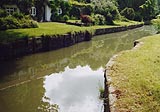
Murhill Quarry Wharf, Winsley
|
|
|
|
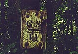
Frame of a wince, and the pawl for the ratchet, once used to pull the
plug from the bed of the canal.
|
|
|
|
There are/were stop gates at about 68m 7ch.
|
|
|
The woods to the north are Murhill Wood; up above is Winsley village
and the minor road from Bradford-on-Avon towards Bath. Secluded houses
inhabit the woods, some close by the canal. Off the towpath the bank
falls steeply to the river. Across to the south is Freshford, served
by another tiny railway halt.
|
|
|
|
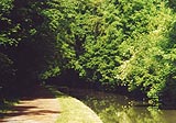
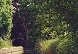
Canal, secluded in Murhill Wood.
|
|
|

|
There is a stop groove at about 69m 36ch.
|
|
|
|
Milepost 68 II
|
|
|
At the end of the mile the canal turns northwards, still following the
Avon in its valley. You might glimpse Limpley Stoke Station, which is
now a private house, with the railway still running by the fenced-off
platform. And you can hear the water over a weir at Limpley Stoke.
|
|
|
|
Canal, just eastward of Limpley Stoke Bridge.
|
|

|
Kennet and Avon Scrapbook 2000
|
|