

report by Edmund Dummer and Thomas Wiltshaw
HMCMS Map Collection inventory entry
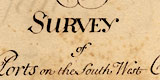
Report, descriptive text and charts, A Survey of the Ports on the South West Coast of England from Dover to the Lands-end, made by Edmund Dummer and Captain Thomas Wiltshaw, Royal Navy, 1698.
Made together with Captain James Conaway and Captain William Cruft, Masters of Trinity House at Deptford.
The bound volume has manuscript maps with descriptions of particular ports and harbours, some towns being shown in plan. The harbours surveyed, original spellings, are:- Rye, Pemsey, Cookmere, New-haven, Shoreham, Arundell, Southampton &c., Bussleton, Beauley, Lymington, Christ Church, Poole & Purbeck, Weymouth & Melcomb Regis, Exmouth, Dartmouth, Fowey, Falmouth and Helford.
A SURVEY of the Ports of the South West Coast of England from Dover to the Lands-End
- 3 are known in the British Museum - Sloane MS3233
- 3 in the National Maritime Museum
- 1 in the Royal Geographical Society
- 1 in Hampshire CC Museums Service (HMCMS)
- where is the ninth?
Facing the title page of the HMCMS copy of the report is a bookplate, a coat of arms and crest with motto:-
DEO DUCENTEand the engravers mark:-
[Exdriel] Sculpt.Below the bookplate an owner has pasted a slip cut from a sale catalogue. The book was lot 824 and assessed as:-
... very neatly drawn, an official manuscript.
In the transcriptions some freedom has been taken with the layout where strict line-by-line transcription (with space slash space, / , to denote newline) would make a nonsense.
Note that the letters in the tables of particulars refer to letters in the charts.
Robinson, A H W: 1962: Marine Cartography in Britain: Leicester University Press
report by Edmund Dummer and Thomas Wiltshaw