

report by Edmund Dummer and Thomas Wiltshaw

TQ9417; Landranger, 1:50000 Ordnance Survey map 189


Incapable of
use for ye Navy
1st.


report by Edmund Dummer and Thomas Wiltshaw
|
|
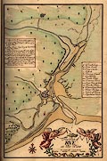
South Coast Harbours 1698
report by Edmund Dummer and Thomas Wiltshaw |
|
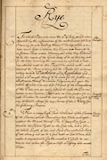
Rye, East Sussex:
'haven'; mouth of the River Rother, at Camber, running into Rye Bay in
the English Channel. TQ9417; Landranger, 1:50000 Ordnance Survey map 189 |
| images: click to enlarge | |
|
|
|
| transcript of text pages |
|
| Rye |
|
|
Rye Surveyed Incapable of use for ye Navy |
To which Place wee came the 5th: of July 98 and were Assisted by the information of the most Ancient and best Observing Persons dwelling there, Who acquainted us in how much beeter Condition this Haven was known to be in former Times within Memory and what they Esteemed to be the reason of the Great decay of it, at this day and for the better discerning the inconveniences and Evills it hath been attended with to this Time, Wee viewed with much exactness the Barrs without, and the Banks and inclosures within towards Winchelsea and Appledoor and caused a Draught thereof to be made for the further illustration thereof to Com~on Judgement, and upon the whole of what wee saw and Observed of the Circumstances of this Place, wee are easily induced to make this Determination in our Opinion; That it is in no Case proper for a safe Harbour to resort to, nor capable to be improv'd by any tollerable charge for any Services of the Navy for the following Reasons. |
|
Reasons thereof 1st. |
There is a very high Sand Westward of the Entrance of the Haven, which Runs above two Miles in Length without the Mouth thereof; The Channell or Gutt towards the Haven lyeth on the East side, and is for the whole Length of the said Sand, One continued Barr of not above 4 and soe to 2 foot depth at Low Water, and makes it impracticable for the smallest Vessells to venture in but when the Tyde is Aloft or Lifting and smooth Water. |
|
2ly. |
The Harbour within likewise at Low Water time is all Dry Sand except some Gleeting of Freshes from the Country, and all the Space of Water that is therein when the Tyde is out, lyes in the very entrance of the Haven, and just within it capable only of Floating a few Fisher Boates. |
|
3ly. |
The encroachments and Inning of the Lands upward in the Country, and the infinite Mass of Matter that Floates in the troubled Sea, wth. wch. all Weathers, and Tydes are Constantly Working to fill the same, have almost shut the Sea out of this Haven And wee doubt it would be very difficult to propound an effectuall means to remove it, unless it may be possible to be brought to pass to give the Sea the same freedom of Flux and Reflux, as it is presumed by Antient Tradition to have had for near 30 Miles into the Country tho' now Confin'd to less then 3 Miles Course that way, But the Propriety of Sundry Persons and the Policy of the Servers in severall Ages past, have wholly Dam'd it out, and doubtless will be very unwilling to abandon the Wast wch. have been from time to time taken in at great Expences, Therefore Wee look upon this Haven as entirely lost, at least in noe Condition to be Esteemed for any Services of the Navy as Wee have before Observed. |
|
|
museum inventory notes and transcription of the chart |
|
|
summary relating to this harbour |
|
|
South Coast Harbours 1698
report by Edmund Dummer and Thomas Wiltshaw |