|
FA1997.73:-
|
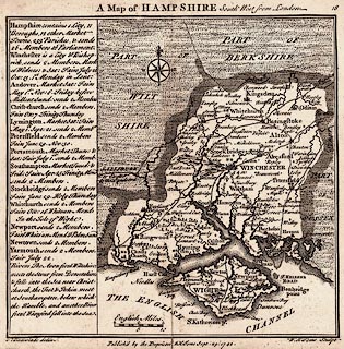
Map, uncoloured engraving, Map of Hampshire South West from London, scale
about 12 miles to 1 inch, Hampshire and the Isle of Wight, drawn by Thomas
Badeslade, published in Chorographia Britanniae, by William Henry Toms, Union
Court, Holborn, London, 1742.
|
|
map feature:-
|
not coloured & scale line & compass rose & roads & settlements
& rivers & county & forests & coast form lines |
|
scale line:-
|
10 miles = 21.4 mm |
|
inscription:- |
printed -on- top
A Map of HAMPSHIRE South West from London
|
|
inscription:- |
printed -on- bottom
[T] Badeslade delin. / Publish'd by the Proprietor W H Toms Sept. 29. 1742.
/ W H Toms Sculpt
|
|
dimension:- |
wxh, sheet = 18.5x16cm |
|
wxh, plate = 156x157mm |
|
wxh, map = 148x144mm |
|
scale = 1 to 750000 ? (1 to 752030 from scale line assuming statute mile) |
 |
|

|
Map Group -- Badeslade 1742 -- with Research Notes
|
 |
|
|
town names:-
|
|
Hampshire
|
Hampshire
|
|
map name
|
modern name
|
|
Alton
|
Alton
|
|
Andover
|
Andover
|
|
Basingstoke
|
Basingstoke
|
|
Waltham
|
Bishops Waltham
|
|
Christ Church
|
Christchurch
|
|
Farham
|
Fareham
|
|
Fording Bridge
|
Fordingbridge
|
|
Gosport
|
Gosport
|
|
Havant
|
Havant
|
|
Kingsclear
|
Kingsclere
|
|
Lymington
|
Lymington
|
|
Alresford
|
Alresford
|
|
Odiam
|
Odiham
|
|
Petersfield
|
Petersfield
|
|
Portsmouth
|
Portsmouth
|
|
Ringwood
|
Ringwood
|
|
Rumsey
|
Romsey
|
|
South Hampton
|
Southampton
|
|
Stockbridge
|
Stockbridge
|
|
Whitchurch
|
Whitchurch
|
|
Winchester
|
Winchester
|
|
 |
|

| top of page |
| MN: 9.11.2002 |


