|
FA2003.8:-
|
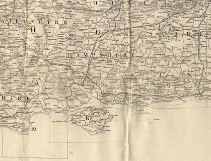
Index map, uncoloured engraving, Index to the Ordnance Survey of England and
Wales, south part, Index I, for sheets 1 to 84, scale 10 miles to 1 inch,
published by the Ordnance Survey, London, mid 19th century.
|
|
There is a list of plate numbers and names; the sheets needed for Hampshire
coverage are - 8 Dorking, 9 Brighton, 10 Isle of Wight, 11 Winchester, 12
Basingstoke, 14 Devizes, 15 Salisbury, and 16 Poole.
|
|
There are lists of Agents for the Sale of Ordnance Maps, for London and for the
country.
|
|
inscription:- |
printed -on- lower right
INDEX / TO THE / ORDNANCE SURVEY / OF / ENGLAND AND WALES
|
|
inscription:- |
printed -on- bottom
Printed from an Electrotype / Price Two Shillings
|
|
inscription:- |
printed -on- label on cover
Index I.
|
|
scale line:-
|
50+10 miles = 150.1 mm |
|
dimension:- |
wxh, folded = 12.5x22.5cm |
|
wxh, sheet = 95x65.5cm |
|
scale = 1 to 633600 ? (nominal) |
 |
|

|
Map Group -- OS 1810s Old Series -- with Research Notes
|
 |
|

| top of page |
| MN: 21.7.2003 |


