 Map Group COWLEY 1743


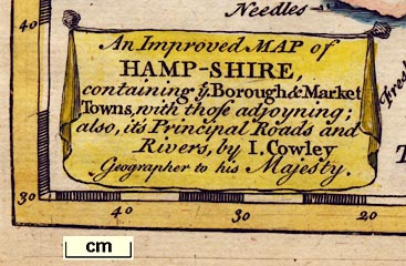
title cartouche
map maker

An Improved MAP of HAMP-SHIRE, containing ye Borough & Market Towns, with those adjoyning; also, it's Principal Roads and Rivers, by I. Cowley Geographer to his Majesty.

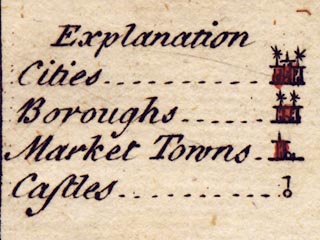
Printed upper left is:-
Explanation
Cities ... [circle, buildings, asterisks]
Boroughs ... [circle, fewer buildings, asterisks]
Market Towns ... [circle, tower]
Castles ... [circle, flag]The asterisks are not explained, but of maps in this period they usually denote the number of members sent to Parliament by a borough.
compass rose

The map has a simple compass rose, a circle with cross lines for the cardinal directions, north indicated by a fleur de lys, east by a cross.
Up is a about 5 degrees east of north.

Deg. W. Long. from London.
scale

English Mileschequered and labelled at 2 mile intervals. 10 miles = 18.8mm gives a scale 1 to 856034 assuming a statute mile. The map scale is about:-
1 to 860000
14 miles to 1 inch
sea plain
THE CHANNEL
St. Hellens Road
Hampton Water
coast shaded
coast form lines
headlands
foreshore

The coast is shaded, but has form lines up Southampton Water and in larger harbours.
A few headlands are labelled:-
Hengistbury Head
Ram's headThe spits at Hurst and Calshot are drawn with dotted lines, like sandbanks.
Harbours are not labelled.
castles

Hurst Cast.
Calshot Cast.
S. Andrews Cast.
bridges
ferries

Loddon R.
Tees R
Wallop R.
Itchin R.Bridges are mostly not drawn, but suggested by the crossing of a road over a river.
Portsey Bridgis labelled on one or other of two roads that cross to Portsea Island.
Three bridges are drawn, detached from any principal road. Two across the River Meon, about Titchfield, one across the Wallington River at Fareham.
A road drawn from Lymington goes through Beaulieu and ends at the coast opposite Southampton. This suggests the existence of a ferry, the Hythe Ferry.
forests

New Forest

The county boundary is a dotted line, on the map studied this is tinted. The detached part of Hampshire in West Sussex is not inlcued on the map.
Adjacent counties are labelled, eg:-
Part of WILTSHIREand their boundaries shown for a short way out from the Hampshire border.

WINCHESTER
SOUTHAMPTONupright lowercase text, eg:-

Alton
Stokebridge
Allesford

Sutton [Sutton Scotney]
HarndonOnly villages that are (necessary?) way points on a principal road are drawn.
Andover - 2
Christchurch - 3
Lymington - 1
Petersfield - 2
Portsmouth - 2
Southampton - 2
Stockbridge - 2
Whitchurch - 2
Winchester - 2
road distances

The 'principal roads' in the county are drawn by a double continuous line. The routes displayed by Cowley differ from Ogilby's routes, although the important routes are still in evidence - London to Portsmouth, to Southampton, to Lands End, to Weymouth, and to Poole.
Destinations out of the county are labelled, eg:-
to London

to Senan
to TruroA group of these labels, west of the county, is supported by a pointing hand symbol.
Road distances from place to place are marked beside the road. Thus Basingstoke to Alton is 8 miles, Alton to Petersfield 10, etc. The distance from Lymington to Southampton is given, 8 miles, on the road that needs a ferry at Hythe.
Distances outwith the county are not given.


Published in 'A New Sett of Pocket Mapps Of all the Counties of England and Wales. Shewing, The Situation of all the Cities, Boroughs, Market-Towns, and most considerable Villages, with the Distances between each. Also the Rivers and Roads both direct and across. Together with A Separate Mapp of England, a Plan of the Roads, and a Chart of the Channel. London: Printed for R. Dodsley in Pall-Mall, and M. Cooper in Pater-noster Row. 1745.'
Published in another edition 1745.


