|
Research Notes
 Map Group DAWSON 1832
|
 |
|
Dawson 1832
|


|
|
|
Map, Hampshire, and boroughs in the county, scale about 6.5 miles to 1 inch,
by Robert Kearsley Dawson, Lt RE, drawn for the Reform Bill, 1832 and printed by Hansard, London, 1832.
|
|
The map studied is probably a copy made for the Report of the Municpal Corporation Boundaries Commission, 1937. It is in the Map Collection of Hampshire CC Museums Sevice, item HMCMS:FA1999.65.
The 'snip' images are taken from an identical map, tho' tinted differently, item HMCMS:1991.13.1.
|
|
Printed by lithography; an early use of the process in England. The borough maps are Andover, Winchester, Christchurch, Lymington, Petersfield,
Portsmouth, Southampton.
The map size is: wxh, sheet = 28.5x35cm.
|
 |
MAP FEATURES |
 |
ELECTORAL DATA for Hampshire Towns |
 |
PUBLISHING HISTORY |
 |
ITEMS in the Collection |
 |
|
| MAP FEATURES |
|
title
map maker
engraver
|
Printed upper left is:-

Hampshire
in an Old English type.
Printed lower right, signature:-
Robt. K. Dawson. Lieut.
R.E.
Below the scale, lower left, is:-
R Martin, Lithog. 124, High Holborn &
51 Carey St.
|
scale line
scale
|
Printed lower left is a:-

Scale of Miles
labelled at 1 mile intervals; 6 miles = 47.3 mm giving a scale
1 to 204145 assuming a modern statute mile; the map scale is
ablout:-
1 to 200000
3 miles to 1 inch
|
orientation
north point
up is N
|

Printed on the left above centre is a simple north point; N-S
line, E-W line, North marked by an arrow.
|
coast line
|

The sea and coast line are plain.
|
rivers
|
Only river estuaries are shown, no river inland.
|
county
|

The county boundary is a dash dot line, tinted. There is no
labelling of adjacent counties.
|
hundreds
|

Hundred boundaries are dashed lines, and might be tinted. The
hundred areas are labelled in upright block caps, eg:-
ODIHAM HUND.
FAWLEY HUNDRED
Detached parts of hundres are labelled in lowercase, eg:-
Bishops Sutton Hundred
on the east boundary of the county.
|
settlements
electoral data
|
Only necessary settlements are marked; plus a few extras whose
relevance is not immediately apparent. Perhaps accompanying text,
which we do not have, might make their inclusion clear.
|
city
town
|
Borough towns have the red circle, maybe with an outer circle,
showing they return 1, or 2, members to Parliament; labelled in
upright block caps, eg:-

WINCHESTER [returns 2 members,
principal place of county election]

ANDOVER [returns 2
members]

PETERSFIELD [returns 1
member]
Other towns are marked by a few blocks by their roads;
labelled in upright lowercase text, eg:-

Alton
Basingstoke
|
|
village
|
The few other places are marked by a cross, perhaps for a
church; labelled in italic lowercase text, eg:-

Cheriton
Bramley
|
roads
|

A network of roads is drawn by double lines.
|

| top of page |
 |
|
| ELECTORAL DATA |
for Hampshire Towns |
electoral data
|

A dot dash line tinted red is the proposed boundary between
divisions of the county, labelled:-
NORTHERN DIVISION
SOUTHERN DIVISION
This is (?) the division boundary which came into force with
the Reform Act 1832. A second dot dash boundary is engraved on
the map, tinted green on one copy. This might be an alternative
division?
|
table of symbols
|
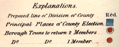
Printed lower right is:-

Explanations.
Proposed line of Division of County ...
Red.
Principal Places of County Election ...
[red square]
Borough Town to return 2 Members ...
[red circle with outer circle]
Do. ... Do. ... 1 Member ... [red
circle]
 
  
The symbols might be combined as at Winchester which has a red
circle with an outer circle, embedded in a red square.
|
|
The towns shown are, with their number of members of
Parliament:-
|
|
Alton
|
|
ANDOVER - 2
|
|
Basingstoke
|
|
Bishops Waltham
|
|
CHRISTCHURCH - 1
|
|
Fareham
|
|
Fordingbridge
|
|
Havant
|
|
Kingsclere
|
|
LYMINGTON - 2
|
|
New Alresford
|
|
Odiham
|
|
PETERSFIELD - 1
|
|
PORTSMOUTH - 2
|
|
Ringwood
|
|
Romsey
|
|
Stockbridge
|
|
SOUTHAMPTON - 2
|
|
Whitchurch
|
|
WINCHESTER - 2
|

| top of page |
 |
|
| PUBLISHING |
HISTORY |
|
Published in 'Plans of the Cities and Boroughs of England and Wales:
shewing their boundaries as established by the Boundaries' Act, passed 11th July
1832: together with Outline Maps, shewing, the divisions of counties, the
principal places of election, and the polling places, as established by the same
Act. In two volumes. London: Printed by James & Luke G. Hansard & Sons, near
Lincoln's Inn Fields, 1832.' |
|
The maps were the byproduct of the Reform Bill 1831, and relate to the Boundaries Act 1832. |

| top of page |
 |
|
|
ITEMS |
in HMCMS Map Collection (scanned item in bold)
|

|
HMCMS:BWM500 -- map
|

|
HMCMS:FA1987.7 -- map
|

|
HMCMS:FA1991.13.1 -- map
|

|
HMCMS:FA1991.13.2 -- map
|

|
HMCMS:FA1998.183 -- map
|

|
HMCMS:FA1999.65 -- map
|

|
HMCMS:WOC5598.4 -- map
|

| top of page |
|
 |
All Old Hampshire Mapped Resources |

 Map Group DAWSON 1832


