|
Research Notes
 Map Group HARRISON 1788
|
 |
|
Harrison 1788
|


|
|
|
Map, Hampshire, scale about 6 miles to 1 inch, drafted by Haywood, engraved
by Sudlow, by John Harrison, 115 Newgate Street, London, 1788; published
1791-92.
|
|
These notes are made from a copy of a map of Hampshire by John
Harrison, 1788. The map studied is in the Map Collection of
Hampshire CC Museums Service, item HMCMS:FA1996.34.
|
 |
MAP FEATURES |
 |
OGILBY ROUTES |
 |
PUBLISHING HISTORY |
 |
REFERENCES |
 |
ITEMS in the Collection |
 |
|
| MAP FEATURES |
|
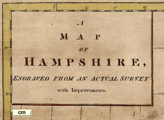
title cartouche
plain cartouche
|

The map title is printed in a plain cartouche at the top
left:-
A MAP OF HAMPSHIRE, ENGRAVED FROM AN
ACTUAL SURVEY with Improvements.
|
map maker
engraver
|
Printed across the bottom is:-
Haywood Del
Engraved for J. Harrison, 115, Newgate
Street, as the Act directs, Decr. 16, 1788.
Sudlew Sculp.
The draughtsman's name is spelled variously Heywood and
Haywood for different maps in the whole atlas.
|
orientation
compass rose
|

The map has a simple compass rose, just the four cardinal
points (N,E,S,W) with north marked by spear head, no letters or
words. The N-S line is oriented to but offset from the longitude
grid; the E-W line lies along a latitude grid line.
|
lat and long grid
|

Latitude and longitude are indicated by a chequered border to
the map, numbered at degrees and every 5 minutes, on all four
sides of the map. The latitude/longitude grid is drawn on the
map.
Calculations from the positions of the scale marks show that
the ratio of latitude to longitude scales is about 1.55. This is
near the necessary value for a 'square' plot, 1.58 at the
latitude of Hampshire.
Sheared rectangular latitude and
longitude scales. The angle of the 1 degree W meridian is about 2.7 degrees E of
N and is quite apparent on the map. The 51 degree N parallel is
horizontal on the page.
|
|
These figures make no inference about the positions of places
on the map. It is likely that Harrison copied a map and applied
lat and long scales to it. No attempt has been made to see how
well he fitted the scales. Both Kitchin 1751 large and Harrison
1788 might have been copied from the same source map. Their lat
and long scales can be overlaid, using computer graphics, and
look almost identical.
|
scale line
scale
|

There is a scale line: 12 miles, chequered in miles, numbered
1..12, labelled:-
English Statute Miles, 69 1/2 to a
Degree.
Assuming a modern mile the map scale would be about:-
1 to 300000
5 miles to 1 inch
But a better estimate of the map scale can be got from town
positions, comparing to known town-town distances using
DISTAB.exe. The map scale is about:-
1 to 370000
6 miles to 1 inch
|
index grid
|
This map has no index grid. Calculations have been made to
overlay the National Grid system on the map. For details, and
how this grid can be used compare early county maps,
and to index places, see:-
|

|
Old Hampshire Mapped
|
|
By comparing the headings of the towns from the centroids, and averaging, it is calculated that NGR north is 3.4 degrees from map north.
|
|
The grid references of the map borders were calculated as:-
bottom left SY859640
top left ST800616
top right TQ161698
bottom right TV219722
|
|
This could be useful to present the map in a GIS system.
|
sea area
sea plain
|
The sea is plain.
|
coast line
coast form lines
|

The coast is drawn with form lines.
|
coastal defence
castles
|

Most of the coastal defence castles are marked on Harrison's
map:-
Hurst Castle
Calshot Castle
Netley Cast
St Andrews Cas
Worth Cast.
Sth. Sea Castle

And two military defensive fortifications in the Portsmouth
area are shown.
Cosham Fort
at the crossing from the mainland to Portsea Island; and the
fortifications around Portsmouth dockyard.
The map is far too small to show the exact layouts, but the
distinctive zigzag shape of the walls of an artillery fort,
polygonal wall, bastions and ditches, is clearly suggested. This
style of fortification with ditches, bastions, etc was developed
in the 16th to 18th centuries and became obsolete during the 19th
century. Note that the fortifications face landwards. They are
there to protect the Royal Navy's dockyard from an invading force
from landward.
|
rivers
bridges
|

Rivers are drawn by wiggly lines; some named, eg:-
Avon R
Beauley R
Oux R
Most of Hampshire's major rivers are shown, but coverage does
not appear to be entirely systematic. There are some little
streams shown which could have been left out, and some not shown
which could have been included.
Many road river crossings are drawn, but it is not clear that
a bridge, rather than a ford, is implied. At Winchester it looks
like a bridge.
|
relief
hillocks
|

Hills are drawn by little lumpy hillocks.
|
beacons
|

Beacons are shown by a tower on a hill with flames coming from
the top. Harrison shows only two beacons; this is two centuries
after the Armada, the beacon system is no longer important. This
map, 1788, is just a few years too early to show the new
telegraphs, shutters in 1796 then semaphores in 1812, being
organised by the Admiralty for signalling between London and
Portsmouth.
|
forests
woods
trees
|

Forests and woods are drawn by groups of small tree symbols;
circle and trunk.
|
parks
|

Parks are shown by a ring of fence palings, usually with
trees. The shape is not just a conventional circle, but attempts
to show the shape of the park Some parks are named, eg:-
Tremanton Park
Idlesworth Park
|
county
|

The county boundary is a dotted line. In the example studied
the boundary has been coloured pink, plus different colour for
each adjacent county.
|
hundreds
table of hundreds
|

The hundred boundaries are drawn by a dotted line.
A table of hundreds is printed at one side, keyed to areas on
the map by numbers. Detached parts of hundreds are explicitly
labelled.
Reference to the Hundreds.
No.
1 Christ Church ...
Hundred
2 Ringwood ... Do.
3 New Forest ... Do.
etc
The Bosmere/Portsdown hundred boundary is unclear on the map;
it probably continues down the river to the coast. Similarly the
hundred boundary between New Forest/Christchurch probably follows
down the river to the coast.
|
settlements
|
Settlements are marked by 2x1 rectangular blocks, ie
buildings. The grading of settlements is uncertain, but you can
try to judge from the sizes of block symbols and the type of text
used for the name.
|
|
city
|

blocks along a road; labelled in upright block caps, eg:-
WINCHESTER
|
|
|
|
town
|

blocks along a road; labelled in upright lowercase text,
eg:-
Alresford / Thu.
|
|
|
|
village
|

L shape block, ie a church?; labelled in italic lowercase
text, eg:-
Upr. Wallop

or, blocks along a road; labelled in italic lowercase text,
eg:-
Badsley
|
|
|
|
hamlet
|

simple block; labelled in italic lowercase text, eg:-
Prestrow

The symbol may be just a house
Bear Ho.
|
|
|
|
castle
|

two towers etc, eg:-
Odiham Castle
|
|
|
market days
|

The market day is printed alongside some of the towns on the
map, eg:-
WINCHESTER W & Sat
Fareham Wed.
|
roads
|

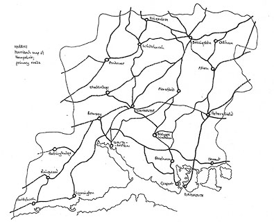
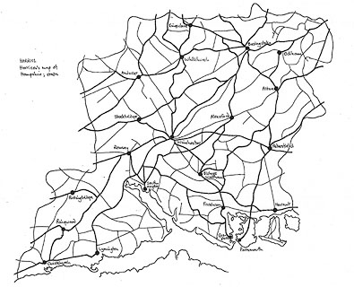
Harrison's map shows a network of roads drawn by double lines.
The roads are graded; more important roads are drawn wider and
have one line bold, lesser roads are narrower. On the map studied
the main routes are coloured yellow, the minor routes left plain.
There are numerous roads; the density of both major and minor
roads is worth consideration.
There are some apparent oddities. The road SE from Andover
meets the River Test distinctly offset from what looks like its
continuation towards Winchester. What is missing is the zigzag of
the [current] B3420 alongside, across, between braids, across,
and alongside the Test in its broad valley. How this leaves the
18th century traveller we can only guess; confident that there's
bound to be a way across?
|
| Route diagram:- |

|
| Route diagram:- |

|
|
|
canals
|
Although Harrison is aware of canals, they are mentioned in
the introduction to his atlas, they are not shown on this
map.
|

| top of page |
 |
|
| OGILBY ROUTES |
|
|
|
Harrison show numerous roads on his map of Hampshire. As the
route maps published by Ogilby one hundred years earlier, 1675,
are of particular interest a superficial comparison between
Ogilby's routes and Harrison's roads has been be made; there is
not enough accurate detail to allow close matching. Ogilby's
routes are referred to by their plate numbers; routes 25, 26, 30,
32, 39, 51, 53, 81, 83, 97.
|
Ogilby 25
|
This route can be followed, roughly, as a major road entering
from Surrey at Blackwater, via Hertford Bridge, to Basingstoke,
continuing through Laverstoke to Whitchurch. From Whitchurch a
minor road through Down Husborn shows Ogilby's route while
Harrison's major road goes further south.
|
Ogilby 26
|
On Harrison's map this route leaves Andover as a major road
via Abbotts Anne going SW to the Wiltshire border. The road goes
through Middle wallop, between Lower (ie Nether) and Upper
Wallop, whereas Ogilby's route goes through Nether Wallop.
|
Ogilby 30
|
This route appears as a major road entering from Surrey near
Liphook, through Petersfield, southwards via Harndon, crossing to
Portsea Island at Cosham. The major road continues all the way to
Portsmouth.
|
Ogilby 32
|
This route shows as a minor road from Andover, via Monkston
and Quarley to the Wiltshire border. Harrison's equivalent starts
more northerly to Weyhill before turning SW.
|
Ogilby 39
|
This route can be followed as a major road from Petersfield
westwards through Langridge and Bramdam, to Winchester. How close
Ogilby and Harrison are across Magdalen Down is hard to tell.
|
Ogilby 51
|
This route appears as a major road entering from Farnham,
Surrey, via Bentley, to Alton. From Alton it can only be followed
as a minor road to Alresford. From here it appears as a major
road via Morested but missing Twyford, crossing the Itchin near
Albrook House, and entering Southampton from the NE. The
continuation back northwards to Rumsey is shown as a major
road.
|
Ogilby 53
|
The first part of this route SW from Basingstoke is followed
by one or other minor roads but is picked up by a major road
through Cranborn on to Stockbridge. Starting out from Stockbridge
as a major road it is shown as a minor road going on SW to cross
the Wiltshire border.
|
Ogilby 81
|
This route shows as a major road entering from Berkshire
across the Auborn River near Kingsclere, before turning SE to
Basingstoke. A major road seems to follow the route to Alton,
then Petersfield, then E to the Surrey border.
|
Ogilby 83
|
This route has a small segment in Hampshire, shown by a minor
road through South Tidworth.
|
Ogilby 97
|
This route is drawn as a minor road from Alresford to
Winchester across Magdalen Down. From Winchester it appears as a
major road through Hursley, to Rumsey, then SW via Ragged Row and
Malwood to Ringwood, and from there to the Dorset border. The
extra part of route 97 from Poole eastwards to Christchurch, them
Lymington, shows as a major road. The extra part of route 97 from
Southampton northwards to Winchester, entering via St Cross, also
shows as a major road.
|
| A comparison to Ogilby's routes can be found in:- |

|
Old Hampshire Mapped
|

| top of page |
 |
|
| PUBLISHING |
HISTORY |
|
Published in 'Maps of the English Counties with the Subdivisions of
Hundreds, Wapontakes, Lathes, Wards, Divisions, &c. To which are add two folio
pages of Letter-Press, to face each Map; descriptive of the extent, boundaries,
rivers, lakes, canals, soil, mines, minerals, curious plants, husbandry, and
every curiosity that is nearly connected with the maps. The whole containing the
most useful, entertaining, and instructive selection of the kind, that has yet
appeared at the price of 3l. 3s. London: Printed by and for John Harrison,
No.115, Newgate-Street, M,DCC,XCI.' ie 1791. |
|
The atlas has a title page, a list of 'The Distances from Place to Place in Miles, on
the Principal and cross Roads in England and Wales; with the Situation of each
Gentleman's Seat.'; the atlas size is 20 1/2 x 16 ins. |
|
Published in second edition, price 2l. 2s., 1792. |
|
Published in a 'General and County Atlas ...', 1815. |
|
Harrison earlier published 'The Atlas to Accompany Rapin's History of England',
1784-89, which may have had a map relevant to Hampshire.
|

| top of page |
 |
|
| REFERENCES |
|
|
|
Harrison, John: 1791 & 1792: Maps of the English Counties: (London) |
|
Norgate, Martin & Norgate, Jean:
1997: Notes from Harrison's Map of Hampshire: Hampshire County
Council Museums Service:: ISBN 1 85975 160 1
|
|
also see:-
|
|

|
Old Hampshire Mapped
|

| top of page |
 |
|
|
ITEMS |
in HMCMS Map Collection (scanned item in bold)
|

|
HMCMS:FA1988.3 -- map
|

|
HMCMS:FA1993.14 -- map
|

|
HMCMS:FA1996.34 -- map
|

|
HMCMS:FA1997.113 -- map
|

|
HMCMS:FA1997.119 -- descriptive text
|

| top of page |

 Map Group HARRISON 1788


