 Map Group HOGG 1784


monumental cartouche
map maker
publisher

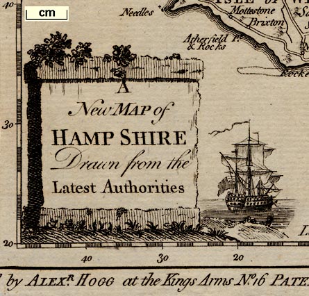
A New map of HAMPSHIRE Drawn from the Latest AuthoritiesThe cartouche is a block of stone with foliage creeping over the top; and a ship sailing away beside it. The ship looks like a small three masted man-of-war flying a large ensign.
Printed at the bottom:-
Published by ALEXR. HOGG, at the Kings Arms, No.16 PATERNOSTER ROW.

The coat of arms of the Southampton is printed upper left.
compass rose

The map has a simple compass rose; a plain circle with lines for the cardinal directions, north marked by a fleur de lys, east by a cross, and dotted lines for the half cardinal directions.

Printed in the map borders are scales of latitude and longitude for a recatmgular projection; chequered at 2 minute intervals, labelled at 10 minute intervals. Printed by the lower border is:-
Longitude West from London

British Statute Miles20 miles chequered in miles, then at 5 mile intervals. 20 miles = 49.6 mm is 1 to 648929, assuming the modern mile, ie about:-
1 to 650000
10 miles to 1 inchAn estimate of the scale can be got from town positions, comparing known town-town distances using DISTAB.exe. The map scale is about:-
1 to 660000
10.5 miles to 1 inch

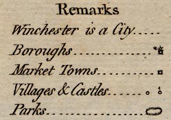
Remarks
Winchester is a City
Boroughs ... ... ... [fig]
Market Towns ... ... [fig]
Villages & Castles . [fig] [fig]
Parks .. ... ... ... [fig]The figures are discussed below.
sea plain
Spitheadis labelled, also:-
Southampton Water / Trisanton Bay
coast form lines

The coast has form lines which continue into harbours and estuaries.
castles

Hurst Cast
Calshot Cast.
Soutsea Cast
lakes
bridges

Rivers are drawn by wiggly lines, broad at the mouth, tapering inland. Braiding might be shown, for example on the Test. Some rivers are labelled, eg:-
Avon R.A lake is shown at Farnborough.
Roads on the map generally interupt rivers, loosely implying a bridge. A clear example, see Eling. But the engraver is not careful; at Christchurch the river and road both continue through the intersection implying a ford, but I do not believe this is interntional. At Bursledon or Hamble? the river interupts the road, implying a ferry? Again I think it is a lack of care.
hillocks

Small indistinct hillocks shaded to the east signify hills. These are grouped, but do not depict the bones of the county at all well or reliably. The road from Petersfield towards Alton is drawn running along a ridge of hills:-


There is a village symbol labelled:-
Beaconsomewhere near Popham Beacons?
forests

The map has some groupings of very little tree symbols. There is some labelling:-
NEW FOREST
East Bere Forest

The table of symbol gives an oval of fence palings for a park. This symbol, in various shapes and sizes is found over the map. None (?) is explicitly labelled.

The county boundary is a dotted line. Adjacent counties are labelled, eg:-
WILT SHIRE
streets
Place labelling is a muddle of engraving, across feature symbols ...

WINCHESTER

AndoverOtherwise just a circle which the table says is a village; labelled upright lowercase text, eg:-
Odiam

Froyle

Roads are drawn by a double line.
roman roads

Three roads have dotted lines; the Portway, the roman road east from Winchester, and the road south from Silchester.


Published in 'The New British Traveller; Or, A Complete Modern Universal Display Of Great-Britain And Ireland: Being A New, Complete, Accurate, And Extensive Tour Through England, Wales, Scotland, Ireland, the Isles of ... Comprising all that is worthy of Observation in every County, Shire, &c. ... Being calculated equally to please the Polite - entertain the Curious - instruct the Uninformed - and direct the Traveller. ... Being Really The Result Of An actual and late General Survey, accurately made by a Society of Gentlemen, Each of whom has undertaken that Part for which his Study and Inclination has more immediately qualified him. And Including A Valuable Collection of Landscapes, Views, County-Maps, &c. ... The Whole Published Under The Immediate Inspection Of George Augustus Walpoole, Esq. Assisted ... By David Wynne Evans ... Alexander Burnett ... and ... Robert Conway ... And Others ... London: Printed For Alex. Hogg, At The King's-Arms, No.16 Paternoster-Row, 1784.'
Published in a new edition about 1792.
Published in a new edition about 1793.
Published in another edition 'The New And Complete English Traveller; Or, a New Historical Survey and Modern Description of England and Wales. ... and ... a descriptive Account of a Tour through the English and Scottish Islands ... Written ... by a Society of Gentlemen ... Revised, Corrected, And Improved, by William Hugh Dalton, Esq. ... Enriched and Embellished with ... correct Maps ... London: Printed for Alex. Hogg, No.16, Paternoster-Row; and Sold by the Booksellers of Bath, Bristol ... and by all other Booksellers and Newsmen in England, Wales, Scotland, and Ireland.' about 1794.


