 Map Group JEFFREYS 1775


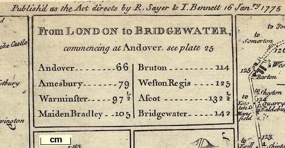
plain cartouche
publisher
distances from London

Printed upper centre is a plain rectangular cartouche:-
From LONDON to BRIDGEWATER, commencing at Andover. see plate 25.The title is followed by a table of places and distances from London:-
Andover ... 66 / Amesbury ... 79 / Warminster ... 97 1/2 / Maiden Bradley ... 105 / Bruton ... 114 / Weston Regis ... 125 / Ascot ... 132 1/2 / Bridgewater ... 142This sheet is plate 32, the plate number printed top right. This strip map is equivalent to Ogilby's sheet 32; a branch off the London to Lands End road which is sheets 25, 26, etc.
Printed at the top is:-
Publish'd as the Act directs by R. Sayer & J.Bennett 16 Janry. 1775.
north point
up is destination

Each scroll of the strip map has a north point; N-S line, E-W line, North marked by a fleur de lys, east marked by a cross. Each scroll is printed showing a stretch of road from bottom to top.
1 to 84000
1 1/3 miles to 1 inch
ponds

Rivers might be drawn by a wiggly line crossing under the road. None on this sheet is labelled.
A pond or lake might be shown by an outline with shading as at mile 101-102:-
Sherewater head
hillocks

Hills beside the road are drawn by hillocks. These might be under the road presumably indicating descents and descents, which are not differentiated; or a whole series under the road indicating a ridge way:-

or a whole series on either side the road indicating a valley route:-

Some hills are labelled, eg:-
Scratchbury Hill
Cotley Hillboth in Wiltshire, and
Anstrow Hillwithout any hillock.
forests
trees

Amport GroveOther labels for woodland are not accompanied by trees, eg:-
Selwood Forest
Hampshir
WILTSHIREThe change of county is also labelled at the boundary, eg:-

Enter Wiltshire

Andover

MonkstonA village off the route is more likely to have a symbol, block, circle, and cross, labelled as:-

Abbots Ann Ch.A circle with a flag marks:-
Way hill
distances from London

The road is drawn by a double line, solid for fenced, dotted for unfenced. The road runs up the middle of each strip, a rectangular 'scroll'. Distances from start, London for the main routes, is marked at 1 mile intervals by a spot in the road, and a figure.
Junctions are drawn clearly, often labelled with their destination, large or small, eg;-
to Winchester
to Wallopand perhaps with the plate number of another strip map, eg:-
to Salisbury Pl.26at the junction half a mile on the west side of Andover.
Some side routes are noted at the bottom of the map:-
A Road goes from Warminster to Heytsbury 8 1/2 distant. & another to Shipton Mallet 10 1/2 distant. From Bruton a Road goes to Exeter and another to Tiverton.
windmills

Walton Millin Somerset.
tumuli
henges
Burrows or Small HillsAn array of shaded blocks portrays a henge:-

Stonehenge remarkable Remains of Antiquity


PREFACE
THE many new Turnpike-Roads and communications between the different towns in this Island, few of which are taken notice of in any of the books of the English Roads, some even pointing out Roads which are no longer in a passable condition, was sufficient reason for attempting a new and more correct description. The plates for the following Work were originally intended for an account of these roads in french; but, falling into the hands of the late Mr.JEFFERYS and the editor, it was thought they might be the foundation of a work in English. And, to render it the most compleat and exact of any yet published on this useful plan, all materials on the subject have been consulted, and the best information possible procured from persons well acquainted with the Roads; so that it contains several thousand names of place son and adjacent to the Roads, which are not to be found in any other collection: and, besides its exhibiting a view of the principal Highways as they now exist, there are added all the smaller branches leading from the considerable Market-towns to each other, together with a very full Index, which, we flatter ourselves, will make this Book the best direction for travelling through this Kingdom.


Published in 'The Roads of England Delineated; or, Ogilby's Survey, Revised, Improved, and Reduced to a Size portable for the Pocket, by John Senex, F.R.S. Being an Actual Survey of All the Principal Roads of England and Wales; Distinctly Laid Down on One Hundred and one Copper-Plates; ... With the Additions of some Roads newly drawn, which were omitted by Mr. Ogilby, and several necessary Corrections made in Others; together with a great Number of explanatory References, by which this Edition of the Roads is rendered of more general use to Travellers.' 1775.
The maps are published earlier, with title cartouches in French in 'The Roads through England, or Ogilby's Survey Revised, Improved, and Reduced by Senex ...' by Le Rouge, Augustin Street, Paris, France, 1769.


