
 Map Group KITCHIN 1763


The Hampshire map size is: wxh, sheet = 22.5x28.5cm; wxh, plate = 26x20cm; wxh, map = 256x192mm.


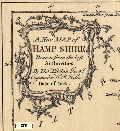
baroque cartouche
map maker

A New MAP of HAMP SHIRE, Drawn from the best Authorities. By Thos. Kitchin Geogr. Engraver to H.R.H. the Duke of York.
compass rose

There is a compass rose with star points for the cardinal directions and lines for the half cardinal directions. North is marked by a large fleur de lys, east by a cross. Up is north on the sheet.
scale

British Statute Miles 69 to a DegreeThe scale line is chequered progressively; 10 miles = 37.7mm gives a scale 1 to 426882. The map scale is about:-
1 to 430000
7 miles to 1 inch
lat and long grid

There are scales of latitude and longitude scales for a recatngualr projection printed in the map borders; chequered at 5 minute intervals, labelled at 10 minute intervals. Printed upper left:-
Longit. West from London.Reading form the scales the:-
longitde, Winchester = 1d 13.4m W approxsuggesting a prime meridian several minutes west of Greenwich, perhaps at St Paul's?
The 51d N parallel and 1d W meridian are drawn across the map; a minimalist graticule.
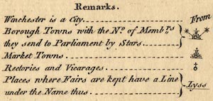
Remarks
Winchester is a City
Borough Towns with the No. of Membrs. they send to Parliament by Stars ... [circle, buildings, tower, stars]
Market Town ... [circle, buildings, tower]
Rectories and Villages ... [circle and cross]
Places where Fairs are kept have a Line under the Name thus ... [Lyss underlined]
sea plain
sandbanks
Spithead
Haling Bay
Southampton Water or Trissanton BaySandbanks are indicated by a dotted outline, but none labelled.
coast shaded
headlands

The coastline is shaded, this shading extended into harbours and estuaries. A headland is labelled:-
Hengistbury Head
castles
fortifications

Hurst Cast.
Calshot Cast.
Southsea Cast.The last, only, has a circle and flag symbol.
The town of Portsmouth has a wide circle drawn around it and although this does not look like polygonal artillery fortifications, that is probably what it is meant to represent.
ponds
bridges

Itchen R.
Avon R.
Tees R.Some ponds are drawn, and might be labelled, eg:-
Fleet Pondor not, for example Alresford Pond.
Bridges are implied by roads crossing rivers, and perhaps being named, For example:-
Knights Bridge
Eversley Bri.
London BridgeRoad exits on the northern borders of the county.
hillocks

Relief is suggested by little hillocks, shaded to the east, perhaps in groups. A few are named, eg:-
Black Hill [N border near Whitsbury]Some of the groups of hillocks are in rows, with a ridge road on top, for example from Colemore to Petersfield.
A down might be labelled, without a hill symbols, eg:-
Basingstoke Down

Popham Beacon
forests
vegetation

Woodland areas are shown by groups of trees, perhaps labelled:-
New Forest
East Bere Forest
Chute ForestOr there might be a label without any tree symbols, eg:-
Harewood ForestOther woods and forests are not noticed.
Dots are used to suggest undergrowth.
A couple of commons or heaths are noticed, for example:-
Havant Chace
Aldershot Common

Headley Park
Hackwood Parkwhich has all those elements.

The county boundary is a dashed line. Adjacent counties are labelled, eg:-
WILTSHIRE
DORSET SH.and their boundaries drawn for a short distance from the Hampshire border.
The detached part of Hampshire in West Sussex is not included.
Very little is shown outside the county for continuity; Downton, Lopcombe Corner, Farnham, ...
fairs
streets

WINCHESTERhas a circle outline containg a rudimentary street plan, I think. It has two stars for members of Parliament.

Andover
OdihamUnderlined if it has a fair, eg:-
AltonAn exception is labelled in italic block caps:-
SOUTHAMPTON

Upper Wallop
Meon StokeThe cross might be at any angle to the circle; Up Wallop has it upright, Meonstoke has it at 4o'clock.
If the place has a fair its name is underlined, eg:-
Weyhill

Merdon
Barcley Kings

Marwelland might be within a park, as at Headley Park.
Alton
Appleshaw
Barton Tracey
Beaulieu
Broughton
Chilton Candover
East Meon
Emsworth
Eversley
Fordingbridge
Hartley Maudit
Heckfield
Liphook
Mattingley
Sutton Scotney
Tangley
Weyhill
Wickham
Andover 2
Christchurch 2
Lymington 2
Petersfield 2
Portsmouth 2
Southampton 2
Stockbridge 2
Whitchurch 2
Winchester 2
roman roads
roman towns

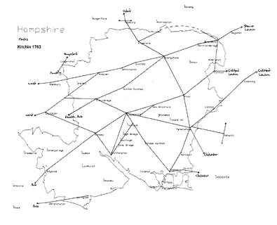
A network of roads is drawn over the county using double lines. These might be continuous or dotted, presumably for fenced or unfenced roads. Main roads are not distinguished. Most of the Ogilby routes are shown, but not completely; there are other main routes as well.
Destinations outwith the county are labelled, eg:-
to London
From Salisbury
From PoolAt least one road junction is named (in Wiltshire):-

Labcomb CornerSome roman roads are labelled:-
Port Way
Roman Way [Salisbury-Winchester]
Ikenield WaySilchester roman town is drawn with a circle, outer ring, and hachuring, labelled in lowercase italic text:-

Silchester
tumuli
Canuts Barroweast of Upper Wallop. Just there to fill space?


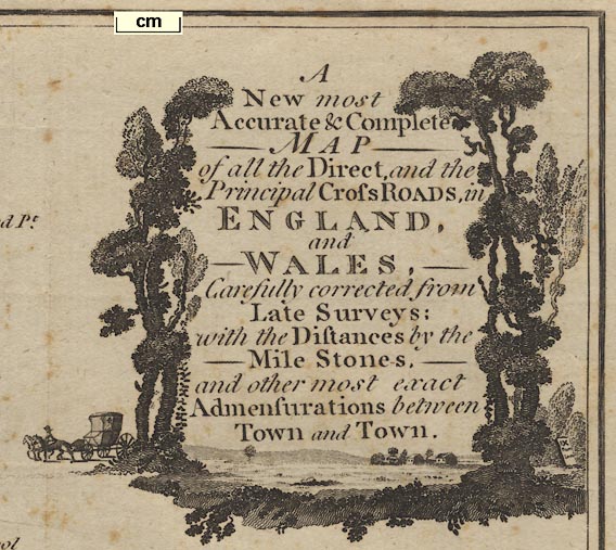
scenic cartouche
map maker
IX From Londonto the right. The title is:-
A New most Accurate & Complete MAP of all the Direct, and Principal Cross ROADS, in ENGLAND and WALES, Carefully corrected from Late Surveys: with the Distances by the Mile Stones, and other most exact Admensurations between Town and Town.The maps shows England Wales; plus parts of Scotland, Ireland and France in outline, with a few border or coastal places.
No where on the map is any note of the map maker's or engraver's names. The style of the map is late 18th century.
compass rose
up is N
1 to 1900000
30 miles to 1 inch
road distances
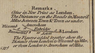
Printed upper right under the title is:-
Remarks
Cities in New Print as London,'new' appears to mean upright rather than italic, and:-
The Distances on the Roads in Measur'd Miles, between Town and Town as under.
[diagram of a part road with places and distance figures]The figures added together shew the Distances from London to Wicomb 29 Miles, or from London to Amersham 26 Miles.
sea plain
ENGLISH CHANNEL
Spithead
coast shaded
Severn R.
Thames Riverbig enough to be labelled, rivers are not shown on the map. By Hampshire 'Spithead' rather than a river name is given.
SCOTLAND
FRANCE
table of counties
REFERENCES TO THE COUNTIES
1 Northumberland
2 Cumberland
3 Durham
...
51 Hampshire
...in a scroll cartouche.
Winchester
village
Andover
Harndon
Alton
Andover
Basingstoke
Waltham [Bishops Waltham]
Christchurch
Fareham
Fording Br. [Fordingbridge]
Gosport
Havant
Kingsclear [Kingsclere]
Lymington
Alresford [New Alresford]
Petersfield
Portsmouth
Ringwood
Rumsey [Romsey]
Southampton
Stockbridge
Whitchurch
WinchesterThere are other places as well, necessary as nodes in the road network.
road distances
Most of the 'Ogilby' routes are shown, missing: a segment of Ogilby 51 between Alresford and Southampton, and the end segment of Ogilby 30 to Portsmouth. There are extra routes: Winchester through Stockbridge to Salisbury; Blackwater through Swallowfield to Kingsclere; and Winchester through Cosham to Chichester.
Road distances are marked in figures beside the road between towns (or villages). Whole miles or half and quarters are given, eg:-
12
8 3/4The stretch of road from Andover through Lopcomb Corner to Salisbury is labelled:-
The Hull


The map is like the map by Kitchin published volume 2 of:-
England Illustrated, Or, A Compendium Of The Natural History, Geography, Topography, And Antiquities Ecclesiastical and Civil, Of England and Wales. With Maps pf othe several Counties, ... Printed for R. and J. Dodsley, in Pall-Mall. MDCCLXIV.
KITCHIN'S most ACCURATE MAP of the ROADS of ENGLAND and WALES, with the Distances by the Mile-Stones, and other most exact Admensurations between Town & Town.
Frontispiece Vol.II.
Printed for R. and I. Dodsley in Pall-Mall.


Published in 'Kitchin's English Atlas; Or, A Compleat Set of Maps Of All The Counties of England and Wales, Containing all the Cities, Towns, Parishes, Rivers, Roads, Seats, and, in General, every other Particular that is usually sought for, or to be found, in Maps. The Whole engraved in the neatest and most accurate Manner, from Drawings after actual Surveys and other the best Authorities. By Thomas Kitchin, Geographer to his Royal Highness the Duke of York. London. Printed for J. Dodsley, in Pall-Mall,' 1765.


