 Map Group KITCHIN 1769


compass rose
up is N

Printed lower right is a plain compass rose; star points for the cardinal directions, lines for the half cardinal, North marked by a fleur de lys, east by a cross. The map is printed with North at the top of the page.
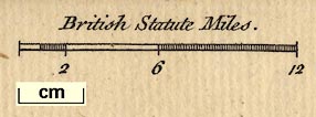
scale

Printed lower left is a scale line; chequered at 1 and 6 miles intervals labelled to match 2, 6, 12. The 12 miles = 42.6 mm gives a scale 1 to 453336. The map scale is about:-
1 to 450000
7 miles to 1 inchWhat miles are used has not been checked.
lat and long grid

The map's borders have scales for latitude and longitude; chequered at 1 minute intervals, labelled at 10 minute intervals. The top longitude scale is labelled:-
Longit. W. from London.The 1d meridian and the 51d parallel are drawn by straight lines across the map, interrupted so as not to confuse other stuff.
The map includes 0d 39m to 1d 55m W, 50d 38m to 51d 25m N; the county of Hampshire and the Isle of Wight. The longitude of Winchester is about 1d 18m W suggesting a prime meridian at Greenwich.

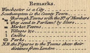
Remarks
Winchester is a City.
Southampton is the County Town.
[circle, towers, stars attached] Borough Town with the No. of Members they send to Parliamt. by Stars.
[circle, towers] Market Towns.
[circle] Villages &c.
[circle, flag] Castles.
[ring of fence palings] Parks.
N.B. the Figures to the Towns shew their distance from London.
sea plain
sandbanks
buoys
ENGLISH CHANNEL
Stokes Bay
Southampton Water or Trisanton BayForeshore shallows and sandbanks are shown by a dotted outline and some are labelled, eg:-
Christ Church Ledgewhich could be The Shingles. Also:-
Bramble Dry
MiddleTwo buoys are drawn as conical shapes, named:-

Horse Buoy
Dean Buoy
coast shaded
headlands
harbours

The coast line is emphasised by shading, which extends into harbours and estuaries. Some headlands are labelled, eg:-
Hengistbury Hd.
Spit HeadThe bigger harbours can be recognised, but they are not labelled.
castles

Hurst Cas.
Calshot Cas.
Southsea Cast.
ponds
bridges

Rivers are drawn by a bold wiggly line tapering inland. Braiding might be indicated, for example south of Stockbridge. All the major river systems seems to be drawn quite well, with tributaries, but ?none are labelled.
Some ponds are drawn, for example at Woolmer, with shading.
Bridges are suggested only by a road crossing and interrupting a river.
hillocks

Relief is suggested by groups of hillock symbols, shaded to the east. Although these are in groups it is not easy to follow what is being plotted. None seem to be labelled.
Popham Beaconattached to a circle symbol for a village by the road between Popham and Bullington.
forests

East Bere Forest / Havant Chace
New Forest

A few parks are shown by a ring of fence palings, which might enclose a tree or two, and might be labelled, eg:-
Hackwood Park

The county boundary is a dotted line.
H A M P S H I R Eis written across the map's area.
Adjoining counties are divided by dotted line and labelled, eg:-
WILT SH.The detached part of Hampshire in West Sussex is not shown. A few places outwith the county are included to provide continuity of road routes, eg Farnham, etc.
electoral data
distances
from London

WINCHESTERSouthampton is also shown in street plan style, but labelled in italic block caps. Both these places have two stars for members sent to Parliament.

Petersfield 56
Overton 53The number is the distance of the town from London.
Boroughs have stars for members sent to Parliament.
hamlet

Greatley
Bramley

A network of roads is drawn by double lines. Roads are not differentiated for size, nor for fenced and open roads.
Roads might be continued out of the county to a town etc, thus to Salisbury, Amesbury, Farnham, Midhurst, and Chichester. Or the road's destination might be given, eg:-
to London
From PoolMost of the old 'Ogilby' routes are represented, but no longer by simple lines of route. (route 83 is not included.)
roman towns

Silchester, where there are the remains of a roman town, is specially marked with its circle surrounded by a ring of ?hachures.


Published in 'Bowles's Pocket Atlas of the Counties of South Britain or England and Wales ... being the only Set of Counties, ever Published on this Plan, London. Printed for & Sold by the proprietor Carington Bowles, No.69 in St. Paul's Church Yard.' about 1778.


