 Map Group -- LETTS 1884


Published in 'Letts Popular County Atlas', 1884.
The map studied is in the Map Collection of Hampshire CC Museums service, item HMCMS:FA2001.139.


map maker

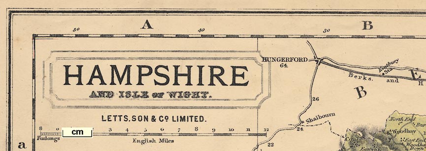
Printed in a plain title cartouche upper left is:-
HAMPSHIRE AND ISLE OF WIGHTbelow which:-
LETTS, SON & Co LIMITED.Printed at the bottom:-
LETTS, SON & Co LIMITED LONDON BRIDGE E C
compass rose
up is N

Printed upper right is a compass rose; no circle, star points for cardinal and half cardinal directions, lines for false points, North marked by a fleur de lys. The map is printed with North at the top of the sheet.
scale

English Mileschequered and labelled in miles, with a left extension divided in furlongs. The 12+1 miles = 77.6 mm giving a scale 1 to 269607 assuming a statute mile. the map scale is about:-
1 to 270000
4 miles to 1 inch

Printed in the map borders are scales of latitude and longitude for a trapezoid projection; chequered in minutes, labelled at 10 minute intervals. The bottom longitude scale is labelled:-
Longitude West of GreenwichAs well as can be read the:-
longitude, Winchester = 1d 18.2m Wwhich agrees with the accepted figure 1d 18.4m W.
The international agreement of Greenwich as the prime meridian was made at a conference in the United States 1884, the year this map was published. It was already well established as a prime meridian in use by many nations as well as Britain.
The map includes from 0d 23m to 1d 53m W, from 50d 31m to 51d 26m N; the whole of Hampshire and parts of Dorset which were Hampshire, and the Isle of Wight.

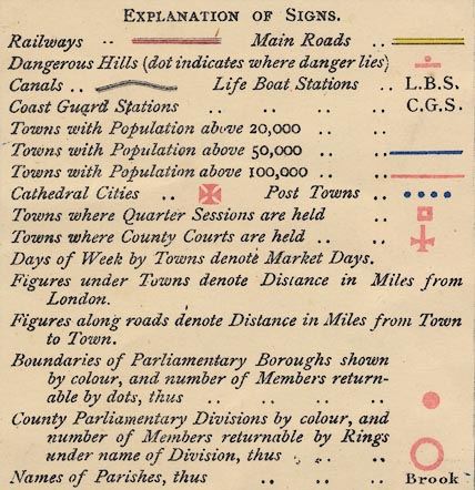
EXPLANATION OF SIGNS.
railways ... [triple line, tinted red] Main Roads ... [double line, tinted yellow]
Dangerous Hills (dot indicating where danger lies [red dot and bar]
Canals ... [triple line, light bold light] Life Boat Stations ... L.B.S.
Coast Guard Stations ... C.G.S.
Towns with Population above 20,000 ... [blank space]
Towns with Population above 50,000 ... [blue line]
Towns with Population above 100,000 ... [red line]
Cathedral Cities ... [red maltese cross] Post Towns ... [four blue dots]
Towns where Quarter Sessions are held ... [red square]
Towns where County Courts are held ... [red sword]
days of Week by Towns denote Market Days.
Figures under Towns denote Distances in Miles from London
Figures along roads denote Distances in Miles from Town to Town.
Boundaries of Parliamentary Boroughs shown by colour, and number of Members returnable by dots, thus ... [red dot]
County Parliamentary Divisions by colour, and number of Members returnable by Rings un name of Division, thus ... [red circle]
Names of parishes, thus ... Brook [upright lowercase text]
population
STATISTICS.
Population ... 593,487
Area in Acres ... 1,032,105
Gross Rental ... L3,278,906
Inhabited Houses ... 110,531
Poor Rate ... L31,705
Paupers ... 21,416
sea tinted
THE SOLENT
SOUTHAMPTON WATER
Stoke Bay
coast shaded
headlands
harbours
lighthouses
coastguards
lifeboats

The coast line is shaded.
Some headlands are noticed, eg:-
Hengistbury Head
Gilkicker Pt.and some harbours are labelled, eg:-
Key Haven
PORTSMOUTH HARBOURAt Southampton there are labelled:-
Docks / PierOn the end of Hurst Spit is labelled;-
Lightfor the ?two lighthouses there.
At intervals along the coast are letters:-

C.G.S.which stand for Coast Guard Station. there are quite a lot, for example at the west end of Hurst Spit, Lymington, Sowley, mouth of the Beaulieu River, Lepe, and places west and east of this group.
The letters:-
L.B.S.stand for Life Boat Station, for example at the south west tip of Hayling Island. The letters are quite hard to see as they are drowned in the sea tint and coast shading.
castles
fortifications

Hurst Castle
Calshot Castle
Netley Castle
Ft. Monkton
[fortifications at Gosport]
[fortifications at naval dockyard]

[fortifications at Portsmouth]
South Sea Castle
Cumberland FortWhat is not shown is interesting.
bridges
ponds

Rivers are drawn by a wiggly line tapering inland. Braiding might be shown, for example north and south of Ringwood on the Avon. Some rivers are labelled, eg:-
Avon River [Salisbury Avon]
Anton or Test River
Enborne
Itching River
Avon Water
R. StourAll the main rives of the county and many tributaries are shown. Following rivers is difficult in this densely drawn map.
Some bridges are noticed, eg:-
Knights Bri.on the Enborne.
Some ponds are labelled, eg:-

Woolmer Pond
Tanners Pond [N of Kings Sombourn]
hill hachuring

Quarley Hill
Longstock HillSome downs are labelled, eg:-
Broad Halfpenny Down
Corhampton Down

Beacon Lodge [W of Hordle]
Popham beacon
Beacon Hill [N of Exton]
forests
trees
NEW FOREST

Forest of Bere [East Bere Forest]

High Wood
Faccombe Wood
Wherwell WoodNot all forests are densely covered with trees, and undergrowth is suggested by dotting.
Notice the:-
Swanwick Elma placename or a tree name?

Burley Park
Hackwood Parkperhaps labelled by the house name, eg:-
The Vine

The county boundary is a dot dash line. Adjacent counties are labelled, eg:-
WILTSHIRERoads, railways, and significant settlements are drawn outside the county boundary to put Hampshire in its context. The transport features continue to the edge of the map border and occasionally beyond, for example Reading is included though it is outside the map border.
distances from
London
post roads
market days
courts
electoral data

WINCHESTER / 63Winchester has a red maltese cross for a cathedral city; is underlined by four blue dots to show it is a post town; has a red sword as a place where county courts are held; has a red square for a place where quarter sessions are held; has two red dots indicating it is a parliamentary borough returning two members to Parliament; and has blue letters for market days:-
W & SWednesday and Saturday.
The figure is the distance from London. The various added elements are not always easy to read, getting lost in the detail on the map.

Alton / 47with four blue dots for a post town; red sword for county courts; and letter:-
Tufor Tuesday market day.
SOUTHAMPTON / 74has four blue dots, two red dots, a red sword, letter F? for Friday market day; and is underlined in blue to show it has a population over 50,000.
PORTSMOUTH / 70has four blue dots, red sword, two red dots, market days:-
Tu Th & Sand is underlined in red for a population above 100,000.

Upper Wallop

Middle WallopItalic lowercase is used to label all sorts of features on the map.
road distances
turnpike roads

Roads are drawn by a double line, solid or dotted for fenced and unfenced edges. The roads are broad or narrow, some have a light and bold line, some are tinted yellow. It is not really clear how the various conventions add up. The yellow tint is declared for 'main roads' but can include a narrow as well as the includes broad roads:-

Dangerous hills are marked by a red dot and bar:-

The figures beside roads are distances, marked each two miles from a town towards another.
Some road junctions are labelled, eg;-
Lobcombe Cornerand less usefully:-
A Cross Rds.on Cranbury Common.
By some roads there are labels like:-
Vernham Dean Gate
Botley Gatewhich may refer to turnpike gates?

According to the table of symbols, railways are drawn by a triple line, tinted red. In practice the railways are drawn by a pair of double line, the rails, with cross lines for the sleepers. In places the cross lines have been forgotten; in other places the triple line is used. The red tint is printed out of registration.
Stations are marked by a dot, and labelled, eg:-
Station
Statn.
Sta.A railway might be labelled, eg:-
London & South Western Ry.

Basingstoke Canal
Andover Canal
Southampton Canal
Old Canal
Arundel Canal
Canal

Dog & Crook [Timsbury by Romsey]
West Meon Hut
Anchor Inn [Ropley]
tumuli
Kent Barrowsouth of Andover. The nearby hillforts of Danebury and Quarley are not noticed.
roman roads
Roman Roadon the line between Winchester and Salisbury. South of Kingsclere another piece of road is labelled the same, on the route from Silchester to Sarum.

Salt Works

Race Cou.on Worthy Down north of Winchester.


electoral data
table of hundreds

The boundary between thirteen parliamentary divisions is a dot dot dot dash line. The two main divisions are labelled:-
NORTHERN DIVISION
SOUTHERN DIVISIONcoloured pale green and yellow respectively. A red circle under the name of the division indicates the number of members returned to Parliament. The divisions are divided into hundreds, by a dotted line; note that parts of a hundred might be in different divisions. The hundred areas are labelled by a number referring to a table printed lower left:-
The LARGE FIGURES in body of Map refer to the DIVISIONS, HUNDREDS, and LIBERTIES, thus;-
ODIHAM DIVISION.
Crondal ... 1
Odiham (part of) ... 2
Holdshot do. ... 3
Bermondspit do. ... 4
Bentley ... 5
BASINGSTOKE DIVISION.
Holdshot ... 6
Barton Stacey ... 7
Overton ... 8
Chuteley ... 9
Basingstoke ... 10
Bermondspit ... 11
Odiham ... 12
KINGSCLERE DIVISION.
Evinger ... 13
Chuteley ... 14
Kingsclere ... 15
Basingstoke ... 16
Overton ... 17
Pastrow ... 18
ANDOVER DIVISION.
Andover Hund. ... 19
Pastrow ... 20
Thorngate ... 21
Kings Sombourn ... 22
Buddlesgate ... 23
Wherwell ... 24
Barton Stacey ... 25
ROMSEY DIVISION.
Thorngate ... 26
Kings Sombourn ... 27
Buddlesgate ... 28
Mansbridge ... 29
Redbridge ... 30
New Forest ... 31
WINCHESTER DIVISION.
Buddlesgate ... 32
Barton Stacey ... 33
Micheldever ... 34
Mainsboro' ... 35
Bountisboro' ... 36
Fawley ... 37
Bishops Waltham ... 38
ALTON DIVISION.
Fawley ... 39
Bishops Sutton ... 40
Shaldon ... 41
Alton ... 42
Selbourn ... 43
PETERSFIELD DIVISION.
Barton Stacey ... 44
Fawley ... 45
East Meon ... 46
Alton ... 47
Odiham ... 48
Finch Dean ... 49
FAREHAM DIVISION.
Portsdown ... 50
Bosmere ... 51
Havant Lib. ... 52
Fareham Hd. ... 53
Gosport & Alverstoke ... 54
Titchfield ... 55
DROXFORD DIVISION.
Bishops Sutton ... 56
Fawley ... 57
Meon Stoke ... 58
Hambledon ... 59
Bishops Waltham ... 60
SOUTHAMPTON DIVISION.
Mansbridge ... 61
Bishops Waltham ... 62
Baddlesgate [sic] ... 63
Dibden ... 64
Beaulieu .. 65
LYMINGTON DIVISION.
Christchurch ... 66
Ringwood ... 67
New Forest ... 68
RINGWOOD DIVISION.
Christchurch ... 69
Westover ... 70
Ringwood ... 71
Fordingbridge ... 72
New Forest ... 73
Breamore ... 74
ISLE OF WIGHT.
West medina ... 75
East do. ... 76Boroughs, towns sending members to parliament, are bounded by dotted line and tinted pink (I think).


