 Map Group MERCATOR 1595


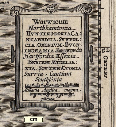
title cartouche
ANGLETERREPrinted in a title cartouche, middle right:-

Warwicum / Northamptonia / HUNTINGDONIA CA: / NTABRIGIA, SUFFOL: / CIA, OXONIUM, BUCK: / INGHAMIA, BEDFORdia / Hartfordia, Essexia / BERCERI MIDELSE: / XIA, SOUTHHA~TONIA / Surria, Cantium / SouthsexiaThe top of the cartouche is decorated with a ?bat.
labelled borders

SEPTENTRIO / ORIENS / MERIDIES / OCCIDENS
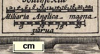
scale lines

Miliaria Anglica magnachequered at 2 mile intervals, 22 miles = 29.2mm is 1 to 1212519 assuming a statute mile, ie about:-
1 to 1200000and:-
parvachequered at 1 mile intervals, 20 miles = 24.1mm is 1 to 1335555, ie about:-
1 to 1300000making the same bad assumption. The map scale is about:-
20 miles to 1 inchUsing the latitude scale, 2 degrees latitude = 129.6mm is 1 to 1731985, about:-
1 to 1700000
27 miles to 1 inch
sea moire effect
sandbanks

The sea is engraved with a moire effect. A sandbank is shown as a dotted area off the east coast of Kent.

The sea between England and France is:-
OCEANUS BRITANNICIUSand either the sea area, or the nearby headland, is labelled:-
The Beacheoff Beachy Head.
coast shaded
harbours

The coast line is shaded.
A few harbours are labelled, eg:-

Rye haven
Orford havenand at least one headland:-
ye Nesse pointeoff Sussex.
bridges

Rivers are drawn by wiggly lines; a double line with some shading at the mouth, tapering to a single line inland. Rivers are mostly not named, but see:-

Tamessis fluA number of bridges are clearly shown by double line across a river. For example across the Thames in London; here perhaps meaning there is/are crossing/s rather than meaning there is one bridge? There are more bridges on the Thames; Staines, Feltenham, Henley. And some in Hampshire, eg:-

at Ringwood.
hillocks

A few little hillocks are drawn to suggest relief, fitted in between place names. They are not very helpfull? There is a range of hills representing the South Downs, and another the Berkshire Downs north of the Kennet, etc.

A very few trees symbols suggest woods. These are so crowded out by other features that it is difficult to see that they mean much at all.

The country is named by the page title:-
Angleterreon this French edition. The south east corner is shown, top left is about Birmingham. A corner of France is shown, labelled:-
GALLIAE PARSThis is in Latin as are county names on the map. (The French page title is outwith the map.)

The county boundaries are dotted lines. Where these run along a river the river and boundary are drawn side by side. Counties are labelled in Latin, eg:-
SOUTH SEXIA
SOUTHAMPTONIA

Settlements are positioned by a dot and circle, and all labelled in lowercase italic. Towns ahve a tower and/or buildings added to the dot and circle. Some circles appear to have a cryptic line attached, as used by other map makers in these early times to distinguish one sort of little settlement from another. Do not be mislead; I think they are pointers attaching the label to the circle, for example see Haling on Hayling Island. In other places the tail of the last letter of the label might be extended to attach it to its circle, for example Hurseborn in north Hampshire.


SOUTH: / AMTONIAThe title cartouche has 2 Hs.
bridges
Stour
Avon
Test
Itchen
Meon
Rother
Blackwater, Loddon
Enborneeach with tributary streams. None are labelled.
Bridges can be seen at:-
Christchurh (2 over Stour and Avon)
Iford (Stour)
Ringwood (Avon)
? (near Stoneham, Itchen)
Winchester (Itchen)
Fareham ( )
forests
The places named, t for town, v for village, are:-
Aberston [v]
Alresford [t]
Andover [t]
Aulton [t]
Basynstoke [t]
Bishops Waltha~ [t/v (2 symbols)]
Blackwater [v]
Calshot ca [castle]
Christchurch [t]
Eling [v]
Estrmyl [v (where?)]
Exburie [v]
Faran [t]
Fullington [v (Bullington)]
Haling [v]
Havant [t]
Hurseborn [v]
Kingeselere [t]
Leminton [t]
Newton [v (where?)]
Odiam [t]
Overto [v]
Porthmouth
Ringswood [t]
Rumsei [v]
S. Andros ca [castle]
Southamton [t]
Southwick [t]
Stokbridge [t]
Winchester [t]
[unamed] [Hurst castle]


