 Map Group MORDEN 1708


The sheet size is about 332x224mm, this was tipped in and folded in an atlas; plate size 169x209mm, map size to outer borders 167x206mm.
The Map Collection copy was folded in text pages torn from the atlas MAGNA BRITANNIA, published by Thomas Cox about 1738.
The page size of the book is 173x224mm.
A transcription of these pages can be found in:-


engraver

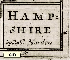
HAMPSHIRE by Robt. Morden.Printed lower left:-
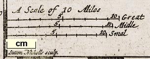
Sutton Nicholls sculp.
compass rose

Added by Herman Moll, 1708; circle with lines for cardinal points, North marked by a fleur de lsy, East by a cross.
hours from Greenwich

Left, bottom and right margins, chequered in 5 minutes, marked at degrees and 10 minute intervals.
Top margin

Minutes of Timemarked III, IIII, V, VI.
scale

3 scale lines, each 10 miles with divisions at 1 mile intervals, marked at 5 and 10.
A Scale of 10 Miles / Great / Midle / Smal10 Great Miles=38.4mm, scale 1 to 419100; 10 Midle Miles=36.2mm, 1 to 444570; 10 Smal Miles=34.1mm, 1 to 471948; all on the bad assumption of a modern statute mile; average scale about:-
1 to 445000
7 miles to 1 inch
coast shaded
sandbanks
headlands

Sea coast shown by horizontal shading carried into harbours and river mouths. Hurst and Calshot Castles are shown on sandbanks, pecked.
Hengistbury, Spit and Rams Heads are named.
Harbours are not named.
castles
St Andrews Ctower and flag, eg:-

Hurst C.
Calshot C
lakes
bridges
ferries

Rivers are shown by wiggly lines, tapering inland, perhaps starting as a double line, perhaps shaded in broad reaches. Braiding is shown south of Stockbridge and in other places. Some rivers are named, eg:-
Stour R
Test R ol Anton
Itchin R or AlreA lake is shown at Highclere.

Bridges are shown here and there. Their inclusion is confused by the possible addition of roads by Moll, 1708. (The earlier version is not available in the Map Collection for comparison.) Some are marked more neatly than others.
A dotted double line is drawn across
Hampton Watercontinuing the line of a road. Considering how it defaces other marks this probably added by Moll? The ferry is named:-

Hith Ferry
hillocks

Quarley & Hills
Butser hillis labelled but no hill shown.
Test woodis labelled.

Parks are shown by a small ring of fence palings, for example at Hursley.

The county boundary is given by a dotted line. The surrounding counties are labelled in plain lettering.
table of hundreds

Hundred boundaries are indicated by dashed lines, the hundred labelled with a number referring to a table upper left:-
Hundreds in Hamp Shire

WINCHESTERChichester has no cross, but is outwith the county ...

AlresfordAn old name might be given, eg:-
Ringwood ol Regnum
Silcester Old Vindonum
Southampton ClausentumSome towns have 1 or 2 stars attached to their symbol which probable indicate which are boroughs sending Members to Parliament. (The number of stars does not, as it does elsewhere, indicate the number of Members.)

BentlyThere may be some variation in lettering size but it does not look a reliable guide to importance.
A circle and name might be used for any feature.
A name might not have a circle, perhaps marking a feature which is not a settlement, eg:-
Onion Holeby Silchester, referring to the finds of onion pennies here, mentioned by William Camden.

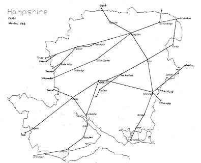
Roads are shown by a double line. It is believed that some of the roads in this version of the map were added by Herman Moll about 1708, even though some were drawn by Morden about 1690s. The roads appear to be confused, perhaps from their dual authorship.
Roads are labelled to show where they go, out of the county; some of this labelling is upsidedown! eg:-

to Senan
to PoolThe labelling seems to have been started on the east side of the county, and the map rotated as each label was added: when the west of the map is reached, it is upsidedown.


Saltworks

Bascomb Coperas


THE Maps mentioned in the former Proposals (though they were Design'd according to the newest Surveys very Correct, and contained all the Towns that were mentioned in Camden's yet) were not thought Large and Comprehensive enough, by some Judicious and Ingenious Gentlemen that assist in the Work, Who think it proper and Necessary to have the Maps of every County full as Large as this Sheet will admit, ...
Britannia et Hibernia, Antiqua et Nova

Published in 'Fifty Six New and Accurate Maps of Great Britain, Ireland and Wales; With All the Direct and Cross Roads exactly treated in the maps, which are more Full and Exact then any Extant, having all the Cities, Parliament and Market Towns, Villages, Parks, Hundreds, Wapentacks, &c. distinguish'd. Begun by Mr. Morden: Perfected, Corrected and Enlarg'd by Mr. Moll ... London: Printed for John Nicholson at the King's-Arms, and John Sprint at the Bell in Little-Britain; Andrew Bell at the Cross-Keys and Bible in Cornhill, and Ralph Smith under the Piazza of the Royal Exchange. 1708.'
Published in 'Magna Britannia et Hibernia, Antiqua & Nova. Or, A New Survey of Great Britain, wherein to the Topographical Account given by Mr. Camden, and the late Editors of his Britannia, is added a more large History, not only of the Cities, Boroughs, Towns, and Parishes mentioned by them, but also of many other Places of Note, and Antiquities since discovered. Together with the Chronology of the most remarkable Actions of the Britains, Romans, Saxons, Danes, and Normans. The lives and Constitutions of the Bishops of all our sees, Founders and Benefactors to our Universities and Monasteries, the Sufferings of Martyrs, and many other Ecclesiastical Matters. The Acts and Laws of our Parliaments, with the Place of their Meeting. A Character of such eminent Statesmen and Churchmen as have signalized themselves by their wise Conduct and Writings. And the Pedigrees of all our noble Families and Gentry both Ancient and Modern, according to the best Relations extant. Collected Composed by an impartial Hand. Vol.I. Containing the Introduction, and the Counties of ... [not Hampshire] ... In the Savoy: Printed by Eliz. Nutt; and Sold by M. Nutt in Exeter-Exchange in the Strand, and J. Morphew near Stationers-Hall, MDCCXX.' ie 1720; 'Vol.II. Containing the Counties of Gloucestershire, Southampton, Hereford, Hertford, Huntingdon, Kent, Lancaster, Leicester, and Lincoln. ...'
Published in 6 volumes 'Magna Britannia Antiqua & Nova: Or, a New, Exact, and Comprehensive Survey Of The Ancient and Present State Of Great-Britain. ... the whole being more Comprehensive and Instructive than Camden, or any Other Author on this Subject. And Illustrated not only with General Mapps, but also particular ones of each County, and other Plates curiously Engraved, representing the Roman, Saxon, and Danish Antiquities found in this Island: ... Collected and Compiled from the Antiquities and Histories at large of each County. With many Accounts accurately taken on the Spot, and communicated by several Judicious Hands. ... London, Printed for and sold by Caesar Ward and Richard Chandler, Booksellers, at the Ship without Temple Bar, and at their Shops in Coney Street, York, and at Scarborough Spa. MDCCXXXVIII.' ie 1738, actually published 1739.
Published in editions with spurious title pages dated 1700, 1720, 1720-31, in the 1790s.


