 Map Group MUSGRAVE 1717


map maker

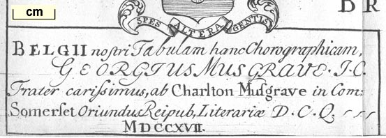
BELGII nostri Tabulam hanc Chorographicam, GEORGIUS MUSGRAVE J.C. Frater carrissimus, ab Charlton Musgrave in Com: Somerset Oriandus Reipub. Literariae D.C.Q. MDCCXVII.translation:-
This chorographical map of our belgium is made by George Musgrave JC, dearest brother, of Charlton Musgrave in the county of Somerset, of the Literary Republic DCQ, 1717.JC is perhaps Jeseus College; DCQ unknown.
printed at the top is:-
TABULA BELGII BRITANNICI CHOROGRAPHICAor:-
Chorographical Map of British BelgiumThe word:-
BELGIUMis spread right across middle of the map.

SPES ALTERA GENTIStranslation like:-
The other hope of our raceThe blazon is probably:-
azure, 6 annulets 3,2,1 orfor the Musgraves. There is a small thistle upper left, the mark of difference for a sixth son.

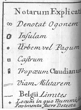
Notarum Explicat[io ]
[infinity sign?] Denotat Ogonem
[island with coast shaded] Insulam
[circle] Urbem vel Pagum
[square] Castrum
[tall rectangle, dark below, light above] Tropaeum Claudianum
[double line] Viam Militarem
[dotted line] Belgii Limites
[cross (+)] Locum inquo Nummi[ ] Pavimenta fuere Detectatranslating roughly:-
Explanation of notes: indicates an ogo ? ; island; town or village; fort or camp; Claudian monument; military road, boundary of 'Belgium'; place where coins or mosaic floors have been found.
labelled borders
up is N

OccidensThe map is printed with North at the top.
1 to 1400000
22.5 miles to 1 inchwith a large error.
sea plain
Trisanton Aestuar [= Southampton Water]
OCEANUS BRITANNICUS
[greek = Magnus Portus]
coast shaded
harbours

The islands and harbour areas at Portsmouth etc are fairly well drawn, enough to recognize each.

Itching flu
Avona fluThe Test and (perhaps) the Loddon are also shown in Hampshire.
BELGIUMThe bordering tribal areas are labelled, eg:-

ATREBATES [to the north, Gloucestershire and Berkshire?]
DUROTRIGES [to the South, Dorset]
DOBUNI [to the north west, partly Gloucestershire]
REGNUM [to the east, Sussex]
Venta Belgaru~

Clausentu~now distinguished from Southampton itself
Brigecrossing of Test, but location not now accepted.
Vindomisnow usually Calleva Atrebatum
Old Winchestershown as a camp
Regnum Vetus
roman roads

A netword of roman military roads is drawn by double lines. The routes shown in Hampshire are:-
from Calleva - Henley, Berkshire; through Vindomis - Silchester, Venta Belgarum - Winchester, Clausentum - Southampton, to Regnum Vetum - Ringwood, Hampshire.
branch from Venta Belgarum - Winchester, Hampshire; to Sorbiodunum - Salisbury, Wiltshire, whence south and west.
henges

Stonehenge


William Musgrave was born 4 November 1655 (perhaps 1657), son of Richard of Nettlecombe, Somerset, at Charlton Musgrove. He was educated at Winchester College and New College, Oxford, and became a physician and antiquary. He was elected Fellow of the Royal Society 1683-34, and was Secretary and editor of its Philosophical Transactions. He was elected a fellow of the Royal College of Physicians, 1692; in 1691 he had settled in Exeter, Devon, where he was in general practice. He married Philippa Speke of White Lackington, Somerset. And died 1721, being buried in a vault at St Leonard's Church, Exeter.
ANTIQUITATES BRITANNO-BELGAE, Praecipue Romanae, ... ... AUCTORE GUILH. MUSGRAVE, BELGA, Reg. Societ. utriusque Socio. ... ISCAE DUMNONORUM: Typis GEO. BISHOP: prostat [venale apud] JOH: MARCH, bibliopolam EXONIENSIEM; GUIL. TAYLOR, & JOH. [SPRINT, LONDINENSES.] M.DCC.XIX.
The Antiquities of the British Belgae, in particular Roman ... by Willm. Musgrave, Belgan, Fellow of both Royal Societies ... Exeter: George Bishop printer: sold by John March, bookseller, Exeter; William Taylor and John Sprint, London, 1719.


De Belgii nostri Limitibus.
BELGIUM nostrum ea pars Britanniae est, quae a Belgis, huc e Gallia demigrantibus, Superata, ab iis nomen adscivit, Limitesque longe lateque praetentos hunc in modum acceptit.
QUA ad Mare Britannicum patet, ab Occidente, Durotrigum Promontorio, in Purbeck Insula, terminabatur; ab Oriente, Portu, qui a Ptolemaeo [greek = Magnus Portus] appelatur: Hae Extremitates quadraginta circiter Leucas a se invicem distant, & in eis Promontoria sinum faciunt, qui Vectim Ins. sibi Objectam habet, quam, velut ambabus ulnis, amplecti nititur.
AB hac ora, versus Septentrionem, & deinde procul Occidentum versus, Belgium exporrectum est; forma digiti Indicis, curvati; latitudinem habens summam quadraginta milliarium.
AD mare, ubi incipit, hinc Durotrigum terra; illinc, in oriente, Rhegno intercluditur. Paulo altius Segontiacis; tum, ad laevam, Atrebatiis, & eos proxime Dobunis, ad Fretum usque Sabrinianum, adjacet. Quod reliquum est, eius quasi dimidium, a meridie & occasu hic Durotriges, illic Dunmonios a Septentrione Fretum isthoc interjacet.
HOSCE Belgarum Limites, ut, quam possim, accurate persequar, a Durotrigibus eos separavit, ita mihi videtur, Avona fl. ex adverso Vecti Ins. Promontorio, se in mare Britannicum exonerans. Neque enim [footnote Vide Atlantis Geograph. N. I.] Tabulis Britanniae Romanae, Camdeno, vernacula lingua edito, annexis, aliique recentiori, quae Belgium ultra Alaunum in occidentum extendi facit, adhibere possum sidem; cum ita positi Nationium harum Limites, nullo probabili argumento fulciantur: e contrario, longe satius, & Antiquitati convenientius est, a Fluviis & Montibus, terminis scil. a Natura fixis, hos & huiusmode Limites statuere.
NEQUE uno isthoc nomine Belgium justo latius exhibitum: In eo Tabula porro corrigenda, quod Vindogladium, (Winborn) Durotrigum Urbem, contra Camdeni sententiam, ipsiusque rei probabilitatem, (est enim a mare non plus quatuor vel quinque milliaria) in Belgio locari faciat.
Concerning the boundaries of our Belgium.
Our Belgium is that part of Britain that was conquered by the Belgae who migrated hither from Gaul, and has taken its names from them; and usually is given boundaries that extend far and wide in the following way.
Insofar as it faces the British Sea, to the west it is bounded by the promontory of the Durotriges, in the Isle of Purbeck; to the east by the port which Ptolemy calls the Great Port. These extremes are about forty leagues apart, and the two promontories form a bay containing within it the Isle of Wight, which, as if enfolded by both arms. rests in its embrace.
From this shore northwards, and eventually far towards the west, stretches 'Belgium': in shape like a bent index finger; with a maximum breadth of forty miles.
From the sea where it begins, it is bounded at one point by the land of the Durotriges; then, to the east, by Regnum. A little higher it lies enclosed by the Segontiaci; then, to the left, by the Atrebates, and next to them the Dobuni as far as the estuary of the Severn. As for the rest, comprising about half of it [Belgium] lies, first to the south and west, between the Durotriges and the estuary, then northwards, between the estuary and the Dumnonii.
Tracing these bounds of the Belgae as accurately as I am able, it seems to me that they are separated from the Durotriges by the river Avon, which empties itself into the British Sea opposite the promontory of the Isle of Wight. Nor can I accept in the maps of Roman Britain appended to Camden in the vernacular tongue and in other more recent editions the positioning that makes Belgium extend westwards beyond the Alaunus; for by no sound argument can the bounds of these nations be positioned thus: on the contrary, it is far preferable and more in conformity with antiquity to establish these and similar boundaries by rivers and mountains - bounds fixed, indeed, by Nature.
Nor can a more extensive region justly be included under the single name 'Belgium': in this respect the map [with Camden ?1610 edn] needs further correction; that it causes Vindogladium, the city of the Durotriges, contrary to the opinion of Camden and all probability (for it is no more than five miles from the sea) to be located in 'Belgium'.


Prima Venerum repraesentat ...
Jovi inter varia eius cognomina (de quibus assatim Havrechus) nonnunquam 1. Ammonio datum est appellari: ...
Neptunem ostendit, eius Insignae Tridens ...
Sexta videtur esse Bacchi quid enim in sinistra Discus ille, nisi qui Horo Aegyptiorum Baccho, ... Dextera Poculum, vino forte plenum habet ...
Pallas haec omino est. ... Fortis, Strenua, Martialis ... dextera tenentem Hastam, sinistra Aegidem, capite Galeam: ...
Vastae haec Sacerdos, velata & stolata, ut Mysterium Religionis Sanctitatemque significet, dextra Pateram habet, qua se ad Sacrificia facienda paratum oftendat; sinistra Librum, ut opinor, Ritualem, veterum more, convolutum: ...
Ad Mercurio accedo; ...
1. Venus
2. perhaps Mars, the crest of his helmet mismade; in BM
3. Jupiter, with part of a thunderbolt; in BM
4. ? two serpents with rams heads twined round legs and arms, a ?raven on the head; in BM
5. Vulcan
6. Mercury, patera in left hand, purse in right hand; in BM
7. ? female, perhaps clasping a pregnant womb? in BM
8. Minerva; in BM
9. genius familiaris
10. Mars
11. ? holes for ?reins in hands
12. dog
13. ? holes for attributes in clenched hands; in BM
14. ?
15. three horned bull
16. ?
17. horse
18. Bacchus
19. steelyard weight, Venus


Boon, George C: 1972: Genius and Lar in Celtic Britain: Jahrbuch des Roemisch-Germanuschen Zentralmuseums (Mainz, Germany):: pp.265-269 and plates
Musgrave, William: 1719: Antiquitates Britanno-Belgae & Belgio Britannico, De (vol.1): (Exeter, Devon): vol.1: pp.123-152 and plates
Stukely, William: 1724: Itinerarium Curiosum::: p.137
Brailsford, J W: 1951: Guide to the Antiquities of Roman Britain: British Museum:: p.54 and plate 17; BM registration numbers 11.3-9 (which is 7 items?)
:: Wiltshire Archaeological Magazine: vol.1: p.214


