 Map Group NORDEN 1595


Speculum Britanniae ... a Mirror of Britain
Because evrye publique worke, is alwaies publiquely considered, and it is lawfull (I confesse) for alle men, to utter their opinions thererof freely as they finde it, and to call a fault a faulte. And because I cannot justifie all the Liniaments of so rude a body, I will saye with him that findes the fault (though in Art he cannot mend the same) Sir it is a fault and I will mend it if I can: But I have not yet seene the worke of the most absolute artist so perfect.


strapwork cartouche
map maker
publisher

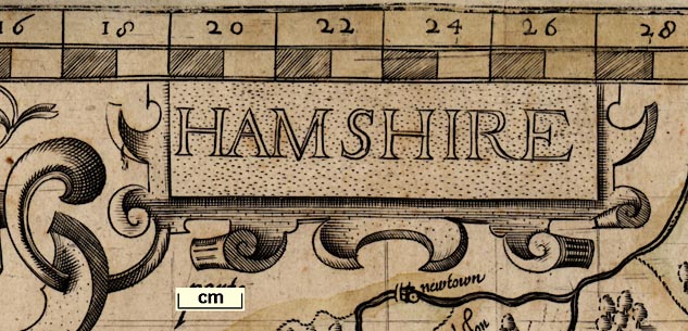
Printed upper left of centre in a strapwork cartouche is:-
HAMSHIREPrinted lower right in a strapwork cartouche is:-
Johes Norden descripsit - Printed and sold by John Overton at ye white horse without NewgateThere three different hands in the engraving; the first three words are [presumably] original, the next four and ' ye white horse' were [presumably] an amendment by Peter Stent who printed the map in the 1650s-60s, the rest is John Overton's. Similar alterations to engraving can be spotted in other parts of the map.
HONI SOIT QUI MAL Y PENCE
DIEU ET MON DROITMiddle left is a personal coat of arms in a strapwork cartouche crest a helm surmounted by a globe, and motto:-

OPERA MUNDIThese are the arms of William Sanderson, a friend of Norden, and:-
a wealthy merchant and well-known patron of geographical undertakingsOn the right above centre is the arms of:-
John Pawlet Marquis of Winchester Ano~. 1551. by K: Edwardin the engraving of this are colour letters s - sable for the ground, and a - argent for the swords. The arms has a tiny crescent, a mark of cadency?
On the right below centre is the arms of:-
Thomas Wriotheosley created Earle of Southampton An~o. 1551 by K: Ed: 6t.which also has colour letters to guide a map colourist.
compass rose
up is N
dividers

Printed in the sea area south of Hayling is a compass rose with broad star points for the cardinal, half cardinal, false and by points. The cardinal directions are labelled:-
Septen / or / merid / ocfor septentriones - north, oriens - east, meridiens - south, occidens - west. The compass is suspended from a ring held by a cherub who has a pair of compasses in its other hand. The map is orientated with up being north.
scale line
index grid
old english mile
The scale of miles goeth rounde about the Mapp

All four map borders are chequered to show miles, west-east and north-south; the origin of the scales is top left. Each two miles is labelled across top and bottom, 2, 4, 6, ... 48. The labelling on the sides runs down a, b, c, ... x (no 'i' or 'u'). Besides being scale lines the scales and the grid printed across the map in fine lines make an index grid. John Norden's provision of an index grid is an innovation in map making.
Calculations have been made to overlay the National Grid system on the map. For details, and how this grid can be used compare early county maps, and to index places, see:-

bottom left SY885867
top left SU024823
top right TQ041676
bottom right SZ902720
48 miles = 400.5 mmWrongly assuming a modern statute miles this gives a scale 1 to 192880; the map scale is about:-
1 to 190000
3 miles to 1 inchA better estimate of scale has been estimated from the positions of towns, also providing a value of the 'old english mile' used in Norden in 1595. The process is described in notes DISTTAB.rul accompanying software which does the sums. The map scale is about 1 to 241379, say:-
1 to 240000
4 miles to 1 inchNorden uses an:-
Old English Mile = 1.24 statute miles

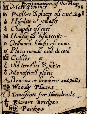
Explanation of the MapThis is an untidy tabulation of
symbol / text explanation / count of instances
[dot and circle, two towers, ?weathercock] / Market townes / 18
[dot and circle, tower] / Parishes & places of cure / 248
[dot and circle, upright line] / Hamlets et villages /
[dot and circle, upright line and half bar] / Chappells of ease /
[dot and circle, two towers] / Howses of besterecite /
[dot and circle] / Howses of name /
[dot and circle, crossed out by a slash] / Places ruinate and decaid /
[dot and circle, two towers, flag] / Castles / 5
[dotted circle, flag] / old trenches & fortes /
[dot and circle, cross] / Monasticall places /
[hillock, three posts] / Beacons or beaukens and Hills /
[trees] / Woody places /
[dotted line] Devision for Hundreds /
[wiggly lines, double line] / Rivers Bridges /
[dotted ring, trees] / Parkes /The formal declaration of his conventional signs is an innovation in english mapmaking introduced by Norden, though used earlier in Europe. Looking closely the heading, the count numbers, and all the engraving from 'and Hill' onwards are added to what was a neater table. It is possible to see the end of the original table's cartouche. The amendments are on the earlier, Stent, state of the map, unchanged by Overton.
sea moire effect
sea monsters
ships

PARTE OF YE BRITISH SEA

Off Hurst there is a large fishes's head and about Spithead can be seen the ghostly remains of an erased engraving of a galleon, perhaps making space for the sea area label.
coast shaded
harbours
headlands

The coast line is emphasised by shading. Foreshore areas of mudflats or shingle are shown pecked, and

THE MACKETTis labelled off Hayling. Only:-
Titchfeilde ha
Hamble haare explicitly labelled as harbours, and:-
black cliffe
Hengistbury headas coastal features.
castles
fortifications

hurst castle
calshott cast
St. Androws cast
south castleand also, marked as a ruin:-
Ruynes of hasel worth castle

Artillery style fortifications are clearly drawn around Portsmouth.
lakes
bridges

Rivers are drawn by broad wiggly lines tapering inland. Ateam might have a pond at its head, an echo of a medieval convention? The lower parts might be shaded and have stream or form lines, for example in the Itchen. Braiding might be shown. Rivers are not named. The braiding of the stream near Cove in the north east of the county:-

is probably Eelmoor Marsh
Some bridges are drawn, by a double line arched over the stream, for example at Ringwood:-

and at Fordingbridge on the Avon, and Newtown on the Enborne.
Some lakes and ponds are shown, for example at Highclere and Fleet.
hillocks

Butser hill
toothill

Beacons are drawn by posts, generally three - small large small, on a hillock. A few are labelled; all can be recognised:-
Burghclere, S of village
Popham, SW of village, labelled:-
3 patow beacons
Farleigh, SW of village
Farley, W of Pitt
Toothill, N of Chilworth, labelled:-
toothill Beacon
Botley, W of village
Titchfield, W of village
Selborne, SW of Brockenhurst, labelled:-
Selborn bea[c]
Hyth, W of village
Malwood, perhaps
Exton, NW of village
Crondall, S of Cove. 2 hillocks each with 3 posts
Portsdown, N of Cosham
forests
trees

BUCK HOLT FORRESTE
Wutmer FOrrest
FOREST OF EAST BEARE
Weste beare forrestThe placement of the labels demonstrates the difficulties of that map making task. If you didn't know that there is a West Bere Forest you might never have associated the detached letters scattered between 'sparshott', 'wecke', 'pitt' and hillock and tree symbols:-

A single tree on a hillock is labelled:-

lomerashNW of Exton.

rotherfeilde
parke
pkeTrees are placed in parks with some thought, not just decoratively:-

fremantle pk

The county boundary is a dotted line. Adjoining counties are labelled, eg:-
parte of Wiltshire
PARTE of SusSEXwith a mixture of swash and plainer mixed case lettering. The detached:-
part of hamshirefrom Ambersham to Fernden, is drawn and labelled.
table of hundreds

Printed in a strapwork cartouche upper left is a table:-
HUNDREDES In hamshire 40The count number is added. The table lists the hundreds against a key number, eg:-
1 Crundall hundred
2 Odiam
3 Alton
...The numbers are marked in areas on the map. The hundred boundaries are dotted lines.
town walls
town gates

Winchester

lymington
Southampton
Odyam

quareley
Exton

blackwater
hyth

stanbridgeA house of best reception:-

wintneyand a rather more magnificent example, the house of an important courtier:-

basing

And monasticall places:-

somerford

beaulieu
water mills
windmills

A fine post mill is drawn on a hillock W of Chalton.

A circle with paddles is drawn in the Bourne Rivulet between Hurstbourne and St Mary Bourne.
Allom chine copperas house
bascambe copperas house
hillforts

'old trenches and fortes' are marked on the map. For example the hillforts at Burghclere, by the beacon, and at Butser.
Silchester and Danebury have the symbols for 'places ruinate and decaid'.

the ruins of Haselworth Castle; the circle with a flag is crossed out.


It is worth reading John Norden's place names on this map very carefully. We believe that this map is the one copied by several succeeding map makers who misread the engraved names in ways that can be clearly understood from careful inspection of the letter shapes used here.
durleyis a clear example, the tail of the y curling up and reaching to the dot and circle.
There appears to be a pattern of using a single label for more than one symbol, two or even three. Eg:-
hursley- labels a parish ie village, and a park with its house. And, eg:-
warneforde- labels a parish ie village, a house of best reception, and a ruined and decayed place. This is more complicated in that we believe the house to be the ruin, two symbols for one entity. Only occasionally are symbols completely isolated from an obvious label, for example, an ordinary house south of Idsworth has no label.
[dot and circle, tower] / Parishes & places of cure
A house of best reception symbol can often be matched to a great house, not necessarily still standing. But how much is the place just a house, and how much does the symbol also represent a settlement of dependent dwellings round about? This is even more likely to be the case with an ordinary house, the place marked is a hamlet.
It is up to the user to decide on these questions. We have matched the settlements on the map to known settlements as well as we can in Gazetteer for Norden 1595, indexed by placename or by hundred, in:-


See British Museum Add MSS 31.853 ff.23v-24.
This has only the maps and descriptions for Essex and Hampshire, the latter has the islands as well, other material is lost.


The map was engraved by Christopher Schwytzer and possibly published around 1600, but no copy survives?
Published by Peter Stent, at The White Horse, Guiltspur Street, London, about 1650s-60s.
Published by John Overton, London, atlases 'I', 'II', 'III' and 'V', about 1670, 1675, 1690, and 1700.


