 Map Group PERROT 1823


These notes are made from the copy in the Map Collection of Hampshire CC Museums Service, item HMCMS:FA1999.107.


map maker
engraver

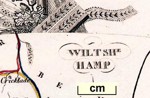
WILTSHE / HAMPAt the bottom of the map is:-
Le plan par Thierryand at the bottom of the sheet:-
A. M. Perrot 1823
Me Migneret Sc.The engraving was by Migneret; the map derived from a map by Thierry; and designed? or published? by Perrot.

The map is engraved as if it were a sheet hanging on poles. The poles are on the shaft of an anchor, the flukes showing below. This and ropes must symbolize Portsmouth and Hamsphire's maritime importance. There is also a boar's head, a 'Hampshire Hog'? Above there are wheat ears and oak leaves. Hampshire is renowned for a good cereal crops and oak forests. This doesn't leave much for Wiltshire!
1 to 2900000
45.5 miles to 1 inch
coast form lines

The coast is drawn with a bold line and form lines extending out into the sea area. On this very small map only Southampton Water shows clearly, Portsmouth and Langstone harbours are shown inaccurately.

Anton R. [River Test]
River Stour
Avon R.
Lymington River
River Itchin
River Meon
River Wey (northern)

The county boundary is a dotted line. The two counties are labelled:-
WILT
HAMPand adjoining counties are labelled in a similar abbreviated style. Each county has a tint on the inner side of its boundary: Wiltshire yellow, Hampshire red; and around them, Dorset brown, Somerset blue, Gloucestrshire red, Berkshire blue, Surrey brown, and Sussex brown.

Winchester

Alton
Andover
Basingstoke
Christchurch
Farnham [ie Fareham]
Gosport
Havant
Lymington
Odiham
Petersfield
Portsmouth
Ringwood
Romsey
Southampton
Stockbridge


Published in 'L'ANGLETERRE, OU DESCRIPTION HISTORIQUE ET TOPOGRAPHIQUE DU ROYAUME-UNI DE LA GRANDE-BRETAGNE CONTENTANT Les comtes de la principaute de Galles, des royaumes d'Ecosse, d'Irelande at d'Angleterre, les iles Orcades, Shetland, etc. PAR M. G.-B. DEPPING, [ ] DE 75 CARTES ET VUES. TOME 1. A PARIS CHEZ ETIENNE LEDOUX, LIBRAIRE, RUE GUENEGAUD, No 9. 1824.'


