Research Notes


Map Group PHILIP 1886

Philip 1886
Map, Hampshire, scale about 8.5 miles to 1 inch, by George Philip and Son, 32 Fleet Street, London, and Caxton Buildings, 1886; published in earlier states from 1872; published in various states to 1890s-1900s.
These notes are taken from the map of Hampshire in Philips' Handy Atlas of the Counties of England, published by George Philip and Son, London and Liverpool, Lancashire, new edition, 1886. The map studied, and the atlas, are in a private collection.
The colour printed map of Hampshire is plate 14, a folded sheet pasted to a guard strip bound in the atlas.
The map size is:- wxh, sheet 18.5x22.5cm double page; wxh, map = 153x203mm.
 
MAP FEATURES
RAILWAYS
THE ATLAS
ITEMS in the Collection

MAP FEATURES
title    
Printed upper left is:-
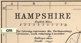
HAMPSHIRE

map maker    
Printed at the bottom is:-
GEORGE PHILIP & SON, LONDON & LIVERPOOL.

orientation    
up is N    

The map has no compass rose; it is printed with north at the top of the page as it is meant to be read. For Hampshire this is sideways, other maps are printed the other way on the double page spread, suiting their shape to the space.

lat and long scales    
lat and long grid    
index grid    

There is a rectangular latitude and longitude grid, a graticule, printed over the map, at 10 minute intervals, labelled in the borders at 30 minute intervals. The longitude of Winchester is 1 degree 18 1/2 minutes W corresponding to a prime meridian at Greenwich (accepted internationally 1884).
The map covers 0 degree 45 minutes to 1 degree 55 minutes W, 50 degrees 30 minutes to 51 degrees 30 minutes N; Hampshire including the Christchurch area, now Dorset, and the Isle of Wight.
The graticule also serves as an index grid. The 10x10 minute cells are labelled in the borders A..H top to bottom, 1..6 left to right. These are referred to by the:-
INDEX
at the back of the atlas, where:-
NOTE,- The letters and numbers after the names correspond with those in the borders of the map, and indicate the square in which the name will be found.
For example:-
Winchester, Hampshire ... D 3
in which square you will find the word though the town symbol is in E3.

scale line    
scale    

Printed upper left under the title is a scale line of:-
English Miles
marked at 1 mile intervals. The 10 miles = 29.7 mm giving a scale 1 to 541867; the map scale is about:-
1 to 540000
8.5 miles to 1 inch

table of symbols    
There is a limited table of symbols printed under the title.
The Coloring [sic] represents the Parliamentary Divisions, each returning 1 Member.
Railways [bold line and cross line for] Sta.
Roads [double line with single line branching off]
Canals [curving line]

sea area    
sea tinted    

The sea is colour printed blue; some sea areas are labelled, eg:-
Southampton Water
The Solent
ENGLISH CHANNEL

coast line    
harbours    
headlands    

The coast line is emphasised with pale orange.
Only the two large harbour areas are noticed:-
Portsmouth Harbour
Langston Harbour
A couple of headlands are labelled:-
Gilkicker Pt.
Hengistbury Head

coastal defence    
castles    
fortifications    

A few of the coastal defence castles are noticed by the map makers, labelled:-
Hurst Castle
Calshot Cas.
Ft. Monckton
Cumberland Ft.
But there are no fortifications around Portsmouth or Gosport.

rivers    
Rivers are shown by wiggly lines and might be labelled, eg:-
Lymington R.
R. Test
All the major river systems of the county are shown and labelled, with some tributaries.

relief    
hill hachuring    

There is a little hill hachuring to indicate relief, and some labelling, eg:-
NORTH DOWNS
Knap Hill
Mt. Pleasant

county    
The county boundary is a dotted line, tinted orange. Adjoining counties are labelled, eg:-
BERKSHIRE
Roads and some towns are marked outside the county for continuity.

electoral data    
The electoral divisions of the county are bounded by dotted lines, with an orange tint. The six areas are palely coloured: N - yellow; E - green; W - pink; S - violet; New Forest - yellow. The areas are labelled with their name, eg:-
N. OR BASINGSTOKE
At the front of the atlas are various lists of electoral data:-
A LIST OF THE PARLIAMENTARY BOROUGHS.
showing the number of members returned to Parliament.
...
Christchurch ... 1
Portsmouth ... 1
Southampton ... 2
Winchester ... 1
and:-
LIST OF THE COUNTY DIVISIONS, According to the Redistribution Bill, 1885, each Division returning 1 Member.
...
HAMPSHIRE -
N. or Basingstoke
E. or Petersfield
W. or Andover
S. or Fareham
New Forest
Isle of Wight
...

settlements    
Settlements are positioned by a circle which might be larger and shaded for bigger places. The size of place is also differentiated by the label text style.
city     large circle, shaded; labelled in upright bold block caps, eg:-
WINCHESTER
town     large or medium circle, shaded; labelled in bold italic block caps or bold upright lowercase, eg:-
PORTSMOUTH
Fareham
PORTSEA
Andover
village     circle; labelled in italic lowercase text, eg:-
Selborne
Wickham
hamlet     smaller circle; labelled in smaller italic lowercase text, eg:-
Kilmeston

roads    
A network of roads is drawn by double lines. There is no differentiation of the main roads, but there are some smaller roads drawn with a single line. Roads are continued out of the county to nearby towns and to the edge of the map.

miscellaneous    


beacons    
Beacons are hardly important by this late date, but some are indicated by labelling:-
Highclere Beacon [Burghclere]

antiquities    
hillforts    
roman roads    

A circle of slightly bolder hachures is used to mark some hillforts, labelled, eg:-
Deanbury Hill
Old Windmill Hill
Quarley Hill
There is one:-
Roman Road
shown from Winchester towards Kings Somborne.

hospitals    
The hospital at Netley is labelled:-
Hosp.
and also:-
Haslar Hosp.

army camps    
At Aldershot there are square areas labelled:-
North Camp
South Camp

canals    
The:-
Basingstoke Canal
is labelled against a wiggly line that doesn't taper like a river. The Salisbury Canal is, I think, drawn but not labelled.

  top of page

RAILWAYS
railways    
Railways are shown by a bold line, with a line across at stations; railways appear an important feature of the map. Some are labelled with the railway name, eg:-
London & South Western Raily.
and some are labelled outside the county with their destination, eg:-
From Trowbridge &c.
To London
The map includes:-
London and Southampton Railway - 1840
Bishopstoke to Gosport branch railway - 1842
Chichester to Portsmouth branch railway - 1847
Eastleigh to Salisbury branch railway - 1847
Southampton and Dorchester Railway - 1847
Berkshire and Hampshire Railway - 1848
Fareham to Cosham branch railway - 1848
Reading, Guildford and Reigate Railway - 1849
Farnham to Alton branch railway - 1852
Basingstoke and Salisbury Railway - 1857
Lymington Railway - 1858
Portsmouth Railway - 1859
Bishops Waltham Railway - 1863
Stokes Bay Railway - 1863
Petersfield Railway - 1864
Andover and Redbridge Railway - 1865
Mid Hants, Alton Lines, Railway - 1865
Salisbury and Dorset Junction Railway - 1866
Southampton and Netley Railway - 1866
Hayling Railway - 1867
Ringwood, Christchurch and Bournemouth Railway - 1870
Swindon, Grafton and Marlborough Railway - 1883
Didcot, Newbury and Southampton Railway - 1885
Hurstbourne to Fullerton branch railway - 1885
which is uptodate.

  top of page

THE ATLAS
The atlas was first produced as an item 1873. It probably first had the maps in this state 1885, and continued like this to 1891. Various later states were used up to about 1908.
The cover of the atlas red cloth embossed in gold with a picture of Britannia with spear and shield carrying the union flag, seated on a globe, title:-
PHILIPS' HANDY ATLAS OF THE COUNTIES OF ENGLAND NEW AND IMPROVED EDITION. 5/-
The title page:-
PHILIPS' HANDY ATLAS OF THE COUNTIES OF ENGLAND, INCLUDING MAPS OF NORTH & SOUTH WALES, THE CHANNEL ISLANDS, AND THE ISLE OF MAN. REDUCED FROM THE ORDNANCE SURVEY, AND COLOURED TO SHEW THE NEW PARLIAMENTARY DIVISIONS, ACCORDING TO THE REDISTRIBUTION BILL, 1885. NEW AND REVISED EDITION. WITH CONSULTING INDEX.
LONDON: GEORGE PHILIP & SON, 32 FLEET STREET. LIVERPOOL: CAXTON BUILDINGS, SOUTH JOHN STREET, AND 45 TO 51 SOUTH CASTLE STREET. 1886.
An advertisement facing the title page offers:-
HANDY VOLUMES FOR TOURISTS.
PHILIPS' HANDY ATLAS OF THE COUNTIES OF ENGLAND, A Series of Forty-three maps, showing the Physical Features, Towns, Villages, Railways, Roads, &c. ; with a Railway Map of England; forming a useful Guide for the Angler, Sportsman, or Tourist. New Edition, with Consulting Index. Crown 8vo, neatly bound in cloth, 5s.
...
And companion volumes for Scotland and Ireland.
The atlas size, overall, is wxh = 13.5x19cm.
The atlas has a title page, contents, lists of parliamentary boroughs and county divisions in each county, general map of England and Wales, separate county maps etc, and an index of place names. The atlas is 13x19cm; county maps are double sheets. Hampshire is plate 14.
The general map for the atlas is:-
RAILWAY MAP OF ENGLAND & WALES
This has a scale line 80 miles = 36.1 mm. The map scale is about:-
1 to 3600000
56 miles to 1 inch
The railways shown in Hampshire are not uptodate, but are probably reduced to keep the map uncluttered. You have to use the separate county maps for a reliable railway map.
  top of page

ITEMS  in HMCMS Map Collection and Private Collections   (scanned item in bold)
  private collection (5) -- atlas
  private collection (5_01) -- railway map
  private collection (5_14) -- map
  top of page

   All Old Hampshire Mapped Resources