|
Research Notes
 Map Group POTTS 1809
|
 |
|
Potts 1809
|


|
|
|
New Map of England and Wales, scale about 21 miles to 1 inch, AND a map of
Canals and Navigable Rivers in England and Wales, by Potts? about 1809;
published 1809-10.
|
| |
|
The two maps by Potts studied - his Map of England and Wales, 1809, and his Map of Canals, 1809 - are in the Map Collection, Hampshire CC Museums Service,
items HMCMS:FA2001.186.1 and HMCMS:FA2001.186.2. They appear to be from
the edition published by F C and J Rivington, London, 1810.
|
|
The map size is wxh, sheet = 45x57.5cm.
Remember that these notes are biased toward Hampshire
interest.
|
 |
MAP FEATURES - NEW MAP of ENGLAND AND WALES |
 |
HAMPSHIRE TOWNS - NEW MAP of ENGLAND AND WALES |
 |
MAP FEATURES - MAP of CANALS in ENGLAND AND WALES |
 |
PUBLISHING HISTORY |
 |
REFERENCES |
 |
ITEMS in the Collection |

| top of page |
 |
|
| MAP FEATURES |
- NEW MAP of ENGLAND AND WALES |
title
map maker
publisher
|
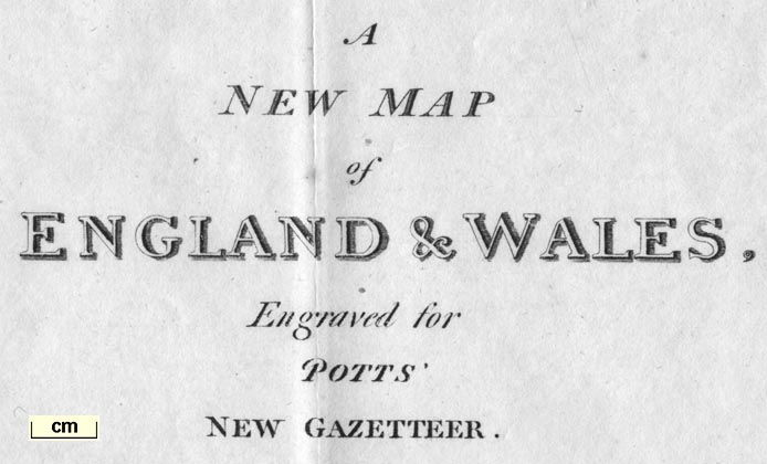
Printed upper right is:-
A NEW MAP of ENGLAND & WALES, Engraved
for POTTS' NEW GAZETTEER.
Published Novr. 1st. 1809. for
Scatcherd and Letterman Ave Maria Lane. and the other
proprietors.
This is one of two maps in the gazetteer; the other map shows
canals and navigable rivers.
|
table of symbols
|
There is a minimal table of symbols printed below the title,
upper right:-
EXPLANATION
Roads ... [double line]
Rivers ... [wiggly line]
Boundaries of Counties ... [dotted
line]
|
scale
scale line
|
Printed lower right is a:-
Scale of Miles
The scale,line is chequered in miles labelled at 5 and 10,
then chequered and labelled at 10 mile intervals. The 70 miles =
86.0 mm giving a scale 1 to 1309931. The map scale is about:-
1 to 1300000
21 miles to 1 inch
|
orientation
up is N
|
The map is printed with North at the top of the page. There is
no compass rose or other indicator.
|
lat and long scales
|
Printed in the map borders are scales of latitude and
longitude; chequered at 10 minute intervals, labelled at degrees.
Although the divisions looked slanted on top and bottom scales
the projection seems to be rectangular. The map includes from 1d
40m E to 5d 40m W, from 45d 55m to 55d 55m N; England and Wales,
an outline of Scotland up to Edinburgh, and the edges of Ireland
and France.
The prime meridian is a little east of London, but perhaps no
at Greenwich. The approximate:-
longitude, Winchester = 1d 12m W
which conforms to this estimate.
|
sea area
sea plain
|
The sea is plain; some sea areas are labelled, eg:-
ENGLISH CHANNEL
Southampton W.
Spithead
|
coast line
coast shaded
headlands
|
The coast line is shaded for emphasis.
Along the coast headlands might be labelled. While Portsmouth
Harbour can be recognised it and other harbours are not
labelled.
|
rivers
|
Rivers are drawn by wiggly lines tapering inland. The major
river of Hampshire are mostly included with some tributaries.
Looking closely they are not as accurate as they might be. For
instance: the Test has the Wallop and Dever tributaries, and is
shown coming down from the St Mary Bourne direction, ie what is
now called the Bourne Rivulet; the Test through Whitchurch etc is
missing. The Wallington River is missed. The Loddon system looks
less 'complete' than it might be. The treatment of the Meon at
its mouth has two sizeable estuaries side by side. Unusually, the
Bourne that crosses the NW corner of the county is shown. Some
rivers are labelled, for Hampshire:-
Stour R.
R. Avon
R. Bourne
Wey R.
|
relief
|
No relief is shown.
|
county
|
County boundaries are fine dotted lines. The county areas are
labelled, often by an abbreviation, eg:-
HANTS
The detached part of Hampshire in Sussex is drawn, but
wrongly. Part of its boundary is missed and it appears as an
extension of Surrey. Another detached piece, on the north border
of Hampshire, is labelled:-
P. of Wilts
|
settlements
|
Settlements, cities and towns, are located by a circle or dot
and double circle, differentiated by the mark and by style of
lettering. Only larger places are shown.
|
|
city
|
bold dot and double circle; labelled in upright block caps,
eg:_
WINCHESTER
|
|
|
|
town
|
circle; labelled in italic lowercase text, eg:-
Southampton
Alton
|
roads
|
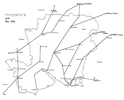
A network of roads is drawn by double lines. The network does
not include all the older established routes, does include some
of the newer roads, and has some unexpected gaps. Only a diagram
can demonstrate this.
|
| Route diagram:- |

|

| top of page |
 |
|
| HAMPSHIRE |
TOWNS - NEW MAP of ENGLAND AND WALES |
|
In Hampshire the map shows the expected 21 places:-
|
|
Alton
|
|
Andover
|
|
Basingstoke
|
|
Bishops Waltham
|
|
Christ Church
|
|
Fareham
|
|
Fordingbridge
|
|
Gosport
|
|
Havant
|
|
Kingsclere
|
|
Lymington
|
|
New Alresford
|
|
Odiham
|
|
Petersfield
|
|
Portsmouth
|
|
Ringwood
|
|
Romsey
|
|
Southampton
|
|
Stockbridge
|
|
Whitchurch
|
|
WINCHESTER
|

| top of page |
 |
|
| MAP FEATURES |
- MAP of CANALS in ENGLAND AND WALES
|
|
The basic features of the map are very like those of its
companion map in the gazetteer, a New Map of England and
Wales.
|
title
map maker
publisher
|
Printed upper right is:-
CANALS and NAVIGABLE RIVERS in ENGLAND
AND WALES, Engraved for POTTS' NEW GAZETTEER.
Published Novr. 1st. 1809. for
Scatcherd and Letterman Ave Maria Lane. and the other
proprietors.
|
table of symbols
|
Printed below the title, upper right, is a table of symbols
particular for this map:-
EXPLANATION
Canals ... [wiggly lin]
Rivers which are only described as far
as they are navigable ... [double line]
|
rivers
|
Rivers are shown by a double wiggly line if they are
navigable. In practice the tapering line becomes a single line.
Most are labelled, eg:-
Itching R.
|
|
canals
|
Canals are shown by a bold wiggly line, labelled, eg:-
Andover C.
|
|
HAMPSHIRE WATERWAYS
|
|

|
|
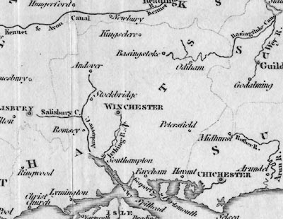
The navigable waterways shown in Hampshire are:-
|
Basingstoke Canal
|
Basingstoke Can.
Drawn with its bendy contour route east from Basingstoke,
passing near Odiham, looping to the north, ... joining the Wey
just before it reaches the Thames, whence London.
The branch to Stratfield Turgis is shown; though it was never
cut.
|
Andover Canal
|
Andover C.
Drawn south from Andover, passing by Stockbridge, to
Southampton Water at Redbridge.
|
Salisbury Canal
|
Salisbury C.
Drawn due east from Salisbury to join the Andover Canal. This
canal was never finished.
|
Itchen Navigation
|
Itching R.
Shown as navigable from Southampton Water, by Southampton, to
Winchester, with a couple of 'cuts'.
|

| top of page |
 |
|
| PUBLISHING |
HISTORY |
|
Published in Potts' New Gazetteer, by Scatcherd and Letterman, Ave
Maria Lane, London, 1809. |
|
Published in a ?second edition 'GAZETTEER OF ENGLAND AND WALES:
CONTAINING THE STATISTICS, AGRICULTURE, AND MINERALOGY, OF THE COUNTIES; THE
HISTORY, ANTIQUITIES, CURIOSITIES, MANUFACTURES, TRADE, COMMERCE, FAIRS,
MARKETS, CHARITABLE AND OTHER INSTITUTIONS, POPULATION, AND ELECTIVE FRANCHISES,
OF THE CITIES, TOWNS, AND BOROUGHS; INCLUDING A COMPLETE INDEX VILLARIS, WITH
THE BEARINGS AND DISTANCE OF EACH VILLAGE AND MANSION FROM THE NEAREST MARKET
TOWN. ILLUSTRATED BY TWO LARGE MAPS, DESCRIPTIVE OF THE ROADS, AND INLAND
NAVIGATION. BY THOMAS POTTS. / London: PRINTED FOR F. C. AND J. RIVINGTON; ...
1810.' |

| top of page |
 |
|
| REFERENCES |
|
|
|
: 1809: Potts' New Gazetteer: Scatcherd and Letterman (London) |
|
: 1810 (2nd edn): Potts' New Gazetteer: Rivington, F C and J (London) |
 |
|
|
ITEMS |
in HMCMS Map Collection (scanned item in bold)
|

|
HMCMS:FA2001.186 -- book
|

|
HMCMS:FA2001.186.1 -- map
|

|
HMCMS:FA2001.186.2 -- map
|

| top of page |
|
 |
All Old Hampshire Mapped Resources |

 Map Group POTTS 1809


