|
Research Notes
 Map Group SHERINGHAM 1840s-50s
|
 |
|
Sheringham 1840s-50s
|
|
|
|
Chart, England South Coast, Dunnose to The Needles, and the Owers to Dunnose
including Spithead, etc, scale roughly 1 inch to 1 mile, surveyed by Captain Sheringham, published by the Hydrographic Office, Admiralty, 1848.
|
|
The chart studied is in the Map Collection of Hampshire CC Museums Service,
item HMCMS:FA1992.1.1.
|
|
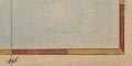
The chart is a hand coloured engraving. The chart size is:
wxh, sheet = 96.5x65cm, trimmed at bottom; wxh, map = 947x640mm?
Note that these notes will be biased towards a Hampshire
interest; parts of Sussex and the Isle of Wight might be
ignored.
|
| |
 |
MAP FEATURES - basics, sea and coastal features, rivers, salterns |
|
|
MAP FEATURES - inland features |
|
|
ADMIRALTY SURVEYING INSTRUCTIONS, 1851 |
|
|
REFERENCES |
|
|
ITEMS in the Collection |
|
|
|
CAPTAIN SHERINGHAM
|
|
Willaim Louis Sheringham joined the Royal Navy as a
Midshipman, 13 June 1808. Whilst he was on the books of the Royal
George, Ocean and Howe, flagships at the Nore, 1830-36, he
assisted Captain Francis Beaufort, Hydrogapher at the Admiralty,
in the compilation of sailing directions and the re-organistaion
of the hydrography department.
|
|
From 1837 he was in charge of the survey of coasts of Wales.
In 1839 the survey turned to Cornwall, but in 1841 jumped to the
Portsmouth area at which point Lieutenant Sheringham was made
Commander. 9 October 1847 he was made Post Captain, continuing to
be surveyor in charge on the south coast of England. In the
period following the Owers to Christchurch chart was made.
|
|
Captain Sheringham continued in hydrographic surveying to
1853. After this date he was a captain on the Fisgard at
Woolwich.
|
|
Dawson, L S, Commander: 1885:
Memoirs of Hydrography: Keay, Henry W (Imperial Library,
Eastbourne, Sussex): part 2
|

| top of page |
|
|
| MAP FEATURES |
- basics, sea and coastal features |
title
map maker
publisher
|
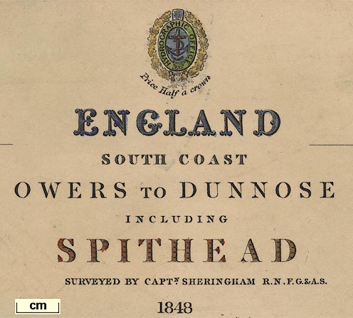
Printed upper right is the insignia of the Hydrographic Office
of the Admiralty; a foul anchor in an oval with the legend:-
HYDROGRAPHIC OFFICE
surrounded by a wreath of oak leaves. Below which:-
Price Half a crown
and the title of the chart:-

ENGLAND SOUTH COAST
OWERS TO DUNNOSE INCLUDING SPITHEAD
SURVEYED BY CAPTN. SHERINGHAM R.N. F.G.&A.S. 1848
|
table of symbols
tides
|
Below the title is an explanation of some of the symbols, and
other data.
Portsmouth Observatory 50 [degrees] 48
[minutes] 0 [seconds] N. 1. 6. 12. W.
[dotted line, plus pecked shading and
blue tint] 1
[dot dot space line, plus pecked
shading and blue tint] 2
Fathoms lines
[3 dots space line, plus pecked shading
and blue tint] 3
[5 dots space line, plus pecked shading
and blue tint] 5
High Water at Portsmouth Dk. Yd. XIh.
40m. Spring Tides rise 14 feet, Neap 6 1/2.
and tide data for Cowes, Bembridge Point, and Selsea Bill.
There is a list of abbreviations:-
B. Bay, C. Cape, C.G. Coast Guard, Hd.
Head, Hr. Harbour, I. Island, P. Port, Pt. Point, R. River, Rk.
Rock.
cl. clay, crl. coral, gr. gravel, m.
mud, r. rock, s. sand, sh. shells, st. stones.
Figures underlined shew the depth at
H.W. in Feet.
Figures on the land shew the height in
feet above H. Water.
Bearings to the Marks and Views are
Magnetic.
SOUNDINGS IN FATHOMS
|
orientation
compass rose
up is N
magnetic variation
|
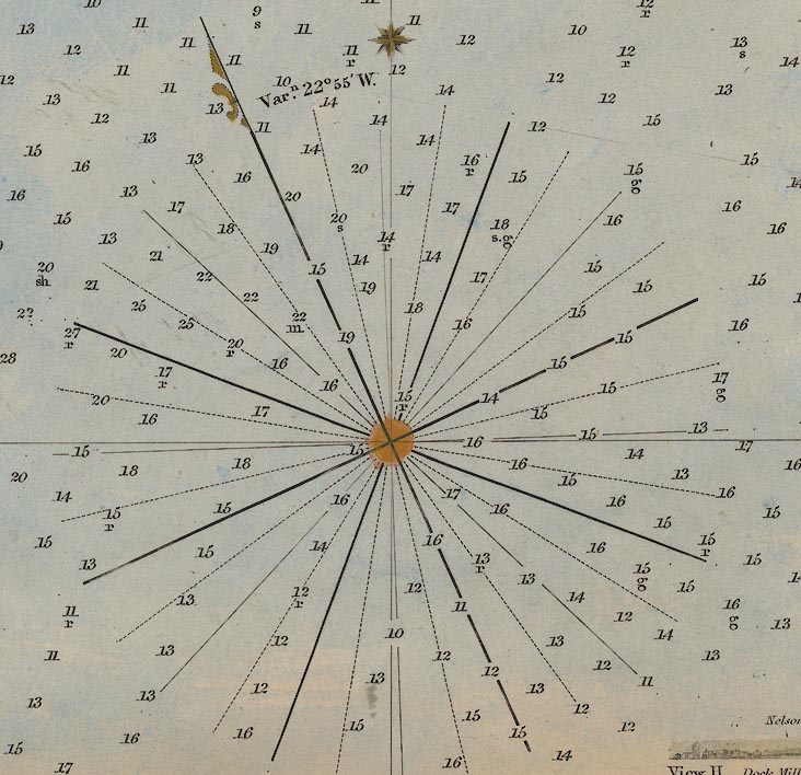
Printed lower left of centre and lower right are compass roses
showing magnetic directions; no circle, bold lines for cardinal
and half cardinal directions, lines for false points, dotted
lines for by points, magnetic North marked by a half fleur de
lys. The meridian through the rose is marked with a star, and the
angle between the meridian and magnetic north labelled:-
Varn. 22 [degrees] 55 [minutes]
W.
at 1d 5m W, and:-
Varn. 22 [degrees] 40 [minutes]
W.
at 0d 40m W.
The chart is printed with [geographical] North at the top of
the sheet. The centre of the rose, the fleur de lys, and the star
are tinted orange.
|
scale
|
The chart has no scale line. The scale may be estimated from
the scale of latitude; 15 mins = 529.5 mm gives a scale 1 to
52558. The chart scale is about:-
1 to 53000
1.2 statute miles to 1 inch
|
lat and long scales
lat and long grid
|
Printed in the chart borders are scales of latitude and
longitude for a rectangular projection; chequered at 1 minute
intervals, tinted red and yellow, labelled at 5 minute intervals.
The bottom scale is labelled:-
West from Greenwich
A graticule is printed across the chart at 5 minute intervals.
The map includes from 0d 38m to 1d 20m W, from 50d 33m to 50d 51m
N: part of the coast of West Sussex, from Bognor to the Hants
border, showing The Owers; part of the coast of Hampshire from
Sussex to Southampton Water, including Spithead; the east half of
the Isle of Wight from Cowes round to St Catherine Point.
|
sea tinted
depth soundings
depth contours
sandbanks
buoys
anchorages
|

The sea area is layer coloured in pale blue tints. There are
depth contours, as explained in the table of symbols. The system
of tints for each interval of depth is confusing to the eye; its
understanding not helped by colours being rubbed and/or faded,
and not completely evenly applied in the first place. Paleness is
not proportional to depth. Calling the tints, all are pale,
'blue', 'pale blue', 'palest blue', then:-
0 to 1 fathom is blue
1 to 2 fathoms is pale blue
2 to 3 fathoms is palest blue
3 to 5 fathoms is pale blue
5 to 10 fathoms is palest blue
deeper than 10 fathoms is pale blue
The depth contour is dotted to correspond to the depth,
eg:-
The five fathom contour has groups of 5 dots. The deep contour
is a dot dash line.
Depth soundings cover the whole sea area and are continued
into harbour channels and river estuaries. Depths are in fathoms
and, above 5 fathoms, are given to a 1/4 fathom. Soundings are
made on a rectangular grid orientated NE-SW by NW-SE, at roughly
quart mile intervals. How do you position a ship accurately in
the sea to do this, in 1848? The depth of water changing with the
tide, position dependant on tidal flow ...
The nature of the bottom might be given by a small letter,
eg:-
g.sh.
for gravel and shells.
Some sea areas are labelled, eg:-
SPITHEAD
Stoke Bay
Hayling Bay
SOUTHAMPTON WATER
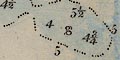
Many sandbanks and shallows are labelled, eg:-
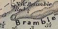
Bramble
HORSE SAND
Horse tail
LANGSTON BAR
Hayling Knob
Buoys are drawn as a ?conical buoy, point down (not e modern
conical buoy). Many are named, and labelled with a letter for
?colour. For example, along the Horse and Dean Sands, from
seaward, are:-
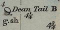
Dean Tail B
Dean Elbow B
Dean B
Horse Elbow B
Horse B
to be kept to starboard when entering harbour. The wreck of
HMS Boyne which caught fire, blew up and sank is marked by a
buoy:-
Boyne W
A small ship:-
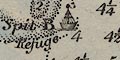
Spit B Refuge
Is shown at the end of Spit Sand. The buoy NE of the Bramble
is drawn chequered, and labelled:-
N.E. Bramble Cheq
One anchorage is marked by an anchor symbol in St Helens
Road.
|
coast line
coast tinted
headlands
harbours
lighthouses
sea marks
leading lines
coast view
coastguards
|
The coast line is drawn with some pecked shading to landward,
and tinted pale brown. The land behind is tinted pale green. The
foreshore is dotted and tinted, and might have letters indicating
its nature, eg:-
cl
for clay. Some foreshore areas are labelled, eg:-
Hamilton Bk.
East Winner
Headlands are labelled, eg:-
Lee point
Gilkicker Pt.
Harbours are clearly drawn with channels with depth soundings,
etc. Eg:-
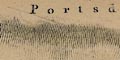
PORTSMOUTH HARBOUR
Hill Head Haven
The River Hamble has a series of posts marking the
channel.
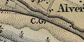
Along the coast there are letters:-
C.G.
where there are coast guard stations.
Topography inland is noticed only for a short way from the
shore, but includes features for their usefulness as sea marks -
windmills, monuments on the sky line, stark white chalk quarries,
etc. Some of these are used to define leading lines which are
drawn in the sea areas, eg:-
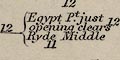
Egypt Pt. just opening clears Ryde
Middle
Kickergill in one with the Centre of
Fort Monkton N.N.W. leads up to Spithead
N. 1/2 E. Nelson's Monument in one with
E. end of trees on Portsmouth lines, leads E. of the Princessa
and warner, & W. of the Nab.
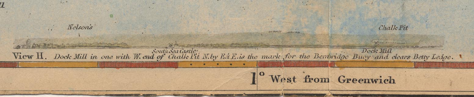
Dock Mill in one with W. end of large
Chalk pit. Mark for the Buoy. View H.
The last refers to a windmill, Dock Mill, east of Southsea
village, drawn by a post mill symbol, and the chalk pit on
Portsdown. This leading line marks the buoy 'Bembridge Ledge
Black' off Bembridge Point, Isle of Wight. Coast view H is
printed at the bottom centre of the chart, labelled:-
|
|
View H. Dock Mill in one with W. end of
Chalk Pit. N. by E. 1/2 E. is the mark for the Bembridge Buoy and
clears Betty Ledge.
The view includes Nelson's Monument on Portsdown, Southsea
Castle and part of Portsmouth.
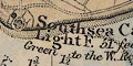
Lights are noticed along the coast, for example:-
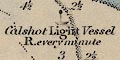
Calshot Light Vessel R. every
minute
drawn by a small ship, a black disk atop its mast. And marked
by a black disk within the castle area:-
Southsea Castle Light F. 51 feet Green
to the W. Red to the E.
Off the coast off the Isle of Wight, north of Ryde is a hilk
labelled:-
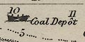
Coal Depot
And another labelled:-
Lazaretto
an isolation hospital to quaranteen seamen with infectious
diseases.
|
coastal defence
castles
fortifications
|
Coastal defences are noticed on the chart, both old castles
and newer fortifications, along with related navy features:-
Calshot Castle
Fort Monkton [artillery style
fortifications]
Haslar Hospital
Block House
[fortifications around
Gosport]
[fortifications around Priddy's Hard]
Magazine
[fortifications along north shore of
Portsea Island]
[fortification at Ports
Bridge]
Magazine [N of Tiphoe]
Magazine [S of Tiphoe]
[fortifications around RN
dockyard]
[fortifications around
Portsmouth]
Southsea Castle [artillery style
fortifications]
Lumps Ft.
Eastney Ft.
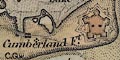
Cumberland Ft. [artillery style
fortifications]
|
rivers
bridges
ferries
|
Rivers are only noticed as channels in the foreshore or
estuaries. Some are labelled, eg:-
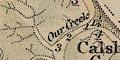
Our Creek
Titchfield River
Riv. Hamble
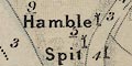
The River Hamble has a series of posts marking the
channel.
Ports Creek is clearly drawn,
unlabelled, the bridges of road and railway both shown. The long
bridge over the channel separating Hayling Island is
labelled:-
Hayling Bridge.
On the west tip of Hayling Island is a:-
Ferry
|
salterns
|
On the west bank of the River Hamble is:-
Salt Pans
and on the east:-
Old salt House
On Portsea Island there are:-
Salterns
by Salterns Farm on the east shore. On Hayling Island's east
shore are:-
East Saltern
West Saltern
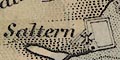
Saltern
each with a windmill, for pumping brine, and with a clear salt
pan at the last.
|
|
| top of page |
|
|
| MAP FEATURES |
- inland features |
relief
hill hachuring
|
Some hills are shown by hill hachuring, and labelled, eg:-
Portsdown Hill
along which visible features on the ridge are noticed -
Nelson's Monument, Chalk Pit, Fir Garden, Portsdown Mill,
etc.
|
beacons
|
None of the old beacon system are on this chart, but between
Portsmouth and Southsea are two posts with a rectangular tops
labelled:-

Beacons
These may not be warning beacons at all but just sea marks to
aid navigation.
|
woods
trees
|
A few patches of woodland are noticed for their value as sea
marks. On Portsdown there is:-
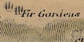
Fir Gardens
Six Clumps
the last being five groups of three fir tree symbols.
|
county
|
The county boundary Sussex/Hampshire is not noticed.
|
settlements
|
Settlements near the coast are shown. The larger places have a
street plan with shading for built up areas, tinted red; smaller
places are marked by groups of dots. Labelling has three styles;
upright block caps:-
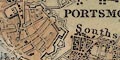
PORTSMOUTH
PORTSEA
GOSPORT
upright lowercase text, eg:-
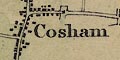
Cosham
Havant
Hamble
and italic lowercase text, eg:-
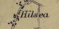
Hilsea
Wimmering
Hill Head
also used for any other feature.
|
roads
|
Roads are drawn by double line, connecting settlements that
are on the chart.
|
railways
|
Railways are drawn by a double line with cross lines, and
labelled:-

Chichester and Brighton
Railway
Southampton and Gosport
Southampton and Brighton
Railroad
|
canals
|
Vestiges of two canals can be seen. The stub of the Arundel
Canal between Milton and the coast of Portsea Island is drawn by
a straight double line, labelled:-
Canal
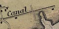
And the Titchfield canal is implied by the drawing of river
and haven at Hill Head.
|
miscellaneous
|
|
mills
windmills
|
Windmills, drawn by a drawing of a tower mill or post, are
useful sea marks. Several are shown, some are labelled, for
example:-
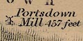
Portsdown Mill 457 feet
Dock Mill
Mill [near Lumps Fort]

Unlabelled, W of Forton Lake.
|
telegraphs
|
Some telegraphs are noticed. There is a:-
Semaphore
on Portsdown above Farlington. And south of the castle, on
Calshot Spit is:-

Old Telegraph
|
|
| top of page |
|
|
| ADMIRALTY |
SURVEYING INSTRUCTIONS, 1851 |
|
|
These notes are taken from the Surveying Instructions issued
by the Admiralty about 1851.
|
|
GENERAL INSTRUCTIONS FOR THE HYDROGRAPHIC SURVEYORS OF THE
ADMIRALTY.
|
|
[footnote] Similar instructions have been issued to the officers
in charge of the various Admiralty Surveys during the last twenty
years; but, to save the trouble of making further copies, it has
been thought expedient to print, in this general form, those
which apply equally to all surveys in any part of the world, and
to reserve for a separate communication such as are only locally
applicable.
|
|
General Objects.
|
1. THE general object of a Hydrographc Survey is to produce such
a chart that every part of a sea-coast may by at once recognised
by a stranger, so that he may without hesitation perceive the
best manner of approaching or receding - of passing or quitting
it - of maintaining a fit position in the offing - or of entering
its ports without the aid of a pilot; and all, under every
condition of weather, wind, and tide.
|
|
Conditions of a good
Chart.
|
2. To effect this purpose, much more must be given than a mere
outline of the shore with its general soundings and its offlying
dangers: a perfect chart should at one glance convey to the eye,
not only the relative position of its principal points and
inflexions, but its varying character - whether springing
abruptly from the sea in precipitous cliffs, or rising in bold
acclivities, or in gentle slopes - whether broken into scattered
points of rock, or throwing itself out in salient prongs and
shelving ledges - whether its bays are encumbered with foul
ground, or or lined with smooth open beach - and especialy
whether it is easily accessible, with regularly decreasing
soundings, or fronted by intricate banks, and unconnected reefs,
which, to pass through or to avoid, require a well-concerted
series of sea-marks.
|
|
General Objects
|
3. In such a chart the extent of the shoals, with the limits of
the intervening channels, should be so manifest, the set of the
tides so consistently expressed, and the directions so terse and
simple, that by the rapid opening or closing of the marks, and
the fulness and sequence of the soundings, the mariner should be
able to trace the movement of his vessel in every fresh cast of
the lead, and thus to feel his way with equal decision,
promptitude, and confidence.
|
|
4. The topographic portion also of such a chart should have a
corresponding degree of completeness: it should contain not only
all the principal features which are conspicuous from the offing,
but even the secondary objects which by their relative situations
may serve to lead forward the eye to those that have been
selected for sea-marks. And as it is of great importance that
those marks should be instantly discernible, some slight
descriptive information might be very advantageously annexed
either to them or to the objects which serve to point them out;
for instance, suppose a clump of trees to be the cross-mark
denoting the entrance to some winding channel - will not the
anxious seaman pick out this clump from the surrounding scenery
with more immediate certainty if the chart tells him whether it
consists of slender poplars or wide spreading oaks? - again, a
series of cliffs may duly and correctly appear in the chart, yet
how satisfactory to have some idea of their relative heights, or
to learn that certain parts of them are red or white, or
moss-grown, perpendicular or stratified, &c.
|
|
5. In short, during the whole prgress of a survey, it should be
steadily borne in mind, that with whatever skill and labour it
may be executed, it is only the means to an end; and that its
real merit will less depend on the science and taste which have
been employed in its construction than on the practical utility
of its results. Maps and charts may indeed be made to convey a
very wide range of information, if properly compiled and
dexterously arranged - the more necessary matters being made
obvious and patent, and the others kept in due and relative
subordination; but what the seaman chiefly wants is a chart
exhibiting at one view all that may be necessary for the
immediate conduct of his vessel; and to have that graphically and
perspicuously expressed without indecision or ambiguity.
|
|
The instructions continue in the same clear way for the
guidance of the surveyor. The general remarks for the design of a
chart are useful guidance for 'designers' of many sorts of
'media'.
|
|
| top of page |
|
|
| REFERENCES |
|
|
|
: 1849: Catalogue of Charts, Plans, Views, and Sailing Directions, etc:
Admiralty & HMSO |
|
|
|
ITEMS |
in HMCMS Map Collection (scanned item in bold)
|
|
|
HMCMS:FA1992.1.1 -- chart
|
|
| top of page |
|
 |
All Old Hampshire Mapped Resources |