 Map Group SPEED 1695


The arms used by John Speed were those of the Stuarts, of James VI and I who reigned 1603-25. By 1695 William III and Mary were on the throne, and the arms should have been changed accordingly; all that was needed was an inescutcheon with the arms of Nassau.
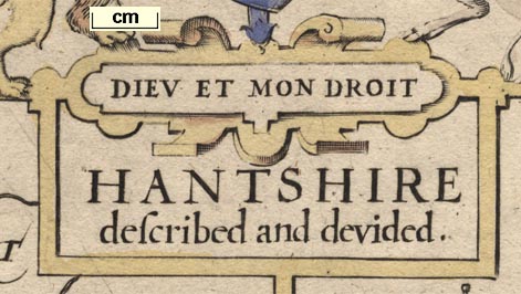
strapwork cartouche
as original
HANTSHIRE described and devided.
publisher
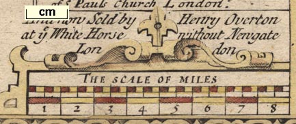
Corrected and Sold by Christopher Browne at the Globe near the West end of S. Pauls Church London.and fitted into a space below the cartouche:-
And now Sold by Henry Overton at ye White Horse without Newgate London
sea plain
sandbanks

A sandbank, shown by pecking, is added off Rames Head; the sea area labelled:-
Spitt head
coast shaded
castles

South Sea Castle
New Mill fluis added to the River Hart.
tents
tribal areas
ALAUNI. FLU OSTIUM
YTEME

REGNUMdistanced from the town?
CAER SEGONTE
VINDONUM
CLAUSENTUM
VENTAThis is usually Venta Belgarum

THE BELGIAElabel S of Winchester, usually Belgae;
THE REGNIlabel N of Southampton;
THE SEGONTIANSlabel S of Silchester.
The lettering of all these additions is in decorative italic block caps.

There are also two 'tent' symbols added; on the north edge of Southampton, and to the south of Winchester.


road distances


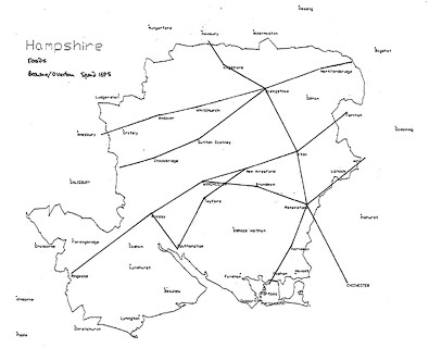
The major addition to the map is a network of roads, drawn by a double line. Mostly the lines are solid, but between Kingsclere and Basingstoke one line is dotted, which became the convention for an unfenced road edge. The road engraving usually avoids interfering with existing engraving. Some roads are continued over the county boundary, in a couple of instances to a town outwith the county. Elsewhere the road stops abruptly inside the county. It is not always clear whether a road goes through or by a place.
The roads are:-
from the Surrey border south of Blackwater, through Herford bridg, Hertley Rowe, Basingstoke, through or by Overton, through Whitchurch, Husborne, Andover, Abbotsham, and passing between Quarley and Grateley, Hampshire; into Wiltshire.Equivalent to the Hampshire parts of John Ogilby's plates 25/26, the London to Lands End road; it should enter Hampshire at Blackwater, the map has the road's course about right, but Blackwater is plotted too far north.
from Surrey; through Lippocke, Petersfield, Beryton, Harneden and Oosham (sic), Hampshire, and across Ports Creek but no further.Equivalent to the Hampshire part of John Ogilby's plate 30, the London to Portsmouth road; it should continue to Portsmouth.
John Ogilby's plate 32 is not represented.
from Petersfield through Bramdean, to Winchester, Hampshire.Equivalent to the Hampshire part of John Ogilby's plate 39 a branch of the London to Chichester road; the section of road entering from Midhurst, Sussex, is not shown.
from Fernham, Surrey; through Alton, Alresford, Morested, Otterburne, to Southampton, Hampshire.
AND continuing from Southampton to Romsey, Hampshire.Equivalent to John Ogilby's plate 51, the London to Southampton road continued to Salisbury; the segment of road, crossing Hampshire, from about Bagshot, Surrey is not shown; the last part of the road is different, crossing the Itchen about Otterbourne, and south as part of Ogilby's plate 97; the continuing road from Romsey to Salisbury is not shown.
from Basingstoke through Sutton [Scotney], Stokbridg, and Broughton, to West Titherley.Equivalent to John Ogilby's plate 53, the London to Weymouth road; the continuation into Wiltshire is not shown.
from Berkshire; through Kingscler, Basingstoke, Alton, and Petersfield, Hampshire; then to Chichester, Sussex.Equivalent to the Hampshire part of John Ogilby's plate 81, the Oxford to Chichester road.
John Ogilby's plate 83 is not represented.
from about Alresford, through Winchester, Rumsey, and Ringwood, Hampshire.Equivalent to some of the Hampshire parts of John Ogilby's plate 97, the London to Poole road; the continuation into Dorset is not shown; a couple of side trunings are suggeste just before Ringwood, the road from Dorset through Christchurch to Lymington is not shown; the road from Southampton to Winchester is drawn as far as Otterbourne as noted above.
Some road distances are given in a little oval cartouche on the road, eg:-

10:2between Winchester and Romsey. The end points of the segments are not clear. The match of distances to the mile positions given on John Ogilby's strip maps is not exact; it is not always easy to read his miles and furlongs. Very roughly:-
plate 25:-
Ogilby: Basingstoke 11'4 Whitchurch 6'6 Andover
Browne: Basingstoke 11'4 Whitchurch 6'7 Andoverplate 30:-
Ogilby: Petersfield 13'3 Cosham
Browne: Petersfield 20'2 Coshamor:-
Ogilby: Petersfield 17'7 Portsmouth
Browne: Petersfield 20'2 Portsmouthplate 39:-
Ogilby: Petersfield 18'2 Winchester
Browne: Petersfield 18'2 Winchesterplate 51:-
Ogilby: Alton 9'6 Alresford ... Southampton 8'2 Romsey
Browne: Alton 9'6 Alresford ... Southampton 8'3 Romseyplate 81:-
Ogilby: Kingsclere 9'2 Basingstoke 10'5 Alton 12'5 Petersfield Chichester
Browne: Kingsclere 9'1 Basingstoke 10'5 Alton 12'5 Petersfield 14'7 Chichester


Published in a collection without title page, by Christopher Brown, 1695.
Published in 'England Fully Described in a Compleat Sett of Mapps of ye County's of England and Wales, with their Islands, Containing in all 58 Mapps. Printed & Sold by Henry Overton at ye White Horse without Newgate London.' 1713.
Published again in 'England Fully Described in a Compleat Sett of Mapps of ye County's of England and Wales, with their Islands, Containing in all 58 Mapps by John Speed. Reprinted Anno, 1743. Printed & Sold by Henry Overton at ye White Horse without Newgate London.' 1743.
Published in 'The English Atlas, or a Complete Set of Maps of all the Counties of England and Wales.' C. Dicey & Co.4, in Aldermary Church Yard; London, 1770.


