
 Map Group SPEED 1611



Whose merits to me-ward I do acknowledge in setting this hand free from the daily imployments of a manuall Trade, and giving it his liberty thus to express the inclination of my mind.
very rare and ingenious capacitie in drawing and setting forthe of mappes and genealogies ...
The / Theatre / of the Empire / of Great / Britaine: / Presenting / An Exact Geography / of the Kingdomes of England, / Scotland, Ireland, / and the Iles adioyning: / with / The Shires, Hundreds, Cities and / Shire-townes, within ye Kingdome / of England, divided and / described / By / Iohn Speed. / Imprinted at London / Anno / Cum Privilegio / 1611 / and are to be solde by Iohn Sudbury & Georg / Humble in Popes-head alley at ye signe of ye white Horse.
... mine owne travels through every province of England ...
... my many additions, and dimensions of the Shire-townes and Cities true platformes ...
I have put my sickle into other mens corne ...
The Shires divisions, into Lathes, Hundreds, Wapentakes and cantreds ... I have separated
... some have bene performed by others, without scale annexed, the rest by mine owne travels, and unto them for distinction sake, the scale of paces.


strapwork cartouche
map maker
publisher
engraver
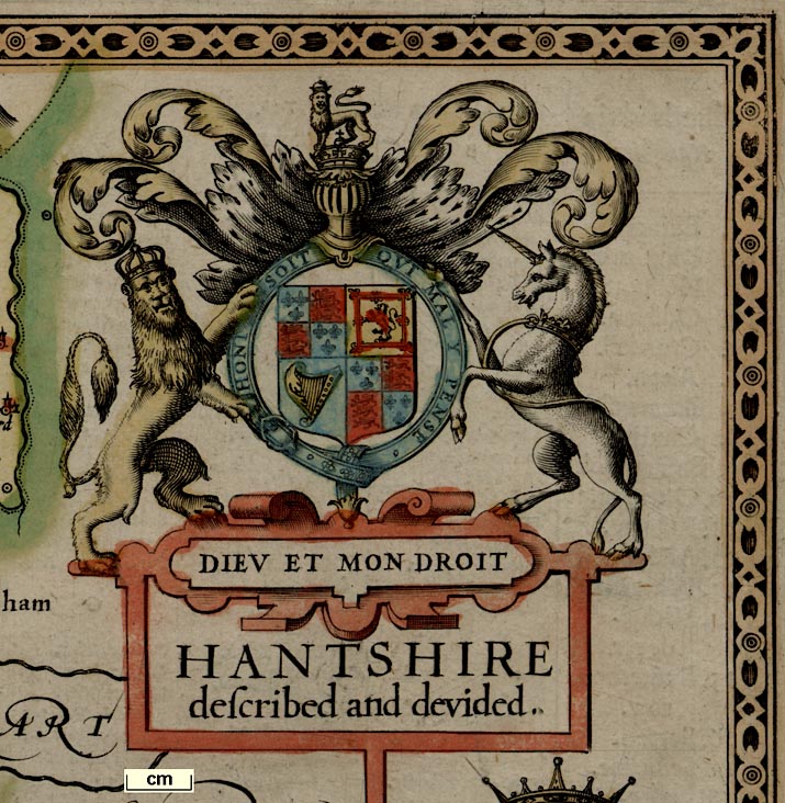
HANTSHIRE / described and devidedprinted in a strapwork cartouche.

In a plain cartouche attached to the scale line is the map makers name, etc:-

Performed by Iohn Speede and are to be solde in Popes / head alley by I. Sudbury and G. Humbell. Cum Privilegio.The engraver has put his name about centre bottom:-
Iodocus Hondius caelavit
DIEU ET MON DROITand:-
HONI SOIT QUI MAL Y PENSE

The coat of arms is that of the period, which is not the same as today's:-
Quarterly 1. and 4., quarterly i and iiii azure three fleur de lys or (France), ii and iii gules three lions passant guardant or (England); 2. or a lion rampant within a tressure flory counter flory gules (Scotland); 3. azure a harp or stringed argent (Ireland).With crests and supporters.

labelled borders
SEPTENTRIO
ORIENS
MERIDIES
OCCIDENS

For north, east, south, and west. There is no compass rose.
scale
old english mile
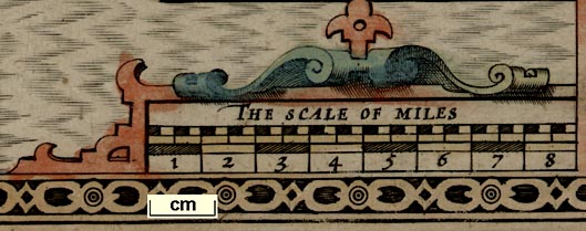
THE SCALE OF MILES

8 miles, chequered in chequered in quarter miles; within a strapwork cartouche. The 8 miles = 65.3 mm gives a scale, wrongly assuming a statute mile, 1 to 197163. The map scale is about:-
1 to 200000
3 miles to 1 inchA better estimate of scale can be made from town positions, comparing known town-town distances using DISTAB.exe. The map scale is about:-
1 to 240000
4 miles to 1 inchThe map maker's mile is an:-
Old English Mile = 1.22 statute miles

bottom left SY852893
top left ST968790
top right TQ174634
bottom right TV058737
sea moire effect
sandbanks

Sandbanks are indicated by dotted areas.
coast shaded
headlands
harbours

Some coast landforms are labelled, eg:-
Black Cliffe
Hengestbury headeSome harbours are labelled, eg:-
Hamble haven.
castles

Hurst castle
Calshot castle
S Andrews castle
Worth cast
South castleThere is no indication of fortifications at Portsmouth, Southampton, Cosham, etc
bridges

There are some bridges shown, eg at Ringwood and Fordingbridge.

A lake is shown at Elvetham and one at Highclere Park. There is a pond near Farnborough:-

hillocks

Selborne Beacon with 1 post

Popham Beacon with 3 posts
There is a tower on a hill by Bursledon, what is this?
forests

Beare Forest
Newe Forrest
LinwoodThere are some forests without any trees, but labelled:-
Buckholt Forrest
Chure Forrest
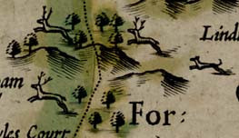
West ForrestIn the New Forest there is a splendid group of deer leaping through trees and hills, chased by a hound.
Preu park

But others are only named by implication from the enclosed settlement name - the settlement may be just the park house etc.


ALTON HUNDRED

In the labelling a tilde (~) is used for internal abbrevaition, and a stop (.) for truncation; a colon (:) is taken to mean hyphenation which can be joined up when transcribing

circle, dot, lots of buildings; upright block caps, eg:-
Winchester

circle, dot, buildings, tower; slightly larger lettering, upright, eg:-
Ringwoodlarge town has more buildings, slightly larger lettering, upright, eg:-
Southampton

circle, dot, tower; small italic lettering, eg:-
Crawleyvarious styles, with perhaps a little building besides

circle, dot; small italic lettering, eg:-
Burley

circle, dot, upright spike; small italic lettering, eg:-
Exbury

circle, dot, carrette; small italic lettering, eg:-
Paultons

circle, dot, cross; small italic lettering, eg:-
Magdelyne
Malwood Castle
windmills
water mills

A spiked circle on the river between St Mary Bourne and Hurstbourne is believed to show a watermill

Bascomb copperashouse

There is a scene depicting the escape of Maud from Winchester in 1141; a litter carried by two horses, with attendant guard with weapons trailing, passing by ?siegeworks and armed soldiers. And a caption:-
The warrs betwixt Maud the Emprese (intituled Lady of England unto whom all the Nobility had sworne Aleagance) And King Stephen Earle of Bolleigne her Cosin germane, was prosecuted with such variable fortune in many conflicts on both partes: that Stephen himselfe was by her taken prisoner and reteyned in Irons with other exstremityes used, But succese of warr altering, Maud the Emprese to save her owne life adventured throwe the Host of her enimie, layde in a coffin fayned to be dead, and soe was caryed in a horse-litter from Winchester to Lutegershall Vices, and Gloucester; and thence to Oxford, whence the yere following she escaped as dangerously by deceaving the Scout watch in a deepe snowe. Anno 1141.Except for this vignette there is no indication of antiquities.
coat of arms
colouring
BOGO or BEAVOUS / Earl of Southamp / ton a famous warrier / against ye Normans.
WIILLIAM FITZ / William created Earl / of Southampton / by Kinge Henry 8.
THO. WRIOTHEOS: / LEY created Earle of / Southampton by / K. Edward 6. Anno. 1.
CLITON a Saxon / Earle of Winchester
SAER QUINCY Earle / of Winchester
HUGH SPENCER / Earle of Winchester.
LODOWICK BRUGET / Earle of Winchester.
WILLIAM PAULET / Marquess of WinchesterThere are small letters of the alphabet in the quarters of coats of arms. These stand for the tinctures and furs used in heraldry. From other sources the letters to look for are:-
O - or, gold, use yellow - series of dots
A - argent, silver, uncoloured
G - gules, red - vertica lines
AZ - azure, blue - horizontal lines
V - vert, green - lines diagonally left to right
P - purpure, purple - lines diagonally right to left
S - sable, black - cross hatched vertical and horizontal
T - tenne, tawney, use orange - cross hatched diagonally
See below for more about Coats of Arms.
streets
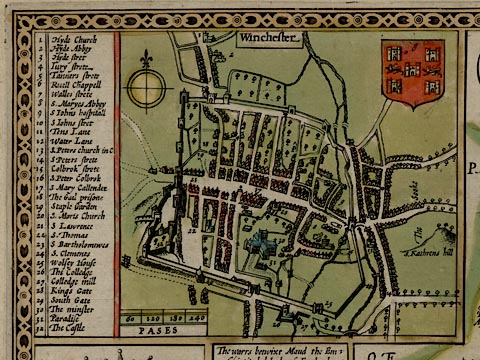
There is an inset street map of Winchester.
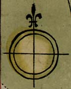
Compass rose indicating the cardinal points by lines, north marked by a fleur de lys.
There is a scale line of 240 paces:-
PASESmarked at 60, 120, 180, 240

The coat of arms of Winchester is shown.
Streets and inportant buildings are keyed by number to a table of contents. The map shows streets, houses and some gardens, town wall and gates, bridges and the braided River Itchen, Winchester cathedral and other churches, mills, Winchester College, etc


EARLS OF WINCHESTER
gules, six crowns 3,2,1 orPapworth's Ordinary lists Cliton or Clinton, saxon Earl of Winchester with these arms.
gules, seven mascles 3,3,1 orSaer de Quincy was a powerful baron, an enemy of John, but created Earl of Winchester by him. He was one of the 25 barons appointed to enforce the observance of the Magna Carta; he died on pilgrimage in the Holy Land. His arms are described by Portal:-
or, a fesse gules, a label of twelve points azurewhich is quite different! Longbottom confirms this last for Saher de Quincy, Earl of Winchester, 1219.
quarterly argent and gules, 2 and 3 a fret or, overall a bend sableHugh le Despencer was a favourite of Edward II and was created Earl of Winchester 1322 after the de Quincy family had died out. He suffered an ugly death after surrendering Bristol to Queen Isabella, defending it against her for her husband Edward. Isabella had him hung and quartered, his body thrown to the dogs, his head sent to Winchester to be displayed on a pole on the castle gate.
azure, ten mascles, 4,3,2,1 or, a canton gules a lion passant guardant of the secondThis is also described by Papworth for Lewis de Bruges, 4th earl of Winchester.
sable, three swords in pile, points in base, argent hilted gules, a crescent for a differenceThe description of the coat of arms varies from person to person: the pomels and hilts might be gold (or); and there might be a 'difference around' a bordure ermine.
The 1st marquess, William, died 1572. His eldest son was also William.
azure, three lions passant guardant orThese are, of course, the arms of England used by Edward I and many others. Portal pictures the lions arranged 2,1 not in the usual arrangement as on Speed's map.
Sir Bevois of Southampton was a champion of english Christianity against danish heathenism, a great saxon chief, son of Guy, Earl of Southampton. He is said to have thrown up Bevois' Mount near the town, to bar the river passage to the Danes. ... and other tales ...
1 lozengy argent and gules - which Papworth lists for William Fitz William, Earl of Southampton 2 gules, a saltire argent, a label for a difference - unidentified 3 argent, 3 lozenges conjoined in fesse gules - which might br Montacute, following Papworth 4 or an eagle displayed wings elevated gules ... or perhaps ... armed gules - unidentified
azure, a cross argent between four falcons close orwhich is in the 1st quarter of the arms on Speed's map.
The 2nd quarter of the arms is a bit like those of 'Bill' described by Berry:-
or, a fret sable within a bordure engrailed azure, on a canton argent, five martlets in saltier, of the second3 argent five fusils conjoined in pale gules, a bordure sable charged with seven bezants or (??) - unidentified 4 per pale indented gules and azure, a lion [rampant] or (??) - unidentified


HAnt-shire by the Saxons written Handescyr, lying upon the west of Engla~d, is bordered upon the North by Barkshire, upon the East with Surrey and Sussex, upon the South with the British Seas, and Ile of Wight, & upon the West, with Dorset and Wilt-shires.
(2) The length thereof from Blackwater in the North upon Surrey, unto Bascomb in the South upon the Sea, extended in a right line, is fifty foure English miles: and the breadth drawne from Petersfield in the East, unto Tidworth in the west, and confined of Wilts-shire, is little lesse than thirty miles, the whole Circumference about, one hundred fifty and five.
(3) The aire is temperate, though somewhat thicke by reason of the Seas, and many Rivers that thorow the Shire doe fall, whose plenty of fish and fruitfull increase, do manifoldly redeeme the harmes which they make.
(4) The Soile is rich for corne and cattle, pleasant for pasturage, and plenteous for woods; in a word, in all commodities either for Sea or Land, blessed and happy.
(5) Havens it hath, and those commodious both to let in, and to loose out ships of great burthen in trade of Merchandise, or other imploiments: whereof Portsmouth, Tichfield, Hamble and Southampton are chiefe: beside many other creekes that open their bosomes in those Seas, and the Coast strengthned with many strong Castles, such as Hurst, Calshot, South-hampton, S. Andrewes, Worth, Porchester, and the South Castle, besides other Bulwarkes, or Block-houses that secure the Country: And further in the Land, as Malwood, Winchester, and Odiam, so strong, that in the time of King John, thirteene English men onely defended the Fort for fifteene daies against Lewis of France, that with a great Host assaulted it most hotly.
(6) Anciently it was possessed upon the North by the Segontians, who yeelded themselves to Julius Caesar, & whose chiefe Citie was Vindonum, Caer Segonte, now Silcester; and upon the South by the Belgae, and Regni, who were subdued by Plausius and Vespasian the Romans, where Titus rescuing his father, straitly besieged by the Britaines, as Dio and Forcatulus do report, was grasped about with an adder, but no hurt to his person, and therefore taken for a signe of good lucke. Their chief Towne was Rincewood, as yet sounding the name: and more within Land inhabited the Manures, as Beda calles them, whose Hundreds also to this day give a relish of their names.
(7) Neere Ringwood, and the place once YTENE, from God and people's service, to Beast and luxurie, thirty sixe Parish Churches were converted and pulled downe by the Conquerour, and thirty miles of circuite inforrestred for his game of Hunting, wherein his Sons Richard and Rufus, with Henry the second sonne to Duke Robert, his first, felt by hasty death the hand of Justice and Revenge: for in the same Forrest, Richard by blasting of a pestilent aire, Rufus by shot taken for a beast, and Henry as Absolom hanged by a bough, came to their untimely ends. At so deare a rate the pleasures of dogs, and harbour for beasts were bought in the blood of these Princes.
(8) The generall commodities gotten in this Shire, are woolls, Cloths and Iron, whereof great store is therein wrought from the Mines, and thence transported into all parts of this Realme, and their Clothes & Karsies, carried into many forrain Countries, to that Countries great benefit, and Englands great praise.
(9) The Trade thereof, with other provisions for the whole, are vented through eighteen Market Townes in this Shire, whereof Winchester, the Britaines Caer Gwent, the Romans Venta Belgarum, & the Saxons Windaneasder is chiefe, ancient enough by our British Historians, as built by King Rudhudibras, nine hundred yeeres before the Nativitie of Christ: and famous in the Romans times for the weaving and embroideries therein wrought, to the peculiar uses of their Emperours owne persons. In the Saxons time, after two Calamities of consuming fire, her walles were raised, & the Citie made the Roiall seate of their West Saxons Kings, and the Metropolitan of their Bishops Sea, wherein Egbert and Elfred their most famous Monarchs were Crowned: & Henry the third, the Normans longest raigner, first tooke breath: And here king Aethelstane erected sixe houses for his mint: but the Danish desolation over-runnig all, this Citie felt their furie in the daies of king Ethelbright, and in the Normans time, twice was defaced by the misfortune of fire, which they againe repaired and graced with the trust of keeping the publike records of the Realme. In the Civill warres of Maud and Stephen, this City was sore sacked, but againe receiving breath, was by King Edward the third, appointed the place for Mart of wooll and cloth. The Cathedrall Church built by Kenwolf king of the West Saxons, that had beene Amphibalus, S. Peters, Swythins, and now holy Trinity, is the Sanctuary for the ashes of many English Kings: For herein great Egbert, Anno 836, with his sonne king Ethelwolfe, 857: here Elfred, Oxfords founder, 901, with his Queene Elswith, 904: Here the first Edmund before the Conquest, 924, with his sonnes Elfred, and Elsward: Here Edred, 955, and Edwy, 956, both kings of England: Here Emme, 1052, with her Danish Lord Canute, 1035, and his sonne Hardicanute, 1042: And here lastly the Normans, Richard and Rufus, 1100, were interred; their bones by Bishop Fox were gathered and shrined in little guilt coffers fixed upon a wall in the Quire, where still they remain carefully preserved.
This Cities situation is fruitful and pleasant in a vally under hilles, having her River on the East, and Castle on the west, the Circuite of whose walles, are well neere two English miles, containing one thousand eight hundred and eightie paces; thorow which openeth sixe gates for entrance, and therein are seven Churches for divine service, besides the Minster, and those decaied; such as Callender, Ruell Chappell, S. Maries Abbey, & the Friers, without in the Suburbes, and Sooke; in the East is S. Peters, & in the North Hyde Church and Monasterie, whose ruines remaining, show the beautie that formerly it bare. The Graduation of this Citie by the Mathematicks, is placed for Latitude in the degree 51 10 minutes, and for Longitude 19, 3 minutes.
(10) More south, is South hampton, a Towne populous, rich and beautifull, from whom the whole Shire deriveth her name, most strongly walled about with square stone, containing in circuit, one thousand and two hundred paces, having seven Gates for entrance, and twenty nine Towres for defence, two very stately Keies for Ships arrivage, & five faire Churches for Gods divine service, beisdes an Hospitall called Gods house, wherein the unfortunate Richard, Earle of Cambridge, beheaded for treason, lyeth interred. On the west of this Towne is mounted a most beautifull Castle, in forme Circular, and wall within wall, the foundation upon a hill so topped, that it cannot be ascended but by staires, carying a goodly prospect both by Land and Sea, & in the East without the walles, a goodly Church sometimes stood, called S. Maries, which was pulled down: for that it gave the French direction of course, who with fire had greatly endangered the Towne: in stead thereof is now newly erected a small and unfinished Chappell. In this place, saith learned Campden, stood the ancient Clausentium, or fort of the Romans, whose circuit on that side extended it selfe into the Sea: this suffered many depredations by the Saxon Pirates, and in Anno 980, was by the Danes almost quite overthrowne. In king Edward the thirds time, it was fired by the French, under the Conduct of the king of Sicils sonne, whom a Country man incountred and strucke downe with his Club, He crying Rancon, that is, Ransome: but he neither understanding his language, nor the law that Armes doth allow, laid on more soundly, saying: I know thee a Frankon, and therefore shalt thou die: and in Richard the seconds time it was somewhat removed, and built in the place where now it standeth. In this Clausentium, Cannute to evict his flatterers, made triall of his deitie, commanding the seas to keepe backe from his feate: but being not obeyed, he acknowledged God to be the onely supreame Governor, and in a religious devotion gave up his Crowne to the rood at Winchester. More ancient was Silcester built by Constantius, great Constantines sonne, whose monument (they say) was seene in that Citie and where another Constantine put on the purple roabe against Honorius, as bot Ninnius and Gervase of Canterburie doe witnes. Herein by our Historians record, the warlike Arthur was crowned. Whose greatnesse for circuite contained no lesse then fourescore acres of ground, and the walles of great height, yet standing two miles in compasse about.
This Citie by the Danish Rovers suffred much wracke, that her mounted tops were never since seene, and her Hulk (the walles) inmured to their middle in the earth, which the rubbish of her owne desolations hath filled.
(11) Chiefe Religious houses within this Countie erected and againe suppressed were these, Christs-Church, Beaulieu, Whorwell, Rumsey, Redbridge, Winchester, Hyde, South-Hampton, and Tichfield. The honour of this shire is dignified with the high Title of Marques, and them Earles of Winchester and South-Hampton; whose armes of families are as thou seest, and her division into thirty seven Hundreds, and those againe into two hundred fifty three Parishes, as in her Table shall appeare.


MAP FEATURES
strapwork-
cartouche
map maker
publisher
THE KINGDOME OF GREAT / BRITAINE AND IRELAND / by I. Speed.And printed lower right in another strapwork cartouche is:-
Are to be sold by Tho: Bassett / in Fleet street and Ric: Chiswell / in St. Pauls Churchyard.The map was first published in 'The Theatre of the Empire of Great Britaine ...' by Sudbury and Humble in 1611. This copy of the map is from a later edition of the atlas, published by Bassett and Chiswell, 1676. The plate continued in use for many more years.
coat of arms
inset map
On the left is the royal coat of arms of the Stuarts; those of James VI and I, the first sovereign of 'Great Britain', when Speed drew the map, and of Charles II when this later edition was published. The blazon is:-
quarterly 1. and 4., quarterly i and iiii azure three fleur de lys or (France), ii and iii gules three lions passant guardant or (England); 2. or a lion rampant within a tressure flory counter flory gules (Scotland); 3. azure a harp or stringed argent (Ireland).Below is a view of:-
LONDONwith the
Thames fluviusand London Bridge and old St Paul's Cathdral which had not yet burned down. Below again is a medallion with a figure that could be an early version of Britannia seated on a globe, lettered:-
IMPERAT / S C / BRITANNIAOn the right is an inset map for:-
THE / ILES OF / ORKNAYThen a view od:-
EDYNBURGHfrom Holyrood Palace to Edinburgh Castle. And below a medallion, a kings head, lettered:-
CUNOBILINThis is Cunobelinus or Cymbeline, king of the Catuvellauni, recognised as the king of Britain by the Romans about AD5.
compass rose
up is N
labelled borders
Additionaly, the map's four borders are labelled:-
NORTH
EAST
SOUTH
WEST
lat and long grid
The projection has the size on paper of 1 degree latitude the same from south to north, as well as I can judge. 8 degrees latitude is 275.0 mm giving a scale for the map about 1 to 3238351. The map scale is about:-
1 to 3200000
51 miles to 1 inch
scale
map maker
old english mile
dividers
Performed by John SpeedeIn the cartouche labelled:-
The Scale of Milesare two scales. The upper is chequered in 5 miles intervals labelled in tens, for:-
Common :Mill.which has 80 miles = 57.1 mm giving a scale 1 to 2254773, a map scale about:-
1 to 2300000
36 miles to 1 inchThese are the map maker's miles which seem to be about 1.4 statute mile, which had not become statute at that period. The map provides an estimate of the common Old English Mile = 1.4 statute mile, greater than the usual range of values for this obscure historical unit.
The lower scale is:-
By Degreeswhich has 100 miles in the place of 80 common miles. This gives a scale about:-
1 to 2800000
44 miles to 1 inchand I don't know how to imterpret this!
It would be possible to get a good estimate of the map's scale by measuring the positions of a couple of dozen towns and comparing their distances from each other with their known distances - a fair bit of work.
sea plain
swash lettering
flags
beasts
sea monsters
ships
THE DEUCALIDON SEA
THE IRISH SEA
THE BRITISH SEA
THE WEST OCEAN
THE GERMAN OCEANThe last two in florid swash lettering to fill otherwsie empty space on the map.
The sea is decorated with a couple of ships, sea monsters, and 'royal beasts' carrying flags of the three nations of Great Britain.
The ships are crudely drawn two masted carracks. That on the left seems to have pointed ends, not a flat stern with rudder. Three ships' flags appear to be the flag of Aragon, Spain, horizontal bands, red yellow red (but we don't know who coloured the map or when).
Three of the monsters in the sea are interesting. There is a lion carrying the standard of England; a unicorn carrying the standard of Scotland; and some other mythical beast carrying the standard of Ireland.
coast shaded
bridges
Severn flu.
Thames mouth
Aestuarium Fyrth(In case your lost the last is the Forth.)
Judging by Hampshire the coverage is not bad. All its major river systems are shown with some tributaries. Errors of drawing do put some rivers out of the county!
A few bridges are marked by a double line across a river. For example, looking at Hampshire, at Stockbridge.
hillocks
forests
county
HANTSHIRE
WILTSHIRE
London
Winchester
Andoverbut this symbol is also used for The Vine, which is just a great house, Hurst Castle, etc. Calshot Castle has only a dot and circle.


HANTSHSIREwhich then includes the Isle of Wight and the area of [now] Dorset around Christchurch, are:-
Andover
Aulton
Basingstok
Calshot
Hurst ca
Kingesclere
Odyham
Porchester
Portesmouth
Ringwood
S. Hampto~
Stoke bridg
The Vine
Winchesterand:-
Black rock
Hyde
The Isle of Wight
Newport


INTRODUCTORY PAGES
THE / THEATRE / OF THE EMPIRE / OF GREAT / BRITAINE: / Presenting / AN EXACT GEOGRAPHY / of the Kingdomes of ENGLAND, / SCOTLAND, IRELAND, / and the ILES adjoyning: / With / The Shires, Hundreds, Cities and / Shire-townes, within ye Kingdome / of ENGLAND, divided and / described / By / JOHN SPEED.
IMPRINTED AT LONDON / Anno / cum Privilegio / 1614 / And are to be solde by John Sudbury & Georg / Humble, in Popes -head alley at ye signe of ye white Horse.
TO THE WELL-AFFECTED AND FAVOURABLE READER.
SO great was the attempt to assay the erection of this large and laborious THEATRE, whose onely platforme might well have expected the readiest hand of the best Artist, that even in the entrance of the first draught, as one altogether discouraged, I found my self farie unfit and unfurnished both of matter and meanes, either to build, or to beautifie so stately a proiect.
...
But with what content to thy eye (gentle Reader) I stand in suspence, so many Master-builders having in this Subiect gone before me, and I the least, not worthy to hew (much lesse to lay) the least stone in so beautifull a Building: neither can I for my headlesse presumtion alledge any excuse, unlesse it be this, that the zeale of my Countries glory so transported my senses, as I knew not what I undertooke, untill I saw the charges thereof (by others bestowed) to amount so high as I held it a conscience to frustrate their designements; wherein albeit, it may be obiected that I have put my Sickle into other mens Corne, and have laid my Building upon other mens Foundations (as indeed who can doe otherwise, especially in a subiect of this nature, seeing that the wisest of Kings witnesseth, that there is nothing new under the Sunne) ...
... I cast in my mite, and by my owne travell adde somewhat more then hath beene already divulged, let me crave thy acceptance, ...
A Catalogue of all the Shires, Cities, Bishoprickes, Market Townes, / Castles, Parishes, Rivers, Bridges, Chases, Forrests, and Parkes, conteyned / in every particuler Shire of the Kingdome of England.
Shires / Cities / Bishopricks / Mark Townes / Castles / Parrish church / Rivers / Bridgs / Chases / Forrests / Parkes
Hant-shire / 01 / 01 / 18 / 05 / 248 / 04 / 31 / 00 / 04 / 22


Publication
... By JOHN SPEED
LONDON: Printed for Thomas Bassett at the George in Fleetstreet, and Richard Chiswell at the Rose and Crown in St. Paul's Church-Yard, 1676.
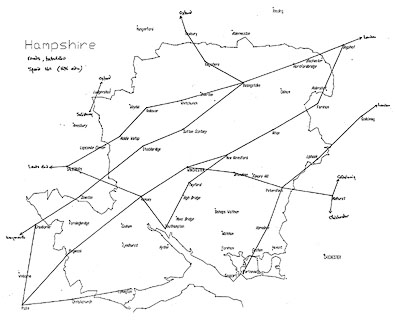
... The Principal Roads ... with their computed distances. In a new and accurate method.
Hampshire Roads
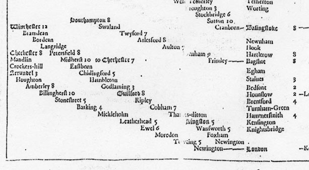
Western Road
The Western-road from London to the Lands-end in Cornwal; and its Branches to several of the principal Towns, with their computed distances..
from London; through Staines, Middlesex; bagshot, Surrey; then Hartlerow, Hook, Newnham, Basingstoke, Worting, Tetherton, Whitchurch, Downhurstborn, Andover, Middle-wallop, Hampshire; to Salisbury, Wiltshire; and beyond to Senan, Cornwall ie Lands End.
branch from Salisbury, Wiltshire; through Cranborn, Poole, Ifford, Christchurch, Dorset; then Somerford, Milton, Evelton, Efford, to Limington, Hampshire.
branch from Salisbury, Wiltshire; through Rumsey, Upton, to Southampton, Hampshire.
branch from Salisbury, Wiltshire; across a corner of Hampshire; to Oxford, Oxfordshire.
branch from Basingstoke, through Cranborn, Sutton, Stockbridge, Broughton, West Tetherley, East-Dean, Hampshire; then through Dunkton, Wiltshire; Cranborn, Blandford, Dorchester to Weymouth, Dorset.
branch from Basingstoke through Kings Clere, Hampshire; then Newbury, Berkshire; to Oxford, Oxfordshire.
branch from Bagshot, through Farnham, Surrey; then Aulton, Arlesford, Twyford, Swaland, to Southampton, Hampshire.
from London; through Godlaming, Surrey; and Midherst, from whence Chichester, West Sussex; then Petersfield, Langridge, Bordean, Bramdean, to Winchester, Hampshire.
West Road
The West-road from London to Bristol; and its Branches to several of the principal Towns, with their computed distances.
from London; through Staines, Middlesex; and Bagshot and Farnham, Surrey; then Aulton, Arlesford, Winchester, Pitt, Hursley, Rumsey, Malwood, Ringwood, Hampshire; to Poole, Dorset.
branch from Arlesford, through Twiford, to Southampton, Hampshire AND from Southampton, through Upton, Rumsey, Hampshire; to Salisbury, Wiltshire.
South Roads
The South-East, South and South-west-roads from London; and its Branches to several of the principal Towns, with their computed distances.
from London; through Godlaming, Surrey; then Lipock, Petersfield, Harnden, Portsey-bridge, Hilsey, Kingstone, to Portsmouth, Hampshire.
branch from Godlaming, Surrey; to Chichester, West Sussex, branching at Midherst; through Petersfield, Langridge, Bordean, Bramdean, to Winchester, Hampshire.


Published in an edition of the atlas printed 1614.
Published, presumably for sale abroad, in a Latin edition 'Theatrum Imperii Magnae Britanniae: Exactam Regnorum Angliae, Scotiae, Hiberniae et Insularum adiacentium Geographia ob oculos ponens uno cum Comitatibus, Centurijs, Urbibus et primarijs Comitatum oppidis, intra Regnum Angliae, divisis et descriptis. Opus, Nuper quidem a Johanne Spedo cive Londinensi, Anglice conscriptum: Nunc vero, a Philemone Hollando, apud Coventrianos Medicinae Doctore Latinitate donatum. Imprinted at London Anno Cum Privilegio 1616 And are to be solde by John Sudbury & Georg Humble in Popes-head alley at ye signe of ye white Horse. 1616.'
Published in 'The Theatre of the Empire of Great Britaine ... by John Speed ... 1627. Are to be sold by George Humble at the Whit horse in Popes-head Alley.'
Published in an edition, after Speed's death in 1631, by George Humble, 1632.
Published in editions by William Humble, 1646, 1650, 1651, 1652, 1653, 1654.
Published in 'The Theatre of the Empire of Great Britaine ... by John Speed. Imprinted at London ... 1650. Are to be sold by Roger Rea the Elder, and Younger, at the Golden Crosse in Cornhill agat: ye Exchange, ...' 1665.
Published in 'The Theatre of the Empire of Great Britaine. ... As also A Prospect of the most famous Parts of the World. By John Speed. With many Additions never before Extant. London. Printed for Thomas Bassett and Richard Chiswell, 1676.'; and noting '... The Principal Roads ... with their computed distances. In a new and accurate method. The Market Towns wanting in the former Impressions. A Continuation of all the Battels fought ... The Arms of all the Dukes and Earls ... to the Last Creation. ... London; Printed for Thomas Basset at the George in Fleet Street, and Richard Chiswel, at the Rose and Crown in St. Paul's Church-yard, MDCLXXVI.' 1676.
Published in another series 'A Catalogue of a Set of Maps of the several Counties of England and Wales with the Islands thereto belonging, each Map is printed on a sheet of good Royal Paper ... Printed and sold by Henry Overton at the White Horse without Newgate, London. Sold either in compleat sets or singly.' 1710.
Published with alterations from 1713, see Speed 1713.


Hodges, C W: 1949: John Speed's Theatre: Theatre Notebook: 3: pp28-31
Potter, Johnathon: 1991: Theatre of Empire of Great Britain: Drayton Manor Publishing:: ISBN 0 9511577 3 6; facsimile
Skelton, R A: 1952: Tudor Town Plans in John Speed's Theatre: Archaeological J: 108: pp109-120
Skelton, R A: 1970: County Atlases of the British Isles 1580-1850: Carta Press:: p.35 about lat and long
Smith, David: 1986: Jansson versus Blaeu: Cartographic Journal: 23: pp 106-14
Tooley: 1949: British Maps and Map Makers: Batsford (London)
Portal, Melville, Sir: 1899: Great Hall at Winchester: Warren (Winchester, Hampshire)
St George, Henry, Sir & Squibb, G D (ed): 1686; 1991 (edn): Visitation of Hampshire and the Isle of Wight 1686: Harleian Society (London)
Wagner, A R: 1961: Papworth's Ordinary of British Armorials: Tabard Publications (London):: which is arranged alphabetically by pictorial elements


