 Map Group VANCOUVER 1810


GENERAL VIEW OF THE AGRICULTURE OF HAMPSHIRE, INCLUDING THE ISLE OF WIGHT. DRAWN UP FOR THE CONSIDERATION OF THE BOARD OF AGRICULTURE AND INTERNAL IMPROVEMENT. BY CHARLES VANCOUVER. EXPERIENTIA PRAESTANTIOR ARTE.
LONDON: PRINTED FOR SHERWOOD, NEELY, AND JONES, PATERNOSTER-ROW: SOLD BY G. AND W. NICOL, PALL-MALL; MOTLEY AND CO. AND MILLS, PORTSMOUTH; ROBBINS, AND JACOB, WINCHESTER; BAKER AND CO. SOUTHAMPTON; AND ALBIN, NEWPORT. 1813. [Price Sixteen Shillings in Boards.]


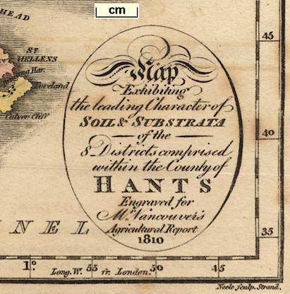
oval cartouche
map maker
engraver

Map Exhibiting the leading Character of SOIL & SUBSTRATA of the 8 Districts comprised in the County of HANTS Engraved for Mr. Vancouver's Agricultural Report 1810Printed at the bottom is:-
Neele sculp. Strand
London. Pubd. Jany. 1st. 1810, by R. Phillips, New Bridge Street.
up is N

Printed in the map borders are rectangular scales for latitude and longitude; chequered at 1 minute intervals, labelled at 5 minutes intervals. The bottom scale states:-
Long. W. fr. London.The longitude of Winchester on the map is about 1 degree 12 minutes W, which accords with a prime meridian about 6 minutes W of Greenwich. Notice that, in error (I assume), the map has 1 degree N marked at the 51 degree parallel. The map covers about 0d 40m to 1d 43m W, 50d 34m to 51d 25m N.
The map extends beyond its printed borders in the NE and SW, and includes the Isle of Wight.
1 to 390000
6 miles to 1 inch
sea plain
ENGLISH CHANNEL
SOLENT
SPITHEAD
Southampton Water
coast shaded
harbours

The coast line is shaded for emphasis.
Portsmouth Har.is labelled.
castles

Hurst Cas.
Calshot Cas.No fortifications are shown around Portsmouth etc.

Beauley River
Avon R.All the major river systems are shown with some tributaries, but not all are named.
forests

Holt Forest
Watmere Forest [Woolmer Forset]
East Bere Forest
New Forestbut no more.

Hackwood Park
Freemantle Pa.
geology
table of symbols
... Exhibiting the leading Character of SOIL & SUBSTRATA of the 8 Districts ... of HANTS ...The districts are delimited by a dotted line and numbered 1..5 in Hampshire, 6..7 in the Isle of Wight. Look hard; the numbers are all there. Each area is tinted:-
1 pale blue green
2 pale yellow
3 pale brown
4 pale green
5 pink
6 pale orange
7 pink
8 yellowAs the map is folded in the book there is no reason to think the colours faded. Examples:-

has 4 pale green to the north, 5 pink to the south;

has 2 plae yellow to the west, 3 pale brown to the east.
Each are is described in a table:-
DISTRICTS
No.1 Woodlands and the Wastes of Bagshot / Clay, Sand, Gravel and Peat
2 Strong Flinty Loams & Hazel Mould on Chalk / occasionally veined with Gravel / Peat in most of the Vallies
3 Malm Sand & Gravelly Loam Clay & Peat / upon the Wastes of Woolmer & Alinholt Forests
4 Light Loams mix'd with Clay & calcareous Marle / Peat in the low Grounds particularly in the Forests Chace &c
5 Chalk of Portsdown with strong flinty Loam / & hazel Loam in the Islands and low Grounds
6 Tough strong Clay & Argillaceous Marle
7&8 Tender Loam with Argillaceous & Calcareous / Marle & chalkLooked at closely the area boundaries are not as clear as that might be.

The county boundary is a dashed line, tinted red alongside Dorset, blue-green alongside Wiltshire, red alongside Berkshire, green alongside Surrey, and red alongside Sussex. The adjoining counties are labelled, eg:-
DORSET SH.On the northern boundary there is an enclosed area which could be the detached part of Wiltshire then hereabouts. The detached part of Hampshire in Sussex is not shown.

WINCHESTER

Alton
HavantSouthampton has italic block caps.

Bentley
Froyle

The map has a network of roads drawn by double lines. The more important roads are drawn wider with one line bolder.

The Basingstoke Canal is shown; not labelled.


