
 Map Group WAGHENAER 1583



WAGGONER
A Sea Grammar, WITH THE PLAINE EXPOSITION of SMITHS Accidence for young Sea-men, enlarged ... Written by Captaine IOHN SMITH, ... LONDON, Printed by IOHN HAVILAND, 1627.
... what Bookes and Instruments are fit for a Sea-man ...
For to learne to observe the Altitude, Latitude, Longitude, Amplitude, the variation of the Compasse, the Sun's Azimuth and Almicanter; to shifte the Sunne and Moone, and know the tides, your Roomes, pricke your Card, say your Compasse, get some of these bookes; but practice is the best.
...
Waggoner
...
THE ARMADA
... careful relation of all the coasts of England with a note of the depth and size of their harbours ...


The map's border is patterned to imitate a carved wooden picture frame.
title
map maker
engraver

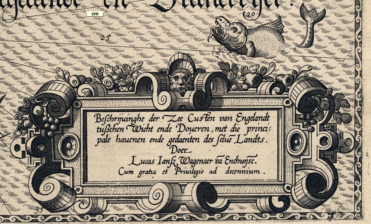
Beschrijvinghe der Zee Custen van Engelandt / tusschen Wicht ende Doveren, met die princi: / pale havenen ende gedaenten des selve~ Landts. / Doer / Lucas Jansz Wagenaer va~ Enchuise~. / Cum gratia et Privilegio as decennium.The cartouche is decorated with a mask, foliage and fruit.
Printed lower left is:-

Jo~es a~ Doetecu~ f.The engraver who made the map was Johannes van Doetecum.
compass rose
rhumb lines
up is N

The map has a compass rose in the sea area with rhumb lines extending as far as the coasts. The rose has star points for cardinal, half cardinal, false and by points. North is marked by a fleur de lys. The labelling looks deceptively familiar until you notice the O for Ost ie East.
Up on the chart is approximately north, about NNWbyN.
scale

Spaensche mijlen tot 17 1/2. in een graedt.
Duijtsche mijlen tot 15. in een graedt.
1.5.83The last figure is the date of the map's engraving.
The scale lines are simply divided and labelled. A crude estimate of the map's scale, from measuring places, is about:-
1 to 470000
7-8 statute miles to 1 inchThe english edition of the sea atlas has a third scale line for english miles. On which 'English leagues 20 in a degree'. There are 7 numbered divisions. 7 leagues = 95.6mm. A league is 3 sea miles; a degree is 69.17 statute miles. Thus the map scale is about:-
1 to 410000
6 1/2 statute miles to 1 inchThe sheets of the two editions being much the same size one could make an assumption that this is a useful good estimate of the scale of the dutch edition.
sea waves
depth soundings
sandbanks
sea marks
sea monsters
ships
anchorages

The sea area is engraved with formalised wave motifs. These seem to be individually engraved, though close study might show that a range of stamps was used I feel that this is unlikely. The sea is labelled:-
Die Canael tusschen Engelandt en Franckrijck'The Channel between England and France'.

Sandbanks in channels and foreshore mudflats along the coast and banks of estuaries are marked by a double line boundary of dots, perhaps filled with more dots. Some of the filling is with crosses, plus signs, which indicate a rocks. The english edition states:-
... The litle Crosses marked in this manner + alonge the Coastes neare Islandes and elswhere, betoken hidden and dangerous Rockes, of which you must carefully beware ...A few of the shallows are labelled, eg:-
Cingelswhich is probably 'Shingles', off the shore of the New Forest, and:-
Elene santie Helen Sands, off St Helens.
The sandbank south of Rye has drawings of posts along its west and south edges, sea marks against the danger. From the english edition:-
... for Sandes, flats & shoaldes do commonly stand the Beakons and other higher and more apparent markes made of Oaysers, after this manner [drawing of a marker post with an ovoid basket on top] that they may be farther of perceaved ...Oaysers is Osiers.

Depth soundings are given in figures placed in the sea area and estuaries, in fathoms, ranging from 1 to 38 fathoms. The english edition gives:-
The figures that are placed in al Have~s Rivers, Streames & Channels, as well as in the mayne sea as elswhere, upo~ al the shoaldes, Sandes & Rockes, do signifie the depth of the places, as 1. 2. 3. 10. 12. fatham, & so forth: which is alwaies to be understood at half flood or ebbe.


Monstrous fish and a galleon decorate the sea area. The ship has a bow sprit with a square sail, foremast with main and top sails, main mast with main and top sails, and a mizzen mast with a lug sail. The stern is square with a central mounted rudder. There is a flag on the main mast (pattern unrecognised).
Some anchorages are indicated by an anchor symbol. The english edition explains:-
... But where there is a salfe roade & grounde fit for Ankering I have set downe this forme of an Anker. [illustration of an anchor]Some of these are in river mouths, ie havens, others:-

Two anchorages are indicated in The Solent by an anchor symbol; north of Cowes, and about St Helens Roads.
Anchorages are indicated west and east of Beachy Head.
An anchorage is shown at the East Road.
coast appearance
coast shaded
harbours


Within the line of the coast, which is shaded for emphasis, there is an attempt to suggest its appearance from the sea, at least its profile.
Across the top of the chart are three separate drawings of parts of the coast, for example for the Isle of Wight, which is labelled:-
Teijlandt van Wicht twe mijlen van v. daer voorbij Zeijlende.The two ends of the island are captioned:-
De naelde [the Needles]
WolbartshoornThese drawings are the only land relief indicated by the chart. They are meant to show the land at its first appearing as the mariner approaches, the english edition:-
... set downe in the uppermost part of the Charte, in the same fashion as they shew and appeare first, to those that come from the sea, which may be knowen by moutaynes, valleys, woodes, hils, cliffes, towres, cities, beakons, or capes, &c.Harbours are not explicitly labelled on the map but some river mouths are exaggerated to a haven
From west to east:-
Poole Harbour is drawn with an anchorage near its sea mouth which could be interpreted as Studland Bay. The narrow and cluttered entrance to the harbour is not indicated.
The next estuary shown is Southampton Water, with the rivers Test and Itchen either side of the town.
Then Portsmouth Harbour is drawn with an inland arm that could be the Wallington River; Portsmouth is not on an island, both Langstone and Chichester harbours are missed.
The next harbour, with an anchorage shown, is in the exaggerated mouth of the River Arun.
There is an exaggerated mouth to the Ouse, where Newhaven is now, with anchorages.
Rye Harbour is drawn, with the River Rother and another large river.
And finally, a small harbour is clearly shown at Dover.

Rivers are ony shown by their estuary. These might be labelled, eg:-
Arun fluvius
Rother fluvius
castles

Castles along the coast are shown by a drawing of a crenellated tower, with a flag staff. None are labelled. The Hampshire castles shown are:-
Hurst Castle
Calshot Castle
St Andrews Castle
Southsea CastleThere are two castles west of the entrance to Portsmouth Harbour; these could be Netley and St Andrews, or perhaps St Andrews and another? Or might be the towers of the fortifications around the town, one of them being the Square Tower? Also shown is
Porchester Castleand a castle north of Southampton, on the Itchen, which is not recognised.
ANGLIAE PARS
Along the coastline, sea and river estuaries, settlements have been marked by small prospects. Settlements are labelled in italic lowercase text (some circles are unlabelled), eg:-
Portchester

Porsnout:cluster of buildings and tower

Tichfeldta circle
windmills

Some, presumably prominent, windmills are shown along the coast line by drawings of post mills. For example, there are several around Arundel.

Drawn on the shore by Fareham (Porchester) are several squarish symbols. It is not clear what these are. This sort of symbol sometimes represent salterns, which were not uncommon in this area; the more famous salterns are around Lymington, where nothing is shown.
It is just as likely that the symbols represent a very rocky foreshore; compare the drawing of the sandbank in Rye Harbour, and notice how The Needles are drawn.


'THE MARINERS MIRROUR wherin may playnly be seen the courses, heights, distances, depths, soundings, floods and ebbs, risings of lands, rocks, sands and shoalds, with the marks for th'entrings of the Harboroughs, Havens and Ports of the greatest part of Europe: their several traficks and commodities: Together wth. the Rules and instrume~ts of NAVIGATION. First made & set forth in divers exact Sea Charts, by that famous Navigator LUKE WAGENAR of Enchuisen and now fitted with necessarie additions for the use of Englishmen by ANTHONY ASHLEY. ...' 1588.
Waghenaer, Lucas J: 1966 (facsimile) & 1588 (English edn): Mariners Mirrour: Theatrum Orbis Terrarum (Amsterdam, Netherlands)
ASHLEY'S / MAPS / LONDON / 1588
TITLE PAGE
THE MARINERS MIRROUR
Wherein playnly be seen the courses, heights, distances, depths, soundings, flouds and ebs, risings of lands, rocks, sands, shoalds, with the marks for th' entrings of the Harboroughs, Havens and Ports of the greatest part of Europe: their several traficks and commodities: together wth. the Rules and instrume~ts of NAVIGATION.
First made & set forth in divers exact Sea-Charts by that famous navigator LUKE WAGENAR of Enchuisen And now fitted with necessarie additions for the use of Eglishmen by
ANTHONY ASHLEY
Heerin also may be understood the exploits lately atchived by the right Honorable the L. ADMIRAL of Engal~d with her Maties. Navie and some former services don by that worthy Knight
Sr. FRA: DRAKE
Theodore de bry fecit
INTRODUCTION
THE AUTHORS ADMONITION TO THE READER
FReendly Reader, for as much as all skillful and experienced in the art of Navigation, do well know, that certein of the sandy coastes and shoares, as also diverse mouthes and entries of rivers, ... have not alwaies their being in one self place, as in these Tables or Chartes, rightly, fitly & faithfully they are set down: I could do no lesse then admonish the thereof, that thou mightest diligently observe and marke them by these Mappes, as thinges most necessarie to be regarded. For it is perfectly knowen to all Pilots and Masters, that, by force of tempests and violence of boisterous windes, huge heaps of sand are so dispersed, that at length they are made even with the plaine Sea-shore.
...
... First I endevoured by all my studies, paines, diligence and care to draw the generall Sea-Cardes, and other particular plots, exactly and faithfully (as became mee) and in the most faultlesse forme that I could: because on them both the lives and goods of such as traficke and travail by Sea do depend ...
...
... But at length, overcome by the importunat suite of Mariners, Masters, and Marchants: but chiefly by reason of my sincere love and affection towards the commonweal, and posteritie: with the continuall instance and exhortation of many persons, of qualitie & judgeme~t which egged me on, and, both with promises and performance, holpe & furthered the the worke: I set upon it with a cheerful minde, and incessant labour: And printed the first part of this Mariners Mirrour, which conteineth the whole western Navigation, to wit, the coastes of Fraunce, England, Ireland, Scotland, Spaine, Portugall &c. & published it in the yeare of our Lord. 1583. being dedicated to the most famous Prince of Orenge ...
...
... ... England: where a booke of the Sea-cardes was presented at the Counsell table, by the moste Noble Lorde, my Lorde Charles Howard, Baron of Effingham, Lorde Admirall of England, and was esteemed by the chiefe personages of that grave Counsell, worthy to be translated and printed into a language familiar to all Nations, that it might bee both read and understood by all. Wherefore from that time, I purposed with my selfe, to performe the same, assoone as I might. Shortly after I printed and published th' other part of this MIRROUR, which co~prehendeth the whole Navigation of the German, Scottish and North Oceans, as also of the Northeast and Baltik Sea. This I dedicated to the States of Holland and Westfrizland, who gratiously and thankefully receaving it, rewarded mee with such recompence as whilest I live I shall never be able to deserve. This encouraged me, upon the former reasons, to procure, that the descriptions of these Cardes might be translated into Latine: to th' end, that, al nations, which understand that language, might reape both profit and pleasure out of the same: hoping that it will be very profitable unto all those which are studious in the knowledge of Navigation, and no lesse acceptable to al courteous readers, who may take likyng therof & accept of this my labour in thankefull manner.
Farewell, From Einchusen, 1586.
of small reatch, it stretcheth no further than this Iland of ours, naie not there over all ...


A Generall Carde, & discription of the Sea Coastes of Europa, and navigation in this booke conteynd
Lisert
Helford
Foye
Plymout
Torbay
Excester
Bruteport
Waymouth
S. Andries
Hampton
Portsmout
Arrundel
Tychester
Pemsey
Dover
THE COURSE OF ALL THE COASTES OF HOLLAND, ZELAND, FRAUNCE, and Spaine, uppon what poynt and in what distance they are.
...
THE COURSES OF ENGLAND, Ireland and Scotland.
... ...
from Dover to the Shingles, or the Nesse poynt, south-west and by west, - leag. 7.
from the Nesse poynt unto the Beache, w.s.w. - leag. 6.
from the Beache to the Ile of Wight, west and by south - leag. 15.
from Wight unto Portland w. and by s. - leag. 10.
... ...
THE LATITUDES OR ALTITUDES OF THE POLE of the most famous places, poynts, and Capes, both of the Easterne and Westerne Navigation.
| De. | Mi. | |||
| ... ... | ||||
| Dover | 51 | 12 | ||
| Portland | 50 | 40 | ||
| ... ... |
SOUTH COAST CHARTS
THE SEA COASTES of England, from the Sorlinges by the landes end to Plymouth, with the havens and harbrowghes
A DESCRIPTION OF THE Sea coastes of England. Betweene Plymmouth & Portland, with the cheefest havens thereof according unto theire Situation
THE SEA COASTES OF ENGLAND betweene the Isle of Wight & Dover, with the principal havens [thereof] according to their situation and Appearing


OF THE USE AND PRACTISE OF THIS BOOKE.
WHosoever will use these Charts of seafaring as they ought, and as the practise it selfe requireth: must first know and diligently marke, that the severall arisings and appearing of every country are particularlie portrayed in the uppermost part of the Chart, or else, where is greatest roome: ... set downe ... in the same fashion as they shew and appeare first, to those that come from the sea, which may be knowen by mountaynes, valleys, woodes, hils, cliffes, towres, cities, beakons, or capes, &c. But after that the coast is descried, a skilfull Pilot must consider, how he may saile thither: and upon what point of the compasse the haven or river lieth: what banks, shoalds, taile sands, rockes under and above water, what blind rockes you must shunne, and what depth is neere to the shoare. And being come neeare, what shoare marks, steeples, windmils, hils and cliffes, & what trees are to be brought in one to come to the true depth or channell. Moreover how the Buyes be set neare the havens or rivers both in going out and comming in, and how farre they lie one from another. And that is expressed at large and in good order in the severall description of every Charte. And seing that many which were never at Sea will not without cause mervaile when they see these particuler maps, why in some coasts, rivers, and other Inland waters, the townes, towres, rockes, and other markes or signes do seeme on oneside to stand upright, and on the otherside cleane contrarie: The gentle Reader shall understand that in the particuler Chartes I have treated little thereof, as a matter not incident to the treatie of Navigation. But forasmuch as Pilots, Shipmasters, Mariners, and many others (Whom it specially concerneth) which set out daylie to the seas, have hitherto continually used, & as yet do allwaies use the like charts: so that with the least alteration therof they may often put in daunger their ship & goods: I thought it not requisite by and by to change the same: although I know and have prooved for certaintie, that it will seeme very absurde and against reason to all cunning and skilfull men: Whom I earnestly desire for that cause to have me excused: least by reason of the straungnes and such doubtfull alteration, those which go to the sea should be brought to any doubt or confusion, wherby many daungers and discommodities might ensue. And let it not seeme straunge to any if peradvanture some of the sea coastes, havens, countries, &c. appeare not so fully or plainely, and shewe themselves as indeed they are, and as they are pourtraied in our severall Chartes. For albeit (besides mine owne skill and experience) I have conferred and shewen whatsoever is contained in this booke to divers Shipmasters and expert Pilots, and have corrected the same by their notes, who according to their severall experience and judgement, have praised and allowed all these severall Chartes: which since that I have published them in the same forme: yet because it is naturall for men to be deceaved, & for that divers men have not only divers opinions, but also evident faults: perhaps many errors wilbe found in this booke, which a painfull and diligent Pilot will easely amend, seing it is farre easier to correct that which is already invented, then to frame a new.
AN EXHORTATION TO the Apprentises of the Art of Navigation.
THe first and chiefest way to attayne to the perfect skill and science of Navigation, is, whensoever any Shipmaster or Mariner shall set foorth from land out of any River or Haven, diligently to marke, What buildings, Castles, Towers, Churches, Hils, Bals, Downes, Windmils, or other marks are standing on the land. All which, or many of them, let him pourtray with his penne, how they beare, and how farre distaunt: but uppon the true and certeine poynts of the Compasse, uppon which hee first set sayle, and shaped his course, whilest yet every marke on the land may be clearely and evidently perceaved, to the end the true arising thereof may be better had. Hee must also very often cast the Lead, that he may most exactly note in his Compt-booke, how farre off, all the shoalds and sands lie from the shoare.
In like manner must he proceed that descrieth, and arriveth towards any other countrey, to wit: assoone as the arising and shew of the land, be it high or low, with the beakons and other markes may be plainely perceaved: straightway must hee compare them all with those our Chartes and Tables. And when the Coast is thus knowne eyther wholy or in parte: then must hee warily and diligently indevour to seeke out and finde the true depth and channell by certeine Markes, Towers, Churches, Beakons, &c. which are found almost at every port, entrie, cape or poynt: and no lesse heedfully consider, how his course lyeth inwardes and outwardes. Any Mariner that will diligently, and with understanding practice these preceptes, shall attayne the true skill and science of Navigation, For that which any man either young or olde exerciseth, searcheth out and observeth himselfe, sticketh faster in memory, then that which he learneth of others. Notwithstanding let him not neglect, nor shame to enquire of the Master of the shippe, and other men exercised in this study, the situation of countries, the courses upon severall poynts, the depths or soundings, and the elevations of the Pole: and practise with the Crosse staffe, and Astrolabe, The which two, are the principall instruments (next the Compasse) that belong to safe and skilfull seafaring.
This admonition and instruction is here set downe, onely for the helpe and furtherance of young beginners in this Art.
SYMBOLS
A SHORTE INSTRUCTION OF THE FORME AND fashion of Buyes, Beakons, and other markes, &c. which are set for Shoalds, Sandes, or hidden Rockes, as they are marked in the particular Chartes of the Fliestreame, Eemse, Weeser, the Elue, Meerdiep, and the Mase.
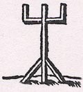
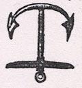
Upon all the Rivers and Streames of Holland, Friesland, and Zeland, the Buyes at the upper ende are rounde and great, and at the lower end, small and sharpe like unto this marke [drawing, conical basketwork, point downwards, moored by rope] being made blacke with Pitche or Tar, lying for the moste parte uppon the right hande in Saylinge out, & on the lefthand in commyng in: And on th'other side for Sandes, flats & shoaldes do commonly stand the Beakons and other higher and more apparent markes made of Oaysers, after this manner [drawing, post with an ovoid wicker, ie osier, basket] that they may be farther of perceaved: And where there is danger of poincts of Rockes, Sandes, & Shoaldes that stande out, there are (that you may shunne them) white Tunnes or Buyes made after this fashion [drawing, a barrel, ie tun, moored by rope] which do alwayes lie upon the contrary side of the foresaid black buyes. The eye markes, whereby you may assuredly finde these buyes and other markes, are sufficie~tly declared in the description before each Charte. But you must understand that the Buyes and markes are herein noted, as they weare Anno. 1582. Moreover because the depthes and channels of the Rivers do yeerly shift and chaunge their places, both by reason of the uncertaintie and instabilitie of the sandie grounds, and for that the entringes and mouthes of the Rivers do dayly ware wider & broder: therfore these streames are to be tried by soundyng, and to be sayled in with skilfull and experienced Pilots and maisters. The lande markes placed at the entries of Rivers I have, for streightnes of roome, marked thus. [drawing, post braced upright, arms out to each side with uprights, like a trident] But where there is a salfe roade & grounde fit for Ankering I have set downe this forme of an Anker. [drawing, anchor, flukes up] The figures that are placed in al Have~s Rivers, Streames & Channels, as well as in the mayne sea as elswhere, upo~ al the shoaldes, Sandes & Rockes, do signifie the depth of the places, as 1. 2. 3. 10. 12. fatham, & so forth: which is alwaies to be understood at half flood or ebbe. The litle Crosses marked in this manner [+] alonge the Coastes neare Islandes and elswhere, betoken hidden and dangerous Rockes, of which you must carefully beware: And where the double crosses are, there lye greater Rockes covered with the water. Thees markes in the Chartes are made thus. [small drawings, symbols for the items described; black spot with line above, circle with line through, circle with line above, trident, anchor]
... the Buyes at the upper ende are rounde and great, and at the lower end, small and sharpe like unto this marke ... being made blacke with Pitche or Tar ...
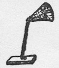
... Beakons and other higher and more apparent markes made of Oaysers, after this manner ... that they may be farther of perceaved ...
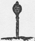
... there are (that you may shunne them) white Tunnes or Buyes made after this fashion ...
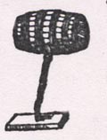
The lande markes placed at the entries of Rivers I have, for streightnes of roome, marked thus ...
... where there is a salfe roade & grounde fit for Ankering I have set downe this forme of an Anker.
These markes in the Chartes are made thus.


A PERFECT DESCRIPTION OF THE SEA COASTES BEWTEENE THE Isle of Wight and Dover.
To goe in at the west end of Wight, you must looke well to the tide for the flood sets very sore upon the Needles, and the ebbe likewise westwarde upon the Shingels and Chalkie Rockes which lie westwardes of the Needles, and it is very narrow between the Needles and the Shingels, wherfore saile directly with the Needles very neere them, and keepe the inner poynt of the Isle right without the Needles: And when you are so come within the Needles, beare somewhat off the Island between the Chesell & The Isles poynte, (Because of the Rockes called the Wardens, which lie on the Wight-side neare the Shore) then turning Eastward over against Calshotte, you must cast anker in 7. or 8. fatham.
But if you will enter at the East ende of Wight, keepe the Castle right against the Lime-kil that lies above Portesmouth until that Culver cliffe come within the point of the Ile, for then shall you have brought the Lyme-kill to the east end of Portesmouth which you must so hold untill the Castle which standeth to the westwards of Portesmouth doo appeare on the East side of the Wood: and then plie sometimes towards Sainct Helens Abbey, keepyng your markes in this sorte, you shall take no hurt on the Shoaldes or Sandes. But if you cannot see the Limekill, then shall you keepe the Castle on the West-side of Culver cliffe, untill you have brought S. Helens church with out the poynte of the Island a shippes length. Then may you freely sayle North-West up, without any danger of the Riffe or tayle-land that lieth out. Then keepe the square Towre between the East ende of Portesmouth and the Castle: untill you may see the Castle which standeth on the West-side of Portesmouth, Eastward of the wood: and so may you goe inwardes.
The marks of those Shoalds and Flats are these, viz. The Castle standinge Eastwards of Portesmouth, and the square towre, wherof I have now treated. When you have brought the Lymekill so much to the Eastward of the Castle, that you may but see betwixt the~, then are you upon a litle shoald, which at low water hath 5. fatham and a halfe: and then have you the Castle that standeth on the west side of Portesmouth, at the West corner of the wood, But when the square towre that standeth by the East of Portesmouth is brought Westward of the Castle: then the Castle by West of Portesmouth standeth at the Woods West ende. You have there at high water 6. fatham. And when the square towre is seen between the East end of Portsmouth and the Castle, and the Castle standeth right betwixt the Limekill and the towre: & likewise when the Castle on the west end of Portesmouth standeth to the Eastwards of the Wood, then have you 11. fatham at high water. But when the Limekill and Portesmouth towre are one, & the castle beareth Westward of the Wood, then have you 10. fatham at high water, and lastly when S. Helens lieth south west and by west from you, then the South east ende of the Shoald beareth North east, and by north from you.
Three leagues Eastward of Weenbridge lieth Arundel, which is a bard haven, & at half flood .2. fatham deepe: you must go in by the West coast, and let fall your anker before the towne in .5. fatham. Foure leagues from Arundell standeth New Shoram, The East side therof hath a gravelly Chesell, where alongest you may sayle in, and in the entries you have .3. fatha~ water at half flood: in the midst before the haven lie rockes under water. The entries on the West side is wide and broad, and is at halfe flood 2. fatham deepe, the haven is large and broade within, where you may anker in 4. or 5. fatham.
If you will sayle into the Cammer of Rye, shape your course alongst the Shingels: and when you shalbe a Cables length of the poynt of the Shingels, turne up towards the Castle of Winchelzey, leaving all the shore or shoald markes upon your starbord, then let fall your Anker in the River of Rie, called the Rother at 4. or 5. fatham: for the Cammer where in times past we were wont to lie is now fowle and full of shoalds.
These countries yeeld litle else but Wooll, Clothe, and Fier-Wood, which are transported from thence.
What does it mean?


Remember that these notes are made for Hampshire, ignoring other parts of the map.
strapwork cartouche
map maker
THE SEA COASTES OF ENGLAND / betweene the Isle of Wight & Dover, with / the principal havens [therrof] according / to their situation and AppearingThe cartouche is decorated with flowers and fruit, and a face.
Engraved lower left is:-
Theodore de Bry. s
compass rose
rhumb lines
up is NW
N NE E SE S SW W NWand north is marked with a fleur de lys.
The map is not quite 'upright'; up on the sheet is about NWbyN.
scale
English leagues 20 in a degreewith 7 numbered divisions. 7 leagues = 95.6mm. A league is 3 sea miles; a degree is 69.17 statute miles. Thus the map scale is roughly about:-
1 to 410000
6 1/2 statute miles to 1 inchalso:-
Spanish leagues [17 1/2] in a degreewith 6 numbered divisions. 6 leagues = 92.0mm.
Dutch leagues [15] in a degreewith 5 numbered divisions. 5 leagues = 90.1mm.
These are presented in a strapwork cartouche lower left.
sea plain
sandbanks
anchorages
depth soundings
THE CHANELL BETWEENE ENGLAND AND FRAUNCEThere are depth soundings in the sea area, in fathoms, ranging from 2 close to shore to 35 out in the channel.
Sandbanks are indicated between the Isle of Wight and the mainland.
Anchorages are shown by a ships anchor in the sea between the Isle of Wight and Southampton Water, and at Spithead, etc.
coast appearance
harbours
The Ile of Wight as it appeareth when you sayle there alongst two leagues ofThe coast line is not as accurate as it could be. The position of features is all awry.
Southampton Water and Hamble Haven are drawn; Portsmouth Harbour is drawn; Langston and Chichester harbours are missing.
Interpretation is chancy; while the gross information of the chart is fine, I would not have liked to have relied upon it for harbouring!
ANGLIAE PARS
parks
Sandwich baye
Studland bay
Poole
Shingels
Lemingto~
Hurst ca:
Falley
Calshot
Eling
S Hampton
Upham
Tichfeld
Porchester
Southwik
Portesmouth
Southsea cast
StanstedThe land is decorated, vastly out of scale, with perspective drawings of parks, great houses, etc. There is a large ?sheep in Dorset, and some ?cattle in Sussex.
Places on the Isle of Wight are:-
The needles
Cow cast
Casbrok
Newport
Ryde
Elene sand
Steven
S. Ellens point
Culver Clif
Wolvarton
Donnoze


| dutch chart | english chart | today | ||
| Studland bay | Studland Bay (Dorset) | |||
| Polle. | Poole | Poole | (Dorset) | |
| Hors. Cingels. | Shingels | Hurst Spit | perhaps | |
| Cingels | Singel | Shingles | a series of sandbanks lying SW of Hurst Spit | |
| Hurst ca. | Hurst Castle | drawing of castle | ||
| Fallan. | Falley | Fawley | label swapped with Lymington on the dutch edition | |
| Calshot | Calshot Castle | drawing of castle | ||
| Lemton. | Lemingto~ | Lymington | label swapped with Fawley on the dutch edition | |
| Dypdon. | Dibden | |||
| Eling | Eling | |||
| Hampton. | S Hampton | Southampton | ||
| drawing of a castle? west bank of the Itchen | ||||
| Upham. | Upham | Upham | ||
| Tichfeldt. | Tichfeld | Titchfield | ||
| drawing of a castle? | ||||
| St Andrews Castle | drawing of a castle | |||
| Porchester Castle | drawing of a castle | |||
| Portchester | Porchester | Fareham | ||
| Southwik. | Southwik | Southwick | ||
| Porshmout. | Portesmouth | Portsmouth | ||
| Southsea cast | Southsea Castle | drawing of a castle |


Spieghel der Zeevaerdt
Spiegels der Seefart
Speculum Nauticum
Mariners Mirrour


Waghenaer, Lucas J: 1588 (English edn): Mariners Mirrour: Ashley, Anthony (London)
Koeman, C: 1965: Luca Janszoon Waghenaer, a Sixteenth Century Marine Cartographer: Geographical Journal: vol.131: pp.202-212
Waghenaer, Lucas J: 1966 (facsimile) & 1588 (English edn): Mariners Mirrour: Theatrum Orbis Terrarum (Amsterdam, Netherlands)


